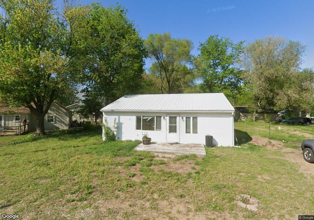
202 Locust St Forest City, IL 61532
Estimated Value: $48,000 - $108,000
3
Beds
1
Bath
1,080
Sq Ft
$67/Sq Ft
Est. Value
About This Home
This home is located at 202 Locust St, Forest City, IL 61532 and is currently estimated at $72,623, approximately $67 per square foot. 202 Locust St is a home with nearby schools including Midwest Central Primary School, Midwest Central Middle School, and Midwest Central High School.
Ownership History
Date
Name
Owned For
Owner Type
Purchase Details
Closed on
Apr 4, 2017
Sold by
Regions Bank
Bought by
Wooding Devin and Wooding Kati
Current Estimated Value
Purchase Details
Closed on
Mar 22, 2017
Sold by
Ms Investment Group Inc
Bought by
Regions Bank
Purchase Details
Closed on
Mar 6, 2017
Sold by
Mason County
Bought by
Ms Investment Group Inc
Purchase Details
Closed on
Mar 28, 2008
Sold by
Homesales Inc
Bought by
Hummel Patricia A
Purchase Details
Closed on
Jun 12, 2007
Sold by
Boatz Christy
Bought by
Homesales Inc
Create a Home Valuation Report for This Property
The Home Valuation Report is an in-depth analysis detailing your home's value as well as a comparison with similar homes in the area
Purchase History
| Date | Buyer | Sale Price | Title Company |
|---|---|---|---|
| Wooding Devin | $7,000 | None Available | |
| Regions Bank | $8,000 | None Available | |
| Ms Investment Group Inc | -- | None Available | |
| Hummel Patricia A | $10,000 | None Available | |
| Homesales Inc | -- | None Available |
Source: Public Records
Tax History
| Year | Tax Paid | Tax Assessment Tax Assessment Total Assessment is a certain percentage of the fair market value that is determined by local assessors to be the total taxable value of land and additions on the property. | Land | Improvement |
|---|---|---|---|---|
| 2024 | $629 | $6,862 | $3,031 | $3,831 |
| 2023 | $629 | $6,339 | $2,800 | $3,539 |
| 2022 | $572 | $5,764 | $2,546 | $3,218 |
| 2021 | $539 | $5,342 | $2,360 | $2,982 |
| 2020 | $541 | $5,342 | $2,360 | $2,982 |
| 2019 | $538 | $5,342 | $2,360 | $2,982 |
| 2018 | $546 | $5,342 | $2,360 | $2,982 |
| 2017 | $548 | $5,342 | $2,360 | $2,982 |
| 2016 | $1,547 | $14,555 | $2,360 | $12,195 |
| 2015 | $1,468 | $14,555 | $2,360 | $12,195 |
| 2012 | $1,468 | $14,228 | $2,307 | $11,921 |
Source: Public Records
Map
Nearby Homes
- 204 Chestnut
- 100 S Main St
- 29126 CR 2100 N
- 30772 E County Road 2400 N
- 29847 E County Road 2600 N County Rd
- 101 S Harrison St
- 100 N Adams St
- 0 N Broadway St
- 22648 Fleming Rd
- 7865 Spring Lake Rd
- 3833 Norwood Rd
- 12450 Sunset Dr
- 210 N 2nd St
- 113 N 1st St
- 406 E Mason St
- 107 S Hayes St
- 15085 Woodrow Rd
- 17021 N County Road 1840 E
- 153 E Main St
- 10844 CR 2950 Rd E
Your Personal Tour Guide
Ask me questions while you tour the home.