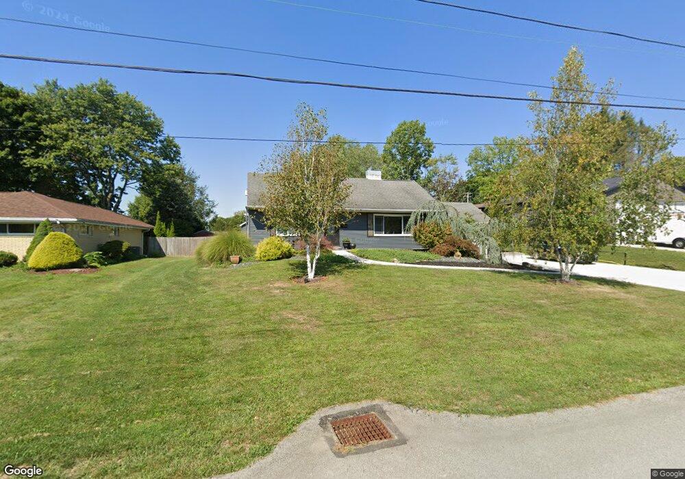
202 Maple Dr Trafford, PA 15085
Estimated Value: $100,561 - $314,000
4
Beds
2
Baths
2,100
Sq Ft
$115/Sq Ft
Est. Value
About This Home
This home is located at 202 Maple Dr, Trafford, PA 15085 and is currently estimated at $242,390, approximately $115 per square foot. 202 Maple Dr is a home located in Westmoreland County with nearby schools including Penn Trafford High School and Mother of Sorrows School.
Ownership History
Date
Name
Owned For
Owner Type
Purchase Details
Closed on
Apr 28, 2009
Sold by
Kirkpatrick Christine M and Hilbert Kathy
Bought by
Hlad Adam J and Hlad Christine M
Current Estimated Value
Home Financials for this Owner
Home Financials are based on the most recent Mortgage that was taken out on this home.
Original Mortgage
$64,800
Outstanding Balance
$40,986
Interest Rate
4.87%
Mortgage Type
Purchase Money Mortgage
Estimated Equity
$201,404
Create a Home Valuation Report for This Property
The Home Valuation Report is an in-depth analysis detailing your home's value as well as a comparison with similar homes in the area
Home Values in the Area
Average Home Value in this Area
Purchase History
| Date | Buyer | Sale Price | Title Company |
|---|---|---|---|
| Hlad Adam J | $81,000 | None Available |
Source: Public Records
Mortgage History
| Date | Status | Borrower | Loan Amount |
|---|---|---|---|
| Open | Hlad Adam J | $64,800 |
Source: Public Records
Tax History
| Year | Tax Paid | Tax Assessment Tax Assessment Total Assessment is a certain percentage of the fair market value that is determined by local assessors to be the total taxable value of land and additions on the property. | Land | Improvement |
|---|---|---|---|---|
| 2025 | $3,163 | $23,100 | $2,690 | $20,410 |
| 2024 | $3,140 | $23,100 | $2,690 | $20,410 |
| 2023 | $2,979 | $23,100 | $2,690 | $20,410 |
| 2022 | $2,944 | $23,100 | $2,690 | $20,410 |
| 2021 | $2,921 | $23,100 | $2,690 | $20,410 |
| 2020 | $2,898 | $23,100 | $2,690 | $20,410 |
| 2019 | $2,828 | $16,360 | $2,690 | $13,670 |
| 2018 | $1,946 | $16,360 | $2,690 | $13,670 |
| 2017 | $1,897 | $16,360 | $2,690 | $13,670 |
| 2016 | $1,841 | $16,360 | $2,690 | $13,670 |
| 2015 | $1,841 | $16,360 | $2,690 | $13,670 |
| 2014 | $1,808 | $16,360 | $2,690 | $13,670 |
Source: Public Records
Map
Nearby Homes
- 106 Autumn Dr
- 708 State Route 130
- 301 Pine Hollow Rd
- 233 Saunders Station Rd
- 117 Plum Dr
- 104&106 7th Street Extension
- 104 & 106 7th Street Extension
- 3469 Mayer Dr
- 5010 Prides Ct
- 1004 Christina Ct
- Lot#2 Meadowbrook Rd
- 3541 Mcwilliams Rd
- 123 Bee Ln
- 1360 Abers Creek Rd
- 1021 Greggerson Rd
- 317 Alpine Village Dr
- - Old Ramsey Rd
- 2117 Berkshire Dr
- 2174 Ramsey Rd
- 210 Gotham Ln
- 200 Maple Dr
- 501 Cypress Ct
- 503 Cypress Ct
- 201 Maple Dr
- 504 Shady Dr
- 203 Maple Dr
- 502 Shady Dr
- 207 Murrysville Rd
- 211 Murrysville Rd
- 4003 Sr Rd
- 600 Shady Dr
- 2 L Green Place
- 500 Cypress Ct
- 205 Murrysville Rd
- 203 Murrysville Rd
- 4033 Sr Rd
- 303 Murrysville Rd
- 500 Shady Dr
- 305 Murrysville Rd
- 602 Shady Dr
Your Personal Tour Guide
Ask me questions while you tour the home.