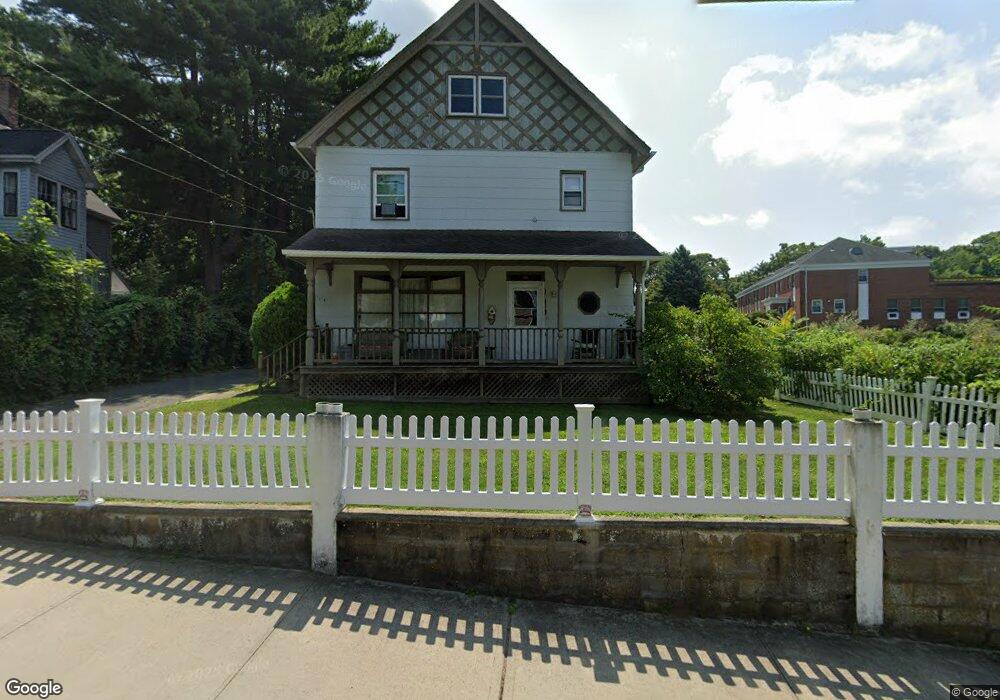
202 Myrtle Ave Port Jefferson, NY 11777
Estimated Value: $705,230 - $847,000
--
Bed
--
Bath
--
Sq Ft
0.3
Acres
About This Home
This home is located at 202 Myrtle Ave, Port Jefferson, NY 11777 and is currently estimated at $776,115. 202 Myrtle Ave is a home located in Suffolk County with nearby schools including Edna Louise Spear Elementary, Port Jefferson Middle School, and Earl L Vandermeulen High School.
Ownership History
Date
Name
Owned For
Owner Type
Purchase Details
Closed on
Mar 19, 2004
Sold by
Baker Russell S and Baker Linda A
Bought by
Baker Eric W
Current Estimated Value
Purchase Details
Closed on
Nov 20, 2002
Sold by
Baker Linda A and Baker Russell S
Bought by
Baker Eric W
Purchase Details
Closed on
Dec 4, 2001
Sold by
Baker Russell S and Baker Linda A
Bought by
Baker Russell S and Baker Linda A
Purchase Details
Closed on
Aug 4, 2000
Sold by
Schwartz Michael and Didonato Donna
Bought by
Baker Russell S and Baker Linda A
Home Financials for this Owner
Home Financials are based on the most recent Mortgage that was taken out on this home.
Original Mortgage
$240,000
Interest Rate
8.13%
Mortgage Type
Purchase Money Mortgage
Create a Home Valuation Report for This Property
The Home Valuation Report is an in-depth analysis detailing your home's value as well as a comparison with similar homes in the area
Home Values in the Area
Average Home Value in this Area
Purchase History
| Date | Buyer | Sale Price | Title Company |
|---|---|---|---|
| Baker Eric W | -- | Safe Harbor Title Agency Ltd | |
| Baker Eric W | $300,000 | Safe Harbor Title Agency Ltd | |
| Baker Russell S | -- | -- | |
| Baker Russell S | $320,000 | Safe Harbor Title Agency |
Source: Public Records
Mortgage History
| Date | Status | Borrower | Loan Amount |
|---|---|---|---|
| Closed | Baker Russell S | $240,000 |
Source: Public Records
Tax History Compared to Growth
Tax History
| Year | Tax Paid | Tax Assessment Tax Assessment Total Assessment is a certain percentage of the fair market value that is determined by local assessors to be the total taxable value of land and additions on the property. | Land | Improvement |
|---|---|---|---|---|
| 2024 | $16,021 | $5,250 | $550 | $4,700 |
| 2023 | $16,021 | $5,250 | $550 | $4,700 |
| 2022 | $12,040 | $5,250 | $550 | $4,700 |
| 2021 | $12,040 | $5,250 | $550 | $4,700 |
| 2020 | $14,471 | $5,250 | $550 | $4,700 |
| 2019 | $14,417 | $0 | $0 | $0 |
| 2018 | $11,730 | $5,250 | $550 | $4,700 |
| 2017 | $11,730 | $5,250 | $550 | $4,700 |
| 2016 | $11,717 | $5,250 | $550 | $4,700 |
| 2015 | -- | $5,250 | $550 | $4,700 |
| 2014 | -- | $5,250 | $550 | $4,700 |
Source: Public Records
Map
Nearby Homes
- 515 High St Unit 17
- 213 Maiden Ln
- 22 Vantage Ct
- 109 Spring St
- 5 Princess Tree Ct
- 0 Belle Terre Rd
- 127 Barnum Ave
- 105 Willis Ave
- 111 Campbell St
- 95 Sheep Pasture Rd
- 110 E Broadway
- 319 Thompson St
- 109 Scraggy Hill Rd
- 125 Bleeker St
- 0 Dark Hollow Rd
- 1 Oakwood Rd
- 101 Wilson Dr
- 26 Wilson St
- 10 Sea Court Ln
- 2 Puritan Path