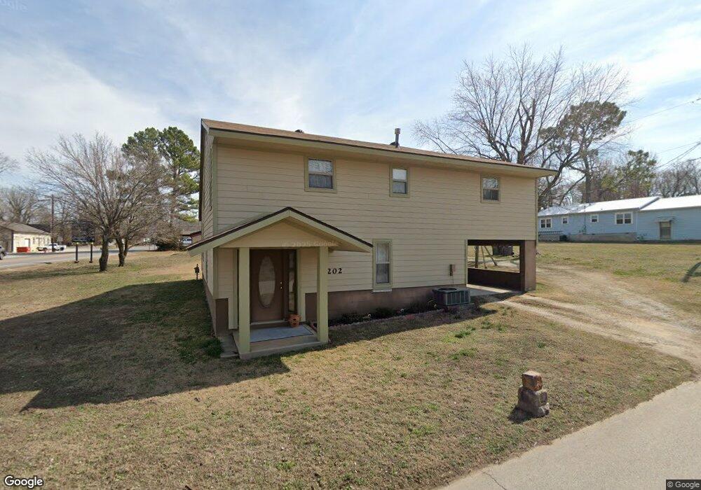
202 N Allen St Cave Springs, AR 72718
Estimated Value: $346,000 - $425,000
3
Beds
3
Baths
2,140
Sq Ft
$181/Sq Ft
Est. Value
About This Home
This home is located at 202 N Allen St, Cave Springs, AR 72718 and is currently estimated at $387,769, approximately $181 per square foot. 202 N Allen St is a home located in Benton County with nearby schools including Evening Star Elementary School, Bright Field Middle School, and Fulbright Junior High School.
Ownership History
Date
Name
Owned For
Owner Type
Purchase Details
Closed on
Apr 29, 2025
Sold by
Wright Darrell M and Wright Darrell Max
Bought by
Arkansas State Highway Commission
Current Estimated Value
Purchase Details
Closed on
Mar 3, 2003
Bought by
Hartman
Purchase Details
Closed on
Oct 31, 1977
Bought by
Wright D
Purchase Details
Closed on
Jun 26, 1975
Bought by
Wright D
Purchase Details
Closed on
Oct 16, 1973
Bought by
Wright
Purchase Details
Closed on
Aug 17, 1973
Bought by
Mathews
Create a Home Valuation Report for This Property
The Home Valuation Report is an in-depth analysis detailing your home's value as well as a comparison with similar homes in the area
Home Values in the Area
Average Home Value in this Area
Purchase History
| Date | Buyer | Sale Price | Title Company |
|---|---|---|---|
| Arkansas State Highway Commission | $393,894 | None Listed On Document | |
| Hartman | $30,000 | -- | |
| Wright D | -- | -- | |
| Wright H | -- | -- | |
| Wright D | $7,000 | -- | |
| Wright | -- | -- | |
| Mathews | -- | -- |
Source: Public Records
Tax History Compared to Growth
Tax History
| Year | Tax Paid | Tax Assessment Tax Assessment Total Assessment is a certain percentage of the fair market value that is determined by local assessors to be the total taxable value of land and additions on the property. | Land | Improvement |
|---|---|---|---|---|
| 2025 | -- | -- | -- | -- |
| 2024 | $1,064 | $47,031 | $17,000 | $30,031 |
| 2023 | $1,064 | $30,450 | $4,000 | $26,450 |
| 2022 | $674 | $30,450 | $4,000 | $26,450 |
| 2021 | $1,038 | $30,450 | $4,000 | $26,450 |
| 2020 | $985 | $22,320 | $3,400 | $18,920 |
| 2019 | $932 | $22,320 | $3,400 | $18,920 |
| 2018 | $903 | $22,320 | $3,400 | $18,920 |
| 2017 | $797 | $22,320 | $3,400 | $18,920 |
| 2016 | $797 | $22,320 | $3,400 | $18,920 |
| 2015 | $1,025 | $17,890 | $950 | $16,940 |
| 2014 | $675 | $17,890 | $950 | $16,940 |
Source: Public Records
Map
Nearby Homes
- 9723 Thunderhead Ln
- 206 S Gleneagle Dr
- 713 Gleneagle Cir
- 9739 Soaring Hawk Dr
- 323 & 335 S Main St
- 203 N Cascade Cir
- Tract 5, Lot 2 Farrar Rd
- 11962 Farrar Rd
- Tract 5, Lot 1 Farrar Rd
- 348 Whitcliff Dr
- 481 Whitcliff Dr
- 868 N Main St
- 0 Hwy 112 and N Wallis Rd Unit Lot B 1269862
- 0 Hwy 112 and N Wallis Rd Unit Lot E 1269870
- 0 Hwy 112 and N Wallis Rd Unit Lot D 1269867
- 0 Hwy 112 and N Wallis Rd Unit Lot A 1269859
- 0 Hwy 112 and N Wallis Rd Unit Lot C 1269864
- 609 Sands Rd
- 1418 Lookout Ln
- 1420 Lookout Ln
- . Corner of Allen & 264
- 0 Allen St
- 213 N Allen St
- 170 Stroud Ave
- 200 Sand Bar Ln Unit D
- 181 Chestnut St
- 161 N Allen St
- 137 Healing Springs Rd
- 113 N Allen St
- 202 Sand Bar Ln Unit A
- 169 Stroud Ave
- 139 Chestnut St
- 223 N Main St
- 142 Healing Springs Rd
- 11.51 W Highway 264
- 137 N Main St
- 150 W Midway Ave
- 148 Ac Main St
- 180 N Main St
- 180 & 221 Main St