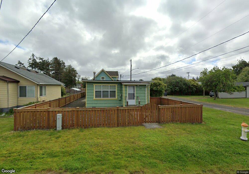
202 N Hoquiam St Westport, WA 98595
Estimated Value: $201,000 - $271,000
--
Bed
--
Bath
576
Sq Ft
$420/Sq Ft
Est. Value
About This Home
This home is located at 202 N Hoquiam St, Westport, WA 98595 and is currently estimated at $241,768, approximately $419 per square foot. 202 N Hoquiam St is a home with nearby schools including Ocosta Elementary School and Ocosta Junior/Senior High School.
Ownership History
Date
Name
Owned For
Owner Type
Purchase Details
Closed on
Feb 19, 2015
Sold by
Fosbre Edward and Bard Tammie
Bought by
Helen Barbara
Current Estimated Value
Purchase Details
Closed on
Jan 5, 2006
Sold by
Halbert Michael O and Halbert Sharon Lea
Bought by
Fosbre Edward and Bard Tammie
Home Financials for this Owner
Home Financials are based on the most recent Mortgage that was taken out on this home.
Original Mortgage
$71,600
Interest Rate
6.25%
Mortgage Type
New Conventional
Create a Home Valuation Report for This Property
The Home Valuation Report is an in-depth analysis detailing your home's value as well as a comparison with similar homes in the area
Home Values in the Area
Average Home Value in this Area
Purchase History
| Date | Buyer | Sale Price | Title Company |
|---|---|---|---|
| Helen Barbara | $70,000 | Coast Title | |
| Fosbre Edward | $89,500 | Coast Title |
Source: Public Records
Mortgage History
| Date | Status | Borrower | Loan Amount |
|---|---|---|---|
| Previous Owner | Fosbre Edward | $71,600 |
Source: Public Records
Tax History Compared to Growth
Tax History
| Year | Tax Paid | Tax Assessment Tax Assessment Total Assessment is a certain percentage of the fair market value that is determined by local assessors to be the total taxable value of land and additions on the property. | Land | Improvement |
|---|---|---|---|---|
| 2025 | $1,832 | $215,261 | $56,867 | $158,394 |
| 2023 | $1,836 | $205,267 | $56,867 | $148,400 |
| 2022 | $2,272 | $197,298 | $19,950 | $177,348 |
| 2021 | $2,140 | $197,298 | $19,950 | $177,348 |
| 2020 | $1,721 | $169,927 | $19,000 | $150,927 |
| 2019 | $1,549 | $130,887 | $21,000 | $109,887 |
| 2018 | $1,325 | $120,897 | $21,000 | $99,897 |
| 2017 | $560 | $92,355 | $21,000 | $71,355 |
| 2016 | $649 | $47,545 | $21,000 | $26,545 |
| 2014 | -- | $52,045 | $21,000 | $31,045 |
| 2013 | -- | $82,135 | $25,000 | $57,135 |
Source: Public Records
Map
Nearby Homes
- 0 N Forrest St Unit NWM2417282
- 201 S Hoquiam St
- 0 Olympia St Unit NWM2367648
- 331 N Melbourne St
- 280 S Surf St
- 401 S Starr St
- 711 N Baker St
- 603 W Veterans Ave
- 507 W Veterans Ave
- 0 Surf St Unit NWM2408053
- 608 S Forrest St
- 500 Starr St
- 0 XX Starr St
- 730 N Adams St
- 605 N Montesano St
- 710 S Hancock Ave Unit 419+
- 710 S Hancock Ave Unit 328
- 710 S Hancock Ave Unit 102&3
- 710 S Hancock Ave Unit 111
- 710 S Hancock Ave Unit 301
- 208 N Hoquiam
- 717 Seattle Ave W
- 201 N Hoquiam St
- 802 W Ocean Ave
- 711 Seattle Ave W
- 201 N Forrest St
- 207 N Hoquiam St
- 207 N Forrest St
- 115 N Hoquiam St
- 211 N Forrest St
- 215 N Forrest St
- 231 N Forrest St
- 720 W Ocean Ave
- 712 W Ocean Ave
- 221 N Hoquiam St
- 700 W Ocean Ave
- 810 W Ocean Ave
- 299 N Forrest St
- 270 N Aberdeen St
- 311 N Hoquiam St