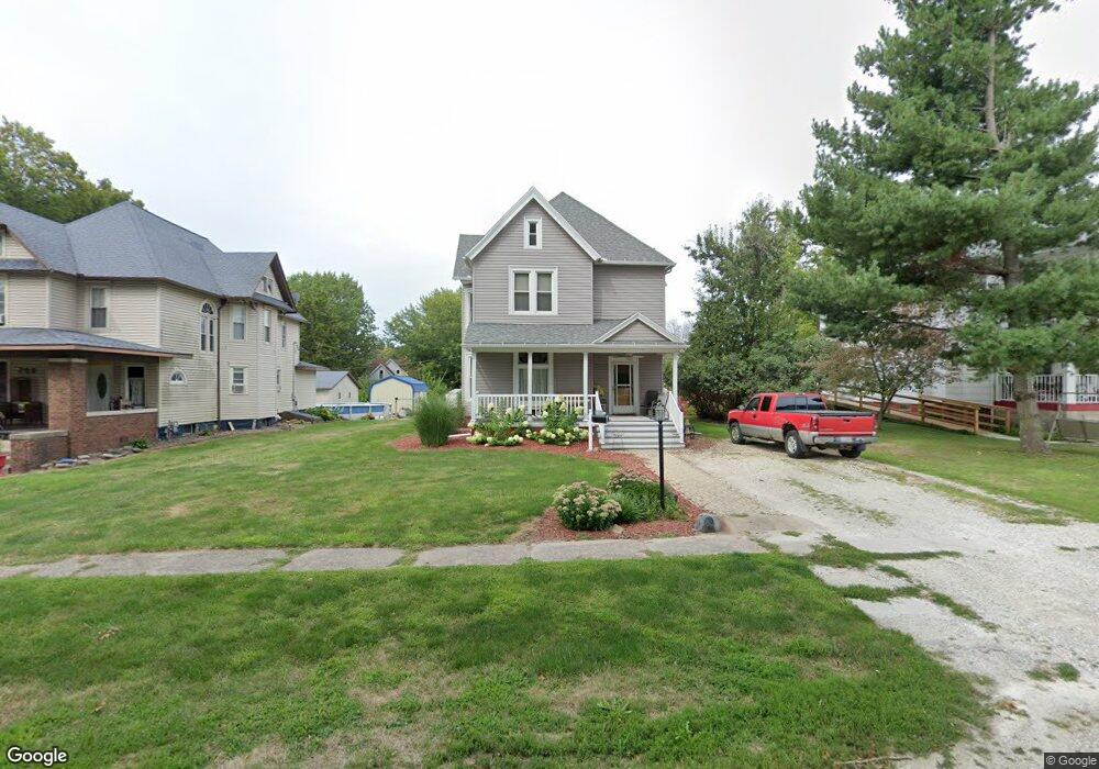
202 N Swarts Ave Abingdon, IL 61410
Estimated Value: $102,010 - $137,000
3
Beds
2
Baths
1,880
Sq Ft
$61/Sq Ft
Est. Value
About This Home
This home is located at 202 N Swarts Ave, Abingdon, IL 61410 and is currently estimated at $113,753, approximately $60 per square foot. 202 N Swarts Ave is a home located in Knox County with nearby schools including Hedding Grade School, Avon Elementary School, and Abingdon-Avon Middle School.
Ownership History
Date
Name
Owned For
Owner Type
Purchase Details
Closed on
Apr 9, 2021
Sold by
Thurman Roger R and Thurman Mindy K
Bought by
Sargeant Jade A
Current Estimated Value
Home Financials for this Owner
Home Financials are based on the most recent Mortgage that was taken out on this home.
Original Mortgage
$77,569
Outstanding Balance
$69,922
Interest Rate
2.9%
Mortgage Type
Construction
Estimated Equity
$43,831
Create a Home Valuation Report for This Property
The Home Valuation Report is an in-depth analysis detailing your home's value as well as a comparison with similar homes in the area
Home Values in the Area
Average Home Value in this Area
Purchase History
| Date | Buyer | Sale Price | Title Company |
|---|---|---|---|
| Sargeant Jade A | $79,000 | Attorney Only |
Source: Public Records
Mortgage History
| Date | Status | Borrower | Loan Amount |
|---|---|---|---|
| Open | Sargeant Jade A | $77,569 | |
| Closed | Sargeant Jade A | $77,569 |
Source: Public Records
Tax History Compared to Growth
Tax History
| Year | Tax Paid | Tax Assessment Tax Assessment Total Assessment is a certain percentage of the fair market value that is determined by local assessors to be the total taxable value of land and additions on the property. | Land | Improvement |
|---|---|---|---|---|
| 2024 | $2,049 | $31,140 | $2,640 | $28,500 |
| 2023 | $2,049 | $28,100 | $2,380 | $25,720 |
| 2022 | $1,820 | $26,700 | $2,260 | $24,440 |
| 2021 | $1,606 | $23,890 | $2,170 | $21,720 |
| 2020 | $2,072 | $22,970 | $2,090 | $20,880 |
| 2019 | $1,568 | $22,740 | $2,070 | $20,670 |
| 2018 | $1,509 | $22,080 | $2,010 | $20,070 |
| 2017 | $1,484 | $21,650 | $1,970 | $19,680 |
| 2015 | -- | $21,220 | $1,930 | $19,290 |
| 2013 | $1,422 | $21,010 | $1,910 | $19,100 |
Source: Public Records
Map
Nearby Homes
- 103 N Swarts St
- 407 W Martin St
- 108 W Jackson St
- 500 N Monroe St
- 204 S Washington St
- 106 E Jackson St
- 214 S Main St
- 206 W Lower St
- 211 S Froelich Ln
- 306 N Harshbarger St
- 204 E Adams St
- 704 N Cherry St
- 405 W Memorial Dr
- 205 N Austin Ave
- 103 W Givens St
- 403 1/2 E Jared St
- 369 Knox Highway 23
- 1196 160th St
- 1077 Knox Road 500 E
- 572 Knox Highway 26
- 202 N Swarts St
- 200 N Swarts Ave
- 204 N Swarts Ave
- 206 N Swarts Ave
- 206 N Swarts St
- 203 N Pennsylvania St
- 205 N Pennsylvania St
- 201 N Pennsylvania St
- 207 N Pennsylvania St
- 203 N Swarts Ave
- 205 N Swarts Ave
- 106 N Swarts Ave
- 207 N Swarts Ave
- 305 W Jackson St
- 406 W Jackson St
- 300 N Swarts Ave
- 308 W Jackson St
- 409 W Pearl St
- 309 W Pearl St
- 302 N Swarts Ave