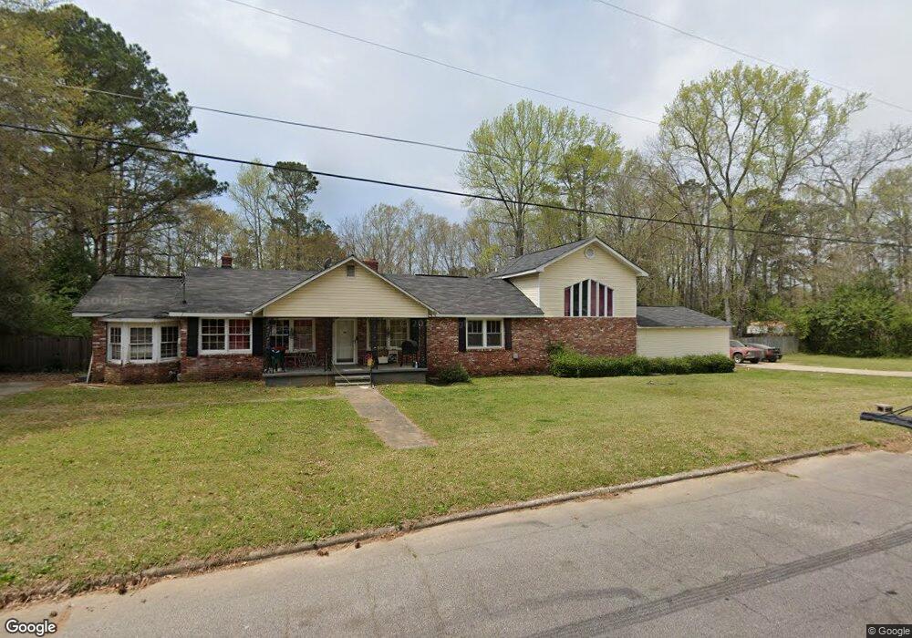
202 Nevada St Lagrange, GA 30241
Estimated Value: $196,000 - $261,000
4
Beds
2
Baths
2,420
Sq Ft
$96/Sq Ft
Est. Value
About This Home
This home is located at 202 Nevada St, Lagrange, GA 30241 and is currently estimated at $233,294, approximately $96 per square foot. 202 Nevada St is a home located in Troup County with nearby schools including Whitesville Road Elementary School, Berta Weathersbee Elementary School, and Rosemont Elementary School.
Ownership History
Date
Name
Owned For
Owner Type
Purchase Details
Closed on
Nov 1, 1982
Sold by
Brenda Jimmie R and Brenda Clegg
Bought by
Edmondson Glenda Faye
Current Estimated Value
Purchase Details
Closed on
Nov 11, 1981
Sold by
George H Clegg
Bought by
Brenda Jimmie R and Brenda Clegg
Purchase Details
Closed on
Jan 1, 1974
Sold by
Donald L Daniel
Bought by
George H Clegg
Purchase Details
Closed on
Jan 1, 1973
Sold by
George H Clegg
Bought by
Donald L Daniel
Purchase Details
Closed on
Jan 1, 1947
Bought by
George H Clegg
Create a Home Valuation Report for This Property
The Home Valuation Report is an in-depth analysis detailing your home's value as well as a comparison with similar homes in the area
Home Values in the Area
Average Home Value in this Area
Purchase History
| Date | Buyer | Sale Price | Title Company |
|---|---|---|---|
| Edmondson Glenda Faye | $4,000 | -- | |
| Brenda Jimmie R | -- | -- | |
| George H Clegg | -- | -- | |
| Donald L Daniel | -- | -- | |
| George H Clegg | -- | -- |
Source: Public Records
Tax History Compared to Growth
Tax History
| Year | Tax Paid | Tax Assessment Tax Assessment Total Assessment is a certain percentage of the fair market value that is determined by local assessors to be the total taxable value of land and additions on the property. | Land | Improvement |
|---|---|---|---|---|
| 2024 | $1,984 | $72,760 | $5,560 | $67,200 |
| 2023 | $1,845 | $67,640 | $5,560 | $62,080 |
| 2022 | $1,579 | $56,560 | $5,560 | $51,000 |
| 2021 | $1,582 | $52,440 | $5,560 | $46,880 |
| 2020 | $1,582 | $52,440 | $5,560 | $46,880 |
| 2019 | $1,450 | $48,080 | $5,560 | $42,520 |
| 2018 | $1,450 | $48,072 | $5,552 | $42,520 |
| 2017 | $1,450 | $48,072 | $5,552 | $42,520 |
| 2016 | $1,404 | $46,560 | $5,552 | $41,008 |
| 2015 | $1,407 | $46,560 | $5,552 | $41,008 |
| 2014 | $1,344 | $44,402 | $5,552 | $38,850 |
| 2013 | -- | $46,729 | $5,552 | $41,177 |
Source: Public Records
Map
Nearby Homes
- 913 Arizona St Unit A AND B
- 319 Cooley Rd
- 137 Edgewood Ave
- LOT 15 Edgewood Ave
- 0 Kelley St Unit 10550311
- 957 Kelley St
- 1017 Mason St
- 75 Thomas Rd
- 1604 S Davis Rd
- LOT 4 Borton St
- LOT 3 Borton St
- LOT 5 Borton St
- LOT 6 Borton St
- 213 Euclid Ave
- 216 Euclid Ave
- 626 Smoot St
- 510 Smoot St
- 206 Clearview Ct
- 0 Lanett Ave
- 0 Upper Big Springs Rd Unit 10545622
- 210 Nevada St
- 0 Nevada St Unit 8169671
- 0 Nevada St Unit 8111491
- 0 Nevada St Unit 3149867
- 102 Nevada St
- 203 Nevada St
- 211 Nevada St
- 201 Nevada St
- 214 Nevada St
- 100 Nevada St
- 913A Arizona St Unit B
- 101 Nevada St
- 918 Arizona St
- 906 Utah St
- 834 Colquitt St
- 836 Colquitt St
- 218 Nevada St
- 828 Colquitt St
- 917 Arizona St Unit B
- 915 Utah St