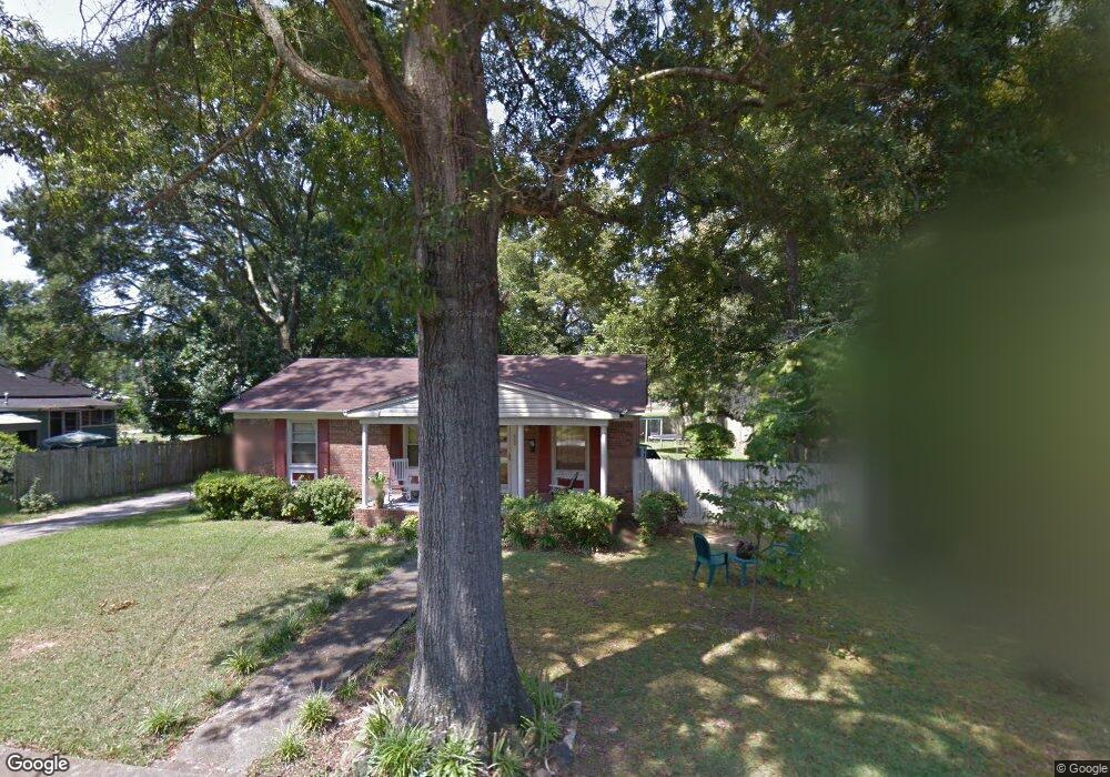
202 Newsome St Union Point, GA 30669
Estimated Value: $174,565 - $208,000
3
Beds
2
Baths
1,318
Sq Ft
$142/Sq Ft
Est. Value
About This Home
This home is located at 202 Newsome St, Union Point, GA 30669 and is currently estimated at $187,391, approximately $142 per square foot. 202 Newsome St is a home located in Greene County with nearby schools including Greene County High School.
Ownership History
Date
Name
Owned For
Owner Type
Purchase Details
Closed on
Oct 17, 1994
Sold by
Farmers Bank
Bought by
Price Samuel L and Price Regina
Current Estimated Value
Purchase Details
Closed on
May 28, 1993
Sold by
Smith Charles M and Smith Sandra
Bought by
Farmers Bank
Purchase Details
Closed on
Jan 1, 1984
Sold by
Smith Larry D and Smith Nancy
Bought by
Smith Charles M and Smith Sandra
Purchase Details
Closed on
Jan 1, 1982
Sold by
Powell Gloria
Bought by
Smith Larry D and Smith Nancy
Purchase Details
Closed on
Jan 1, 1979
Sold by
Sims Robert T and Sims Agnes
Bought by
Powell Gloria
Purchase Details
Closed on
Jan 1, 1971
Sold by
Union Mfg Co
Bought by
Sims Robert T and Sims Agnes
Purchase Details
Closed on
Jan 1, 1967
Bought by
Union Mfg Co
Create a Home Valuation Report for This Property
The Home Valuation Report is an in-depth analysis detailing your home's value as well as a comparison with similar homes in the area
Home Values in the Area
Average Home Value in this Area
Purchase History
| Date | Buyer | Sale Price | Title Company |
|---|---|---|---|
| Price Samuel L | $35,000 | -- | |
| Farmers Bank | $47,600 | -- | |
| Smith Charles M | -- | -- | |
| Smith Larry D | -- | -- | |
| Powell Gloria | -- | -- | |
| Sims Robert T | -- | -- | |
| Union Mfg Co | -- | -- |
Source: Public Records
Tax History Compared to Growth
Tax History
| Year | Tax Paid | Tax Assessment Tax Assessment Total Assessment is a certain percentage of the fair market value that is determined by local assessors to be the total taxable value of land and additions on the property. | Land | Improvement |
|---|---|---|---|---|
| 2024 | $828 | $47,680 | $2,440 | $45,240 |
| 2023 | $795 | $45,880 | $2,440 | $43,440 |
| 2022 | $473 | $41,480 | $2,440 | $39,040 |
| 2021 | $485 | $36,840 | $2,440 | $34,400 |
| 2020 | $450 | $16,160 | $2,680 | $13,480 |
| 2019 | $462 | $16,160 | $2,680 | $13,480 |
| 2018 | $324 | $16,160 | $2,680 | $13,480 |
| 2017 | $415 | $16,188 | $2,700 | $13,488 |
| 2016 | $434 | $16,868 | $2,700 | $14,168 |
| 2015 | $403 | $16,868 | $2,700 | $14,168 |
| 2014 | $407 | $16,697 | $2,700 | $13,997 |
Source: Public Records
Map
Nearby Homes
- 202 Veazey St
- 504 Crawfordville Rd
- 606 Bryan Ave
- 0 Woodland Ct Unit 1027434
- 0 Woodland Ct Unit 10543600
- 324 N Rhodes St
- 215 Hunter St
- 1041 Hillcrest Dr
- 1180 Moody St
- 0 S Rhodes St Unit 10618488
- 1241 Old Siloam Rd
- 1010 Orear Rd
- 0 Washington Hwy Unit 7276060
- 1860 Washington Hwy
- 0 Buffalo Lick Rd Unit 10551328
- 1201 Buffalo Lick Rd
- 0 Buffalo Lick Rd Unit 10551325
- 0 Buffalo Lick Rd Unit 10551234
- 1251 Adams Rd
- 0 Old Union Point Rd Unit 1 10557753
- 200 Newsome St
- 204 Newsome St
- 203 Witcher St
- 205 Witcher St
- 201 Witcher St
- 305 Hart Ave
- 0 Newsome St Unit 8274681
- 0 Newsome St
- 206 Newsome St
- 207 Witcher St
- 112 Newsome St
- 203 Newsome St
- 404 Hart Ave
- 306 Hart Ave
- 209 Witcher St
- 303 Hart Ave
- 110 Newsome St
- 211 Witcher St
- 211 Witcher St
- 207 Newsome St