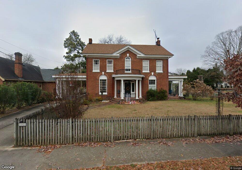
202 Raleigh Road Pkwy W Wilson, NC 27893
Estimated Value: $292,000 - $389,000
3
Beds
3
Baths
2,372
Sq Ft
$134/Sq Ft
Est. Value
About This Home
This home is located at 202 Raleigh Road Pkwy W, Wilson, NC 27893 and is currently estimated at $317,669, approximately $133 per square foot. 202 Raleigh Road Pkwy W is a home located in Wilson County with nearby schools including Wells Elementary School, Toisnot Middle School, and Fike High School.
Ownership History
Date
Name
Owned For
Owner Type
Purchase Details
Closed on
Dec 14, 2020
Sold by
Shori John and Shori Tannya
Bought by
London Roxanne
Current Estimated Value
Home Financials for this Owner
Home Financials are based on the most recent Mortgage that was taken out on this home.
Original Mortgage
$133,500
Outstanding Balance
$97,111
Interest Rate
2.8%
Mortgage Type
New Conventional
Estimated Equity
$220,558
Purchase Details
Closed on
May 24, 2016
Sold by
Pardue Mark William and Pardue Joyce Ann
Bought by
Short John and Short Tannya
Create a Home Valuation Report for This Property
The Home Valuation Report is an in-depth analysis detailing your home's value as well as a comparison with similar homes in the area
Home Values in the Area
Average Home Value in this Area
Purchase History
| Date | Buyer | Sale Price | Title Company |
|---|---|---|---|
| London Roxanne | $178,000 | None Available | |
| Short John | $160,000 | Attorney |
Source: Public Records
Mortgage History
| Date | Status | Borrower | Loan Amount |
|---|---|---|---|
| Open | London Roxanne | $133,500 |
Source: Public Records
Tax History Compared to Growth
Tax History
| Year | Tax Paid | Tax Assessment Tax Assessment Total Assessment is a certain percentage of the fair market value that is determined by local assessors to be the total taxable value of land and additions on the property. | Land | Improvement |
|---|---|---|---|---|
| 2025 | $2,978 | $265,871 | $47,250 | $218,621 |
| 2024 | $2,978 | $265,871 | $47,250 | $218,621 |
| 2023 | $2,354 | $180,399 | $27,000 | $153,399 |
| 2022 | $2,354 | $180,399 | $27,000 | $153,399 |
| 2021 | $2,354 | $161,853 | $27,000 | $134,853 |
| 2020 | $2,112 | $161,853 | $27,000 | $134,853 |
| 2019 | $0 | $161,853 | $27,000 | $134,853 |
| 2018 | $0 | $161,853 | $27,000 | $134,853 |
| 2017 | $2,080 | $161,853 | $27,000 | $134,853 |
| 2016 | $2,080 | $161,853 | $27,000 | $134,853 |
| 2014 | $1,790 | $143,802 | $27,000 | $116,802 |
Source: Public Records
Map
Nearby Homes
- 905 Nash St NW
- 1003 Branch St NW
- 1005 Anderson St NW
- 1103 Kenan St NW
- 900 Nash St N
- 310 Atlantic Christian College Dr W
- 806 Vance St N
- 703 Broad St W
- 704 Vance St E
- 909 Lee St N
- 1110 Vance St N
- 711 Kenan St W
- 1121 Vance St N
- 700 Kenan St W
- 1205 Gold St N
- 1209 Gold St N
- 416 Rountree St W
- 207 Bruton St W
- 1009 Walnut St W
- 701 Franklin Ave W
- 204 Raleigh Road Pkwy W
- 903 Anderson St NW
- 206 Raleigh Road Pkwy W
- 111 Raleigh Road Pkwy W
- 905 Anderson St NW
- 902 Branch St NW
- 203 Raleigh Road Pkwy W
- 907 Anderson St NW
- 906 Branch St NW
- 107&109 Raleigh Road Pkwy
- 906 Broad St W
- 913 Broad St W
- 107 Raleigh Road Pkwy W
- 107 Raleigh Road Pkwy W
- 908 Anderson St NW
- 909 NW Anderson St
- 211 Raleigh Road Pkwy W
- 909 Anderson St NW
- 908 Branch St NW
- 908 Branch St NW