T
Seller's Agent in 2026
Todd Walters
Prescott Real Estate Advisors
(928) 830-4162
86 Total Sales

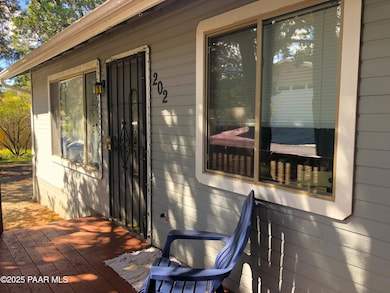
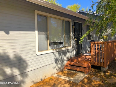

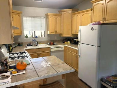
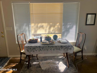
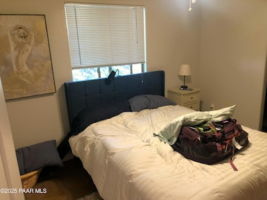
Excellent opportunity to own this great duplex with an incredibly convenient location to downtown, businesses, shopping and easy walking distance to the courthouse square to boot! Both units have a great rental history and are currently leased. The property is in excellent condition. Each unit has two bedrooms and one full bath with ample off street parking. Both units share a common laundry facility. Tenants pay all utilities. Roof was replaced in 2024. Come take a look at this duplex that's located in a nice neighborhood!
Last Agent to Sell the Property
Prescott Real Estate Advisors License #SA560605000 Listed on: 10/21/2025
Last Buyer's Agent
Better Homes And Gardens Real Estate Bloomtree Realty License #SA514281000

| Date | Type | Sale Price | Title Company |
|---|---|---|---|
| Warranty Deed | $487,000 | Yavapai Title Agency | |
| Special Warranty Deed | -- | Gadarian & Cacy Pllc | |
| Quit Claim Deed | -- | Timios | |
| Interfamily Deed Transfer | -- | None Available | |
| Interfamily Deed Transfer | -- | Capital Title Agency | |
| Warranty Deed | $250,000 | Capital Title Agency Inc |
| Date | Status | Loan Amount | Loan Type |
|---|---|---|---|
| Previous Owner | $148,000 | New Conventional | |
| Previous Owner | $185,000 | New Conventional |
| Date | Event | Price | List to Sale | Price per Sq Ft |
|---|---|---|---|---|
| 01/07/2026 01/07/26 | Sold | $487,000 | -2.4% | $301 / Sq Ft |
| 10/21/2025 10/21/25 | For Sale | $499,000 | -- | $308 / Sq Ft |
| Year | Tax Paid | Tax Assessment Tax Assessment Total Assessment is a certain percentage of the fair market value that is determined by local assessors to be the total taxable value of land and additions on the property. | Land | Improvement |
|---|---|---|---|---|
| 2026 | $1,264 | $32,986 | -- | -- |
| 2024 | $1,238 | $33,289 | -- | -- |
| 2023 | $1,238 | $26,198 | $4,348 | $21,850 |
| 2022 | $1,213 | $21,742 | $4,203 | $17,539 |
| 2021 | $1,265 | $21,989 | $3,959 | $18,030 |
| 2020 | $1,267 | $0 | $0 | $0 |
| 2019 | $1,251 | $0 | $0 | $0 |
| 2018 | $1,207 | $0 | $0 | $0 |
| 2017 | $1,151 | $0 | $0 | $0 |
| 2016 | $1,158 | $0 | $0 | $0 |
| 2015 | -- | $0 | $0 | $0 |
| 2014 | -- | $0 | $0 | $0 |
T
Seller's Agent in 2026
Todd Walters
Prescott Real Estate Advisors
(928) 830-4162
86 Total Sales
C
Buyer's Agent in 2026
Carie Banuelos
Better Homes And Gardens Real Estate Bloomtree Realty
(928) 710-7445
65 Total Sales
Source: Prescott Area Association of REALTORS®
MLS Number: 1077281
APN: 114-06-020B
Disclaimer: Certain information contained herein is derived from information provided by parties other than Homes.com. All information provided is deemed reliable, but is not guaranteed to be accurate and should be independently verified.
![]() Based on information submitted to the MLS GRID. All data is obtained from various sources and may not have been verified by broker or MLS GRID. Supplied Open House Information is subject to change without notice. All information should be independently reviewed and verified for accuracy. Properties may or may not be listed by the office/agent presenting the information. Some IDX listings have been excluded from this website. IDX information is provided exclusively for personal, non-commercial use, and may not be used for any purpose other than to identify prospective properties consumers may be interested in purchasing. Information is deemed reliable but not guaranteed.
Based on information submitted to the MLS GRID. All data is obtained from various sources and may not have been verified by broker or MLS GRID. Supplied Open House Information is subject to change without notice. All information should be independently reviewed and verified for accuracy. Properties may or may not be listed by the office/agent presenting the information. Some IDX listings have been excluded from this website. IDX information is provided exclusively for personal, non-commercial use, and may not be used for any purpose other than to identify prospective properties consumers may be interested in purchasing. Information is deemed reliable but not guaranteed.
Based on information submitted to the MLS GRID
Ask me questions while you tour the home.