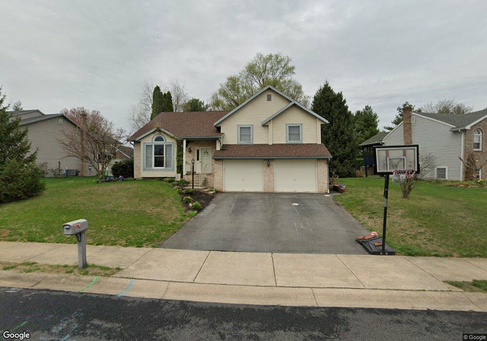
202 Roosevelt Cir Ephrata, PA 17522
Estimated Value: $397,274 - $453,000
4
Beds
3
Baths
2,140
Sq Ft
$198/Sq Ft
Est. Value
About This Home
This home is located at 202 Roosevelt Cir, Ephrata, PA 17522 and is currently estimated at $423,319, approximately $197 per square foot. 202 Roosevelt Cir is a home located in Lancaster County with nearby schools including Ephrata Intermediate School, Clay Elementary School, and Ephrata Senior High School.
Ownership History
Date
Name
Owned For
Owner Type
Purchase Details
Closed on
Apr 22, 2015
Sold by
Hession Michael T
Bought by
Hession Michael T and Winder Hession Veronica L
Current Estimated Value
Home Financials for this Owner
Home Financials are based on the most recent Mortgage that was taken out on this home.
Original Mortgage
$197,800
Outstanding Balance
$152,932
Interest Rate
3.86%
Mortgage Type
New Conventional
Estimated Equity
$270,387
Purchase Details
Closed on
May 15, 2009
Sold by
Witman Michael T
Bought by
Hession Michael T
Home Financials for this Owner
Home Financials are based on the most recent Mortgage that was taken out on this home.
Original Mortgage
$211,105
Interest Rate
5.43%
Mortgage Type
FHA
Create a Home Valuation Report for This Property
The Home Valuation Report is an in-depth analysis detailing your home's value as well as a comparison with similar homes in the area
Home Values in the Area
Average Home Value in this Area
Purchase History
| Date | Buyer | Sale Price | Title Company |
|---|---|---|---|
| Hession Michael T | -- | None Available | |
| Hession Michael T | $215,000 | None Available |
Source: Public Records
Mortgage History
| Date | Status | Borrower | Loan Amount |
|---|---|---|---|
| Open | Hession Michael T | $197,800 | |
| Previous Owner | Hession Michael T | $211,105 |
Source: Public Records
Tax History Compared to Growth
Tax History
| Year | Tax Paid | Tax Assessment Tax Assessment Total Assessment is a certain percentage of the fair market value that is determined by local assessors to be the total taxable value of land and additions on the property. | Land | Improvement |
|---|---|---|---|---|
| 2025 | $4,450 | $194,300 | $50,600 | $143,700 |
| 2024 | $4,450 | $194,300 | $50,600 | $143,700 |
| 2023 | $4,335 | $194,300 | $50,600 | $143,700 |
| 2022 | $4,236 | $194,300 | $50,600 | $143,700 |
| 2021 | $4,145 | $194,300 | $50,600 | $143,700 |
| 2020 | $4,145 | $194,300 | $50,600 | $143,700 |
| 2019 | $4,086 | $194,300 | $50,600 | $143,700 |
| 2018 | $4,865 | $194,300 | $50,600 | $143,700 |
| 2017 | $4,473 | $175,500 | $51,800 | $123,700 |
| 2016 | $4,473 | $175,500 | $51,800 | $123,700 |
| 2015 | $884 | $175,500 | $51,800 | $123,700 |
| 2014 | $3,313 | $175,500 | $51,800 | $123,700 |
Source: Public Records
Map
Nearby Homes
- 124 Morning Dr
- 00 Morning Dr
- 57 Perseverance Ln
- 131 Sunrise Ln
- 144 Sunrise Ln
- Amberbrook Plan at Wyndale
- Northfield Plan at Wyndale
- Logan Plan at Wyndale
- Stonecroft Plan at Wyndale
- Darien Plan at Wyndale
- Atworth Plan at Wyndale
- Magnolia Plan at Wyndale
- Baker Plan at Wyndale
- Huntington Plan at Wyndale
- Westbrooke Plan at Wyndale
- Perry Plan at Wyndale
- Charlotte Plan at Wyndale
- Kingston Plan at Wyndale
- Brookfield Plan at Wyndale
- Silverbrooke Plan at Wyndale
- 204 Roosevelt Cir
- 200 Roosevelt Cir
- 443 Countryside Dr
- 206 Roosevelt Cir
- 441 Countryside Dr
- 501 Countryside Dr
- 203 Roosevelt Cir
- 205 Roosevelt Cir
- 355 Woodchuck Dr
- 207 Roosevelt Cir
- 444 Countryside Dr
- 442 Countryside Dr
- 208 Roosevelt Cir
- 360 Woodchuck Dr
- 439 Countryside Dr
- 209 Roosevelt Cir
- 503 Countryside Dr
- 502 Countryside Dr
- 660 Lincoln Gardens Rd
- 670 Lincoln Gardens Rd