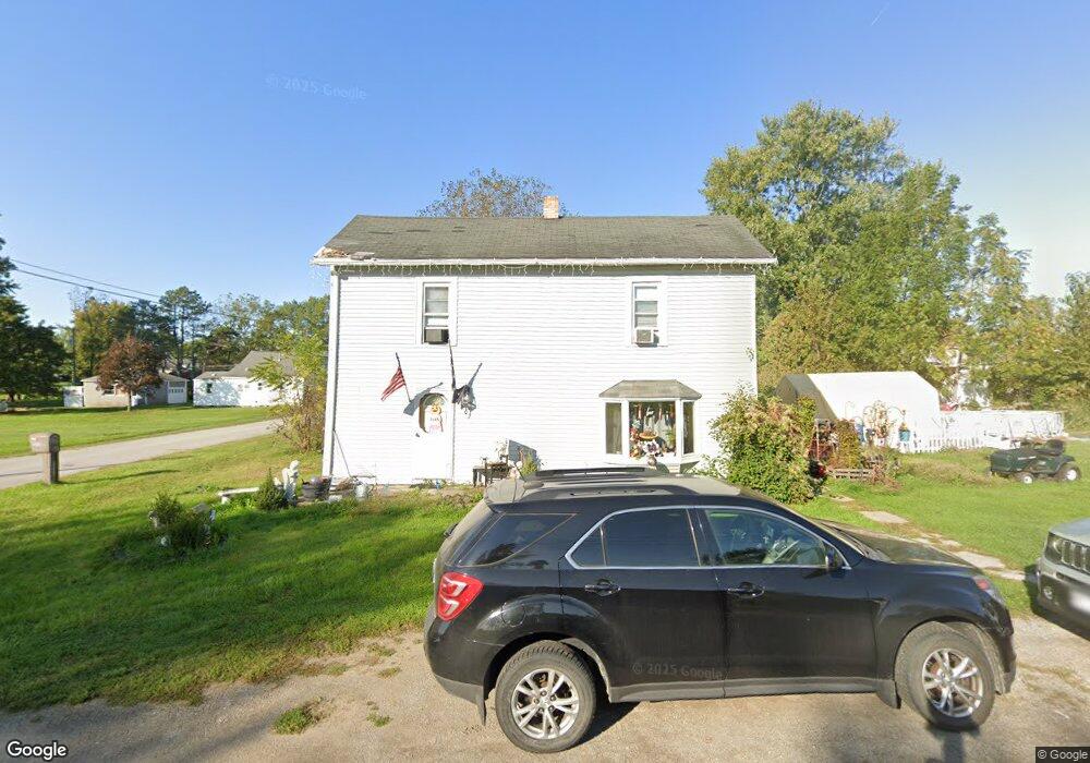
202 S Earl St Waynesfield, OH 45896
Estimated Value: $70,000 - $143,000
4
Beds
1
Bath
1,408
Sq Ft
$79/Sq Ft
Est. Value
About This Home
This home is located at 202 S Earl St, Waynesfield, OH 45896 and is currently estimated at $111,238, approximately $79 per square foot. 202 S Earl St is a home located in Auglaize County with nearby schools including Waynesfield-Goshen Local Elementary School and Waynesfield-Goshen Local High School.
Ownership History
Date
Name
Owned For
Owner Type
Purchase Details
Closed on
Jun 14, 2021
Sold by
Shobe Sheldon G
Bought by
Kuhn Karen J
Current Estimated Value
Home Financials for this Owner
Home Financials are based on the most recent Mortgage that was taken out on this home.
Original Mortgage
$41,239
Outstanding Balance
$37,337
Interest Rate
2.9%
Mortgage Type
FHA
Estimated Equity
$73,901
Purchase Details
Closed on
Dec 14, 2012
Sold by
Federal Home Loan Mortgage Corporation
Bought by
Shobe Sheldon G
Purchase Details
Closed on
Oct 1, 2012
Sold by
Eastman Brent R and Eastman Misty A
Bought by
Federal Home Loan Mortgage Corporation
Purchase Details
Closed on
Jun 14, 2001
Sold by
Caudill Constance Lynn
Bought by
Eastman Brent R
Create a Home Valuation Report for This Property
The Home Valuation Report is an in-depth analysis detailing your home's value as well as a comparison with similar homes in the area
Home Values in the Area
Average Home Value in this Area
Purchase History
| Date | Buyer | Sale Price | Title Company |
|---|---|---|---|
| Kuhn Karen J | $42,000 | First Lima Title | |
| Shobe Sheldon G | $14,000 | Intitle Agency Inc | |
| Federal Home Loan Mortgage Corporation | $28,000 | None Available | |
| Eastman Brent R | $52,000 | -- |
Source: Public Records
Mortgage History
| Date | Status | Borrower | Loan Amount |
|---|---|---|---|
| Open | Kuhn Karen J | $41,239 |
Source: Public Records
Tax History Compared to Growth
Tax History
| Year | Tax Paid | Tax Assessment Tax Assessment Total Assessment is a certain percentage of the fair market value that is determined by local assessors to be the total taxable value of land and additions on the property. | Land | Improvement |
|---|---|---|---|---|
| 2024 | $1,735 | $26,810 | $3,010 | $23,800 |
| 2023 | $990 | $26,810 | $3,010 | $23,800 |
| 2022 | $790 | $17,860 | $2,800 | $15,060 |
| 2021 | $792 | $17,860 | $2,800 | $15,060 |
| 2020 | $781 | $17,864 | $2,800 | $15,064 |
| 2019 | $638 | $14,890 | $2,335 | $12,555 |
| 2018 | $624 | $14,890 | $2,335 | $12,555 |
| 2017 | $622 | $14,890 | $2,335 | $12,555 |
| 2016 | $619 | $15,289 | $2,223 | $13,066 |
| 2015 | $321 | $15,289 | $2,223 | $13,066 |
| 2014 | $620 | $15,289 | $2,223 | $13,066 |
| 2013 | $685 | $15,289 | $2,223 | $13,066 |
Source: Public Records
Map
Nearby Homes
- 25836 Ohio 67
- 202 W Mulberry St
- 105 Guthrie St
- 22275 Buckland Holden Rd
- 8150 Amherst Rd
- 5065 Amherst Rd
- 20630 State Route 67
- 17 E Walnut St
- 37 N Main St
- 0 Ohio 67
- 7165 Faulkner Rd
- 11352 N Township Road 88
- 6616 Bellefontaine Rd
- 12102 Shannon Dr Unit 89
- 6381 McPheron Rd
- 12015 Holly Dr
- 11773 Sunview Ave
- 11579 Cooper Ave
- 13793 Ohio 235 Unit 75
- 11161 Macalpine Way