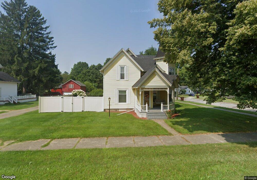
202 S Main St Concord, MI 49237
Estimated Value: $160,669 - $210,000
Studio
--
Bath
1,676
Sq Ft
$112/Sq Ft
Est. Value
About This Home
This home is located at 202 S Main St, Concord, MI 49237 and is currently estimated at $187,167, approximately $111 per square foot. 202 S Main St is a home located in Jackson County with nearby schools including Concord Elementary School, Concord Middle School, and Concord High School.
Ownership History
Date
Name
Owned For
Owner Type
Purchase Details
Closed on
Feb 27, 2017
Sold by
Vick Gale L
Bought by
Vick Mark E
Current Estimated Value
Purchase Details
Closed on
Oct 20, 2000
Sold by
Citizens Bank
Bought by
Vick Mark E and Vick Gale L
Home Financials for this Owner
Home Financials are based on the most recent Mortgage that was taken out on this home.
Original Mortgage
$77,000
Outstanding Balance
$28,041
Interest Rate
7.9%
Estimated Equity
$159,126
Purchase Details
Closed on
Oct 29, 1996
Sold by
Sneary Richard E and Sneary Loriene M
Bought by
Knaub Paul E and Knaub Kimberly K
Purchase Details
Closed on
Jul 1, 1992
Bought by
Sneary
Create a Home Valuation Report for This Property
The Home Valuation Report is an in-depth analysis detailing your home's value as well as a comparison with similar homes in the area
Purchase History
| Date | Buyer | Sale Price | Title Company |
|---|---|---|---|
| Vick Mark E | -- | None Available | |
| Vick Mark E | $87,000 | -- | |
| Knaub Paul E | $92,500 | -- | |
| Sneary | -- | -- |
Source: Public Records
Mortgage History
| Date | Status | Borrower | Loan Amount |
|---|---|---|---|
| Open | Vick Mark E | $77,000 |
Source: Public Records
Tax History
| Year | Tax Paid | Tax Assessment Tax Assessment Total Assessment is a certain percentage of the fair market value that is determined by local assessors to be the total taxable value of land and additions on the property. | Land | Improvement |
|---|---|---|---|---|
| 2025 | $1,522 | $75,900 | $75,900 | $0 |
| 2024 | $12 | $74,100 | $74,100 | $0 |
| 2023 | $1,126 | $67,500 | $67,500 | $0 |
| 2022 | $1,987 | $65,800 | $65,800 | $0 |
| 2021 | $1,955 | $55,800 | $55,800 | $0 |
| 2020 | $1,935 | $50,800 | $0 | $0 |
| 2019 | $1,888 | $51,000 | $0 | $0 |
| 2018 | $1,278 | $45,400 | $0 | $0 |
| 2017 | $1,146 | $42,700 | $0 | $0 |
| 2016 | $416 | $45,300 | $45,300 | $0 |
| 2015 | -- | $36,950 | $36,950 | $0 |
| 2014 | -- | $38,000 | $38,000 | $0 |
| 2013 | -- | $38,000 | $38,000 | $0 |
Source: Public Records
Map
Nearby Homes
- 0 River Bend Drive Lot #11
- 0 River Bend Drive Lot #4
- 0 River Bend Drive Lot #3
- 0 River Bend Drive Lot #5
- 0 River Bend Drive Lot #9
- 0 River Bend Drive Lot #10
- 190 Maple St
- 229 S Concord St
- 316 Monroe St
- 213 Railroad St
- 313 Michigan St
- 125 Coxon St
- 516 Cecil Dr
- 731 Sears Rd
- 0 Albion Rd
- 201 Lake Hills Dr
- 270 Wood Hills Dr
- 7210 Pulaski Rd Rd
- 0 River Bend Drive Lot #1
- 0 River Bend Drive Lot #2
Your Personal Tour Guide
Ask me questions while you tour the home.