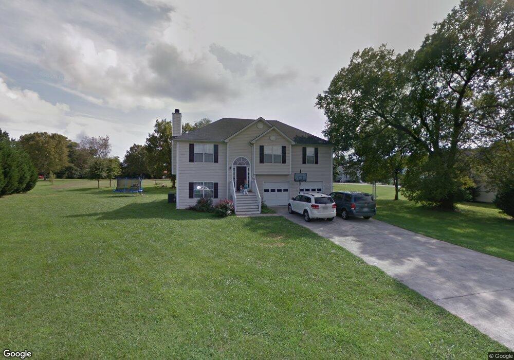
202 Station Way Adairsville, GA 30103
Estimated Value: $261,000 - $285,000
3
Beds
2
Baths
1,264
Sq Ft
$218/Sq Ft
Est. Value
About This Home
This home is located at 202 Station Way, Adairsville, GA 30103 and is currently estimated at $275,926, approximately $218 per square foot. 202 Station Way is a home located in Bartow County with nearby schools including Clear Creek Elementary School, Adairsville Middle School, and Adairsville High School.
Ownership History
Date
Name
Owned For
Owner Type
Purchase Details
Closed on
Apr 30, 2010
Sold by
Ferrell Charles E
Bought by
Barnette Alaina E
Current Estimated Value
Home Financials for this Owner
Home Financials are based on the most recent Mortgage that was taken out on this home.
Original Mortgage
$84,693
Outstanding Balance
$56,794
Interest Rate
5.06%
Mortgage Type
New Conventional
Estimated Equity
$219,132
Purchase Details
Closed on
Nov 29, 2006
Sold by
Ferrell Charles E
Bought by
Ferrell Charles E
Create a Home Valuation Report for This Property
The Home Valuation Report is an in-depth analysis detailing your home's value as well as a comparison with similar homes in the area
Home Values in the Area
Average Home Value in this Area
Purchase History
| Date | Buyer | Sale Price | Title Company |
|---|---|---|---|
| Barnette Alaina E | $83,000 | -- | |
| Ferrell Charles E | -- | -- |
Source: Public Records
Mortgage History
| Date | Status | Borrower | Loan Amount |
|---|---|---|---|
| Open | Barnette Alaina E | $84,693 |
Source: Public Records
Tax History Compared to Growth
Tax History
| Year | Tax Paid | Tax Assessment Tax Assessment Total Assessment is a certain percentage of the fair market value that is determined by local assessors to be the total taxable value of land and additions on the property. | Land | Improvement |
|---|---|---|---|---|
| 2024 | $2,527 | $100,976 | $20,000 | $80,976 |
| 2023 | $2,527 | $92,078 | $20,000 | $72,078 |
| 2022 | $2,061 | $78,677 | $16,000 | $62,677 |
| 2021 | $1,712 | $63,467 | $16,000 | $47,467 |
| 2020 | $1,814 | $63,467 | $16,000 | $47,467 |
| 2019 | $1,719 | $59,102 | $16,000 | $43,102 |
| 2018 | $1,525 | $52,509 | $10,000 | $42,509 |
| 2017 | $1,533 | $52,509 | $10,000 | $42,509 |
| 2016 | $1,223 | $42,680 | $6,000 | $36,680 |
| 2015 | $1,125 | $39,440 | $4,000 | $35,440 |
| 2014 | $1,110 | $38,080 | $6,000 | $32,080 |
| 2013 | -- | $34,760 | $6,400 | $28,360 |
Source: Public Records
Map
Nearby Homes
- 141 Village Green Dr NW
- 111 Village Green Dr NW
- 111 Village Green Dr NW Unit 168
- 109 Village Green Dr NW
- 107 Village Green Dr NW
- 107 Village Green Dr NW Unit 170
- 105 Village Green Dr NW
- 105 Village Green Dr NW Unit 171
- Oleander Plan at Village Green - Bungalow Series
- Crape Myrtle Plan at Village Green - Bungalow Series
- 311 Rolling Green Dr NW
- 313 Rolling Green Dr NW
- 315 Rolling Green Dr NW
- 317 Rolling Green Dr NW
- 323 Rolling Green Dr NW
- 103 Heritage Dr NW
- 699 Old Highway 41 NW
- Chatsworth Plan at Maple Village - Georgian Series
- Hawthorne Plan at Maple Village - Bungalow Series
- Linden Plan at Maple Village - Bungalow Series
- 200 Station Way
- 0 Manning Mill
- 129 Manning Mill Rd NW
- 204 Station Way
- 1 Court Crossing
- 0 Court Crossing Unit 7006170
- 0 Court Crossing Unit 8662909
- 0 Court Crossing Unit 8629176
- 0 Court Crossing Unit 8121142
- 0 Court Crossing Unit 8043918
- 0 Court Crossing
- 206 Station Way
- 131 Manning Mill Rd NW
- 203 Station Way
- 126 Manning Mill Rd NW Unit ID1234823P
- 126 Manning Mill Rd NW
- 3 Court Crossing
- 201 Station Way
- 128 Manning Mill Rd NW
- 124 Manning Mill Rd NW