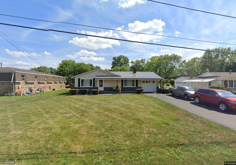
202 Taff Cir Louisville, OH 44641
Estimated Value: $192,000 - $224,000
3
Beds
2
Baths
1,298
Sq Ft
$162/Sq Ft
Est. Value
About This Home
This home is located at 202 Taff Cir, Louisville, OH 44641 and is currently estimated at $210,743, approximately $162 per square foot. 202 Taff Cir is a home located in Stark County with nearby schools including Louisville High School and St. Thomas Aquinas High School & Middle School.
Ownership History
Date
Name
Owned For
Owner Type
Purchase Details
Closed on
Apr 19, 2021
Sold by
Mayle Rocky J and Mayle Michelle Megan
Bought by
Mayle Rocky J and Mayle Megan Michelle
Current Estimated Value
Home Financials for this Owner
Home Financials are based on the most recent Mortgage that was taken out on this home.
Original Mortgage
$100,700
Interest Rate
3%
Mortgage Type
New Conventional
Purchase Details
Closed on
Aug 23, 2006
Sold by
Fitzsimmons Patricia A
Bought by
Mayle Rocky J
Home Financials for this Owner
Home Financials are based on the most recent Mortgage that was taken out on this home.
Original Mortgage
$82,400
Interest Rate
9.33%
Mortgage Type
Purchase Money Mortgage
Purchase Details
Closed on
Apr 18, 2006
Sold by
Estate Of Cecil R Fitzsimmons
Bought by
Fitzsimmons Patricia A
Create a Home Valuation Report for This Property
The Home Valuation Report is an in-depth analysis detailing your home's value as well as a comparison with similar homes in the area
Home Values in the Area
Average Home Value in this Area
Purchase History
| Date | Buyer | Sale Price | Title Company |
|---|---|---|---|
| Mayle Rocky J | -- | Diaz Anselmo Lindberg Pa | |
| Mayle Rocky J | $103,000 | Netwide Title Agency Inc | |
| Fitzsimmons Patricia A | -- | None Available |
Source: Public Records
Mortgage History
| Date | Status | Borrower | Loan Amount |
|---|---|---|---|
| Previous Owner | Mayle Rocky J | $100,700 | |
| Previous Owner | Mayle Rocky J | $82,400 |
Source: Public Records
Tax History Compared to Growth
Tax History
| Year | Tax Paid | Tax Assessment Tax Assessment Total Assessment is a certain percentage of the fair market value that is determined by local assessors to be the total taxable value of land and additions on the property. | Land | Improvement |
|---|---|---|---|---|
| 2025 | -- | $61,190 | $15,370 | $45,820 |
| 2024 | -- | $61,190 | $15,370 | $45,820 |
| 2023 | $2,186 | $50,860 | $15,230 | $35,630 |
| 2022 | $2,192 | $50,860 | $15,230 | $35,630 |
| 2021 | $2,198 | $50,860 | $15,230 | $35,630 |
| 2020 | $1,809 | $45,470 | $13,720 | $31,750 |
| 2019 | $1,817 | $38,260 | $13,720 | $24,540 |
| 2018 | $1,524 | $38,260 | $13,720 | $24,540 |
| 2017 | $1,383 | $33,500 | $11,200 | $22,300 |
| 2016 | $1,411 | $33,500 | $11,200 | $22,300 |
| 2015 | $1,416 | $33,500 | $11,200 | $22,300 |
| 2014 | $1,314 | $28,910 | $9,660 | $19,250 |
| 2013 | $661 | $28,910 | $9,660 | $19,250 |
Source: Public Records
Map
Nearby Homes
- 1702 View Pointe Ave
- 1639 Horizon Dr
- 908 Sand Lot Cir
- 510 S Bauman Ct
- 204 E Broad St
- 107 E Broad St
- 728 E Broad St
- 520 S Silver St
- 641 S Nickelplate St
- 308 Superior St
- 1715 High St
- 325 Lincoln Ave
- 8225 Georgetown St
- 1812 E Broad St
- 201 Indiana Ave
- 2110 Edmar St
- 0 Michigan Blvd
- 6969 Georgetown St NE
- 248 Menegay Rd
- 3390 Meese Rd NE
- 110 Taff Cir
- 210 Taff Cir
- 210 Taff Cir Unit B
- 210 Taff Cir Unit A
- 210 Taff Cir Unit C
- 216 Taff Cir
- 216 Taff Cir Unit C
- 216 Taff Cir Unit A
- 216 Taff Cir Unit B
- 102 Taff Cir
- 205 Beechwood St
- 1524 S Chapel St
- 302 1123
- 302 Taff Cir
- 302 Taff Cir Unit C
- 119 Taff Cir
- 107 Taff Cir
- 1534 S Chapel St
- 312 Taff Cir
- 213 Beechwood St