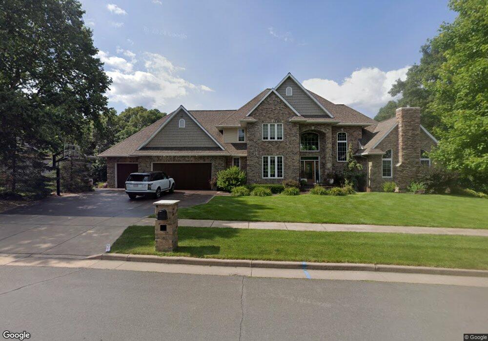
2020 High Point Dr Altoona, WI 54720
Estimated Value: $520,000 - $822,530
4
Beds
5
Baths
5,000
Sq Ft
$138/Sq Ft
Est. Value
About This Home
This home is located at 2020 High Point Dr, Altoona, WI 54720 and is currently estimated at $688,883, approximately $137 per square foot. 2020 High Point Dr is a home with nearby schools including Altoona Elementary School, Altoona Middle and Intermediate School, and Altoona High School.
Ownership History
Date
Name
Owned For
Owner Type
Purchase Details
Closed on
Jul 8, 2008
Sold by
Seebruck Michael C and Seebruck Nancy J
Bought by
Tambronino Curt J and Tambronino Tammy L
Current Estimated Value
Home Financials for this Owner
Home Financials are based on the most recent Mortgage that was taken out on this home.
Original Mortgage
$384,000
Outstanding Balance
$251,346
Interest Rate
6.36%
Mortgage Type
New Conventional
Estimated Equity
$437,537
Purchase Details
Closed on
Apr 1, 2005
Sold by
Kriesel Brian
Bought by
Seebruck Michael C
Create a Home Valuation Report for This Property
The Home Valuation Report is an in-depth analysis detailing your home's value as well as a comparison with similar homes in the area
Home Values in the Area
Average Home Value in this Area
Purchase History
| Date | Buyer | Sale Price | Title Company |
|---|---|---|---|
| Tambronino Curt J | $480,000 | None Available | |
| Seebruck Michael C | $5,100 | None Available | |
| Seebruck Michael C | $5,100 | None Available |
Source: Public Records
Mortgage History
| Date | Status | Borrower | Loan Amount |
|---|---|---|---|
| Open | Tambronino Curt J | $384,000 |
Source: Public Records
Tax History Compared to Growth
Tax History
| Year | Tax Paid | Tax Assessment Tax Assessment Total Assessment is a certain percentage of the fair market value that is determined by local assessors to be the total taxable value of land and additions on the property. | Land | Improvement |
|---|---|---|---|---|
| 2024 | $12,590 | $847,200 | $70,800 | $776,400 |
| 2023 | $13,568 | $779,700 | $70,800 | $708,900 |
| 2022 | $13,063 | $779,700 | $70,800 | $708,900 |
| 2021 | $12,335 | $614,800 | $64,400 | $550,400 |
| 2020 | $12,496 | $614,800 | $64,400 | $550,400 |
| 2019 | $12,003 | $614,800 | $64,400 | $550,400 |
| 2018 | $11,568 | $519,400 | $69,000 | $450,400 |
| 2017 | $11,483 | $519,400 | $69,000 | $450,400 |
| 2016 | $11,485 | $519,400 | $69,000 | $450,400 |
| 2014 | -- | $519,400 | $69,000 | $450,400 |
| 2013 | -- | $519,400 | $69,000 | $450,400 |
Source: Public Records
Map
Nearby Homes
- 928 Thompson Dr
- 2037 Saint Andrews Dr
- 1923 Saint Andrews Dr
- 1804 Bartlett Ave
- 1364 Cypress Ct
- 2505 Avery Ln
- 1412 Devney Dr
- 2364 St Andrews Dr
- 0 Roberts St
- Lot 179 Pebble Beach Dr
- 1410 Pebble Beach Dr Unit Lot 161
- 1285 Saint Andrews Dr Unit Lot 147
- 1372 Pebble Beach Dr Unit Lot 163
- 1650 Kyler St
- 457 Autumn Dr
- 911 Radcliffe Ave
- 3916 Harless Rd
- 3931 Harless Rd
- 4240 Clay St
- 1103 Mulberry Dr
- 2028 High Point Dr
- 2008 High Point Dr
- 2021 High Point Dr
- 2104 High Point Dr
- 2103 High Point Dr
- 2004 High Point Dr
- 2111 High Point Dr
- 2112 High Point Dr
- 2112 Hillside Rd
- 1928 High Point Dr
- 2120 High Point Dr
- 2119 High Point Dr
- 1920 High Point Dr
- 903 7th St W
- 2128 High Point Dr
- 2211 Hillside Rd
- 920 7th St W
- 2127 High Point Dr
- 2123 High Point Dr
- 2204 Hillside Rd