Estimated Value: $355,313 - $395,000
3
Beds
2
Baths
1,642
Sq Ft
$224/Sq Ft
Est. Value
About This Home
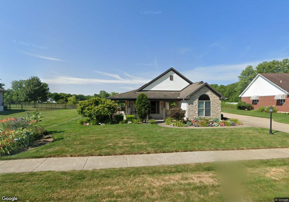
This home is located at 2020 Kitty Hawk Dr, Xenia, OH 45385 and is currently estimated at $367,328, approximately $223 per square foot. 2020 Kitty Hawk Dr is a home located in Greene County with nearby schools including Xenia High School, Summit Academy Community School for Alternative Learners - Xenia, and Legacy Christian Academy.
Ownership History
Date
Name
Owned For
Owner Type
Purchase Details
Closed on
Oct 24, 2002
Sold by
P F D Development Pll
Bought by
Moore Ronald B and Moore Patricia L
Current Estimated Value
Home Financials for this Owner
Home Financials are based on the most recent Mortgage that was taken out on this home.
Original Mortgage
$197,500
Interest Rate
6.29%
Mortgage Type
Construction
Create a Home Valuation Report for This Property
The Home Valuation Report is an in-depth analysis detailing your home's value as well as a comparison with similar homes in the area
Home Values in the Area
Average Home Value in this Area
Purchase History
| Date | Buyer | Sale Price | Title Company |
|---|---|---|---|
| Moore Ronald B | $39,500 | -- |
Source: Public Records
Mortgage History
| Date | Status | Borrower | Loan Amount |
|---|---|---|---|
| Closed | Moore Ronald B | $197,500 |
Source: Public Records
Tax History Compared to Growth
Tax History
| Year | Tax Paid | Tax Assessment Tax Assessment Total Assessment is a certain percentage of the fair market value that is determined by local assessors to be the total taxable value of land and additions on the property. | Land | Improvement |
|---|---|---|---|---|
| 2024 | $4,188 | $100,280 | $19,740 | $80,540 |
| 2023 | $4,188 | $100,280 | $19,740 | $80,540 |
| 2022 | $3,763 | $76,800 | $13,160 | $63,640 |
| 2021 | $3,814 | $76,800 | $13,160 | $63,640 |
| 2020 | $3,651 | $76,800 | $13,160 | $63,640 |
| 2019 | $3,439 | $68,120 | $15,740 | $52,380 |
| 2018 | $3,446 | $68,120 | $15,740 | $52,380 |
| 2017 | $3,302 | $68,120 | $15,740 | $52,380 |
| 2016 | $3,303 | $63,950 | $15,740 | $48,210 |
| 2015 | $3,312 | $63,950 | $15,740 | $48,210 |
| 2014 | $3,168 | $63,950 | $15,740 | $48,210 |
Source: Public Records
Map
Nearby Homes
- 2144 Tandem Dr
- 2223 Tandem Dr
- 2096 High Wheel Dr
- 2540 Cornwall Dr
- 0 Berkshire Dr Unit 942854
- 2540 Jenny Marie Dr
- 2499 Jenny Marie Dr
- 2421 Louisiana Dr
- 2187 Minnesota Dr
- 1255 Colorado Dr
- 2265 Minnesota Dr
- 1881 Commonwealth Dr
- 2852 Raxit Ct
- 1908 Whitt St
- 2189 Mississippi Dr
- 2685 Childers Dr
- 1068 Hedges Rd
- 2705 Tennessee Dr
- 1248 Prem Place
- 2692 Kingman Dr
- 2010 Kitty Hawk Dr
- 2030 Kitty Hawk Dr
- 1989 Kitty Hawk Dr
- 2029 Kitty Hawk Dr
- 2000 Kitty Hawk Dr
- 2040 Kitty Hawk Dr
- 1978 Lakeview Dr
- 1990 Kitty Hawk Dr
- 2010 Lakeview Dr
- 1980 Kitty Hawk Dr
- Lot # 165 Lakeview Dr
- lot # 203 Lakeview Dr
- lot #201 Lakeview Dr
- lot #193 Lakeview Dr
- lot # 192 Lakeview Dr
- lot # 191 Lakeview Dr
- lot # 190 Lakeview Dr
- lot # 189 Lakeview Dr
- lot # 187 Lakeview Dr
- lot#186 Lakeview Dr