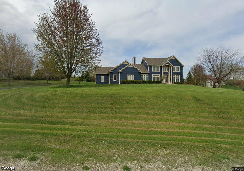
2020 Rolling Ridge Dr West Bend, WI 53090
Estimated Value: $594,000 - $787,000
--
Bed
--
Bath
--
Sq Ft
1.16
Acres
About This Home
This home is located at 2020 Rolling Ridge Dr, West Bend, WI 53090 and is currently estimated at $697,715. 2020 Rolling Ridge Dr is a home located in Washington County with nearby schools including Kewaskum High School.
Ownership History
Date
Name
Owned For
Owner Type
Purchase Details
Closed on
Mar 31, 2015
Sold by
Spykstra Todd A and Spykstra Jacqueline A
Bought by
Light James M and Light Adrianne M
Current Estimated Value
Home Financials for this Owner
Home Financials are based on the most recent Mortgage that was taken out on this home.
Original Mortgage
$340,159
Outstanding Balance
$261,008
Interest Rate
3.73%
Mortgage Type
VA
Estimated Equity
$436,707
Create a Home Valuation Report for This Property
The Home Valuation Report is an in-depth analysis detailing your home's value as well as a comparison with similar homes in the area
Home Values in the Area
Average Home Value in this Area
Purchase History
| Date | Buyer | Sale Price | Title Company |
|---|---|---|---|
| Light James M | $333,000 | None Available |
Source: Public Records
Mortgage History
| Date | Status | Borrower | Loan Amount |
|---|---|---|---|
| Open | Light James M | $340,159 |
Source: Public Records
Tax History Compared to Growth
Tax History
| Year | Tax Paid | Tax Assessment Tax Assessment Total Assessment is a certain percentage of the fair market value that is determined by local assessors to be the total taxable value of land and additions on the property. | Land | Improvement |
|---|---|---|---|---|
| 2024 | $4,780 | $414,000 | $48,200 | $365,800 |
| 2023 | $4,775 | $414,000 | $48,200 | $365,800 |
| 2022 | $4,417 | $414,000 | $48,200 | $365,800 |
| 2021 | $4,667 | $414,000 | $48,200 | $365,800 |
| 2020 | $4,720 | $414,000 | $48,200 | $365,800 |
| 2019 | $4,731 | $414,000 | $48,200 | $365,800 |
| 2018 | $4,557 | $414,000 | $48,200 | $365,800 |
| 2017 | $4,290 | $385,600 | $48,200 | $337,400 |
| 2016 | $4,176 | $385,600 | $48,200 | $337,400 |
| 2015 | $4,352 | $385,600 | $48,200 | $337,400 |
| 2014 | $4,352 | $385,600 | $48,200 | $337,400 |
| 2013 | $4,870 | $385,600 | $48,200 | $337,400 |
Source: Public Records
Map
Nearby Homes
- 7855 Indian Lore Rd
- 8451 Wesley Ct
- 1814 County H
- 2161 Wallace Lake Rd
- Lt4 Wallace Lake Rd
- 8414 Orchard Valley Rd
- Lt1 Orchard Valley Rd
- LT4 River Rd
- 2951 Glen Ivy Dr
- 7434 Werner Rd
- 7297 Salisbury Rd
- 1650 Vivian Ct
- 1606 Vivian Ct
- 1118 Harbor Ct
- 1110 Harbor Ct
- 1102 Harbor Ct
- 1072 Harbor Ct
- Lt2 N River Rd
- Lt1 N River Rd
- Lt3 N River Rd
- 2034 Rolling Ridge Dr
- 1987 Covey Place
- 1977 Covey Place
- 2002 Rolling Ridge Dr
- 2025 Rolling Ridge Dr
- 1995 Covey Place
- 2048 Rolling Ridge Dr
- 2009 Rolling Ridge Dr
- 1990 Covey Place
- 2071 Shalom Dr
- 1974 Covey Place
- 1999 Covey Place
- 1963 Covey Place
- 2055 Rolling Ridge Dr
- Lt9 Covey Place
- 1960 Covey Place
- 1983 Rolling Ridge Dr
- 8044 State Road 144 N
- 1954 Covey Place
- 8030 State Road 144 N