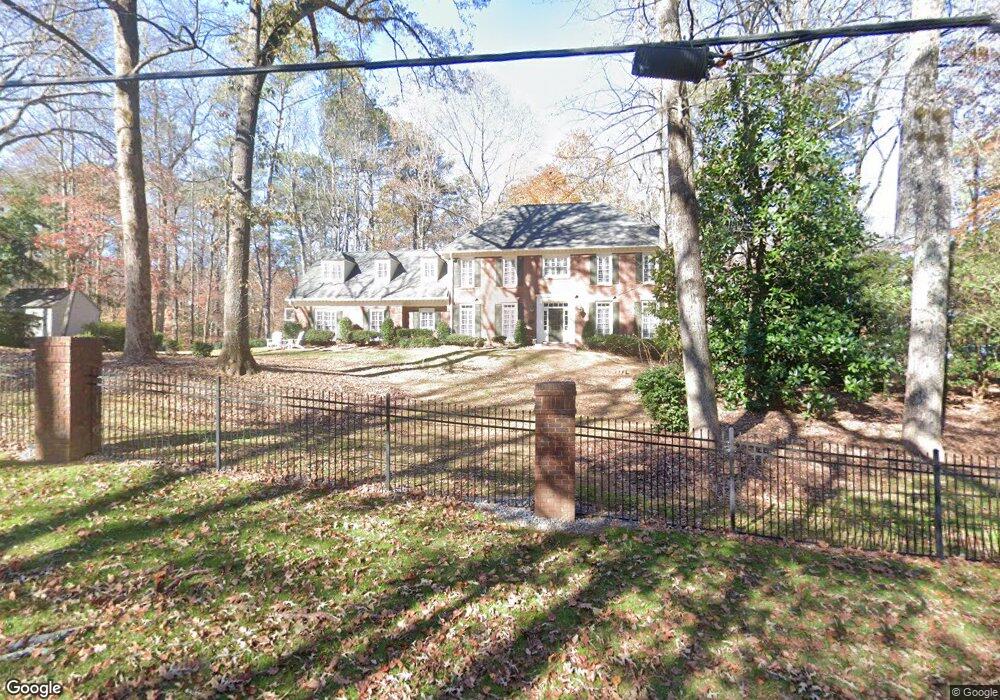
2020 Spalding Dr Unit 1 Atlanta, GA 30350
Dunwoody Panhandle NeighborhoodEstimated Value: $830,000 - $1,211,000
4
Beds
5
Baths
3,250
Sq Ft
$300/Sq Ft
Est. Value
About This Home
This home is located at 2020 Spalding Dr Unit 1, Atlanta, GA 30350 and is currently estimated at $975,233, approximately $300 per square foot. 2020 Spalding Dr Unit 1 is a home located in Fulton County with nearby schools including Dunwoody Springs Elementary School, Sandy Springs Middle School, and North Springs High School.
Ownership History
Date
Name
Owned For
Owner Type
Purchase Details
Closed on
Dec 30, 2020
Sold by
Federer Joseph P
Bought by
Federer Joseph Paul and Federer Family Liv Tr
Current Estimated Value
Purchase Details
Closed on
Apr 27, 2005
Sold by
Williams Cyd C
Bought by
Federer Joseph P and Federer R
Purchase Details
Closed on
Nov 24, 2004
Sold by
Williams Sylvester E
Bought by
Williams Cyd C
Purchase Details
Closed on
Feb 2, 1993
Sold by
Forst Laurie J
Bought by
Mellon Bank
Create a Home Valuation Report for This Property
The Home Valuation Report is an in-depth analysis detailing your home's value as well as a comparison with similar homes in the area
Home Values in the Area
Average Home Value in this Area
Purchase History
| Date | Buyer | Sale Price | Title Company |
|---|---|---|---|
| Federer Joseph Paul | -- | -- | |
| Federer Joseph P | $480,000 | -- | |
| Williams Cyd C | $215,000 | -- | |
| Mellon Bank | $286,300 | -- |
Source: Public Records
Tax History Compared to Growth
Tax History
| Year | Tax Paid | Tax Assessment Tax Assessment Total Assessment is a certain percentage of the fair market value that is determined by local assessors to be the total taxable value of land and additions on the property. | Land | Improvement |
|---|---|---|---|---|
| 2025 | $6,965 | $312,520 | $106,640 | $205,880 |
| 2023 | $8,821 | $312,520 | $106,640 | $205,880 |
| 2022 | $6,592 | $312,520 | $106,640 | $205,880 |
| 2021 | $6,554 | $303,400 | $103,520 | $199,880 |
| 2020 | $5,954 | $217,240 | $54,040 | $163,200 |
| 2019 | $5,864 | $213,360 | $53,080 | $160,280 |
| 2018 | $6,454 | $208,360 | $51,840 | $156,520 |
| 2017 | $5,246 | $167,080 | $36,160 | $130,920 |
| 2016 | $5,245 | $167,080 | $36,160 | $130,920 |
| 2015 | $5,263 | $167,080 | $36,160 | $130,920 |
| 2014 | $5,450 | $167,080 | $36,160 | $130,920 |
Source: Public Records
Map
Nearby Homes
- 1890 Spalding Dr
- 1655 Misty Oaks Dr
- 1620 Saddle Ridge Way
- 8205 Innsbruck Dr
- 1605 Saint Tropez Way
- 2413 Spalding Dr
- 980 Fenimore Cir
- 7570 Chaparral Dr
- 2525 Spalding Dr
- 1495 Spalding Dr
- 1532 Huntingdon Trail
- 7565 Ball Mill Rd
- 1670 Riverside Rd
- 2615 Spalding Dr
- 1785 Riverside Rd
- 1525 Bend Creek Ct
- 1789 Riverside Rd
- 1106 Natchez Trace
- 415 Cliffcove Ct
- 707 Gettysburg Place
- 1500 Misty Oaks Dr Unit 1
- 2010 Spalding Dr
- 1510 Misty Oaks Dr
- 2000 Spalding Dr
- 1900 Spalding Dr
- 1515 Misty Oaks Dr
- 1995 Spalding Dr
- 8345 Hewlett Rd
- 1520 Misty Oaks Dr
- 8355 Hewlett Rd
- 8335 Hewlett Rd
- 8309 Hewlett Rd
- 2050 Spalding Dr Unit 1
- 1525 Misty Oaks Dr
- 8325 Hewlett Rd
- 1530 Misty Oaks Dr
- 1 Clay Dr NE
- 8315 Hewlett Rd
- 1915 Spalding Dr
- 1955 Spalding Dr