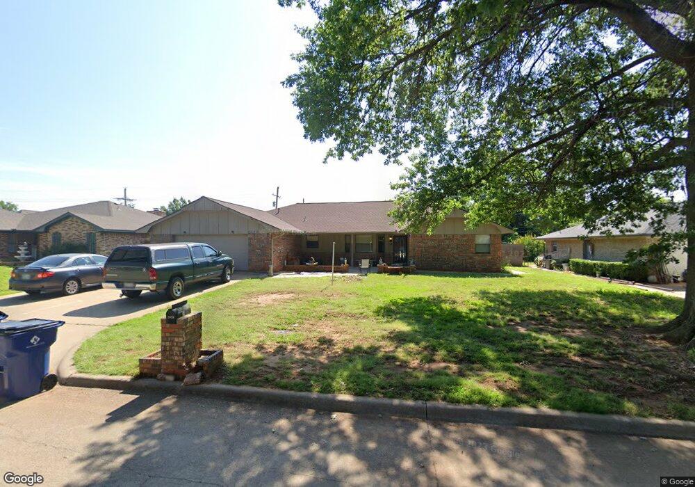
2020 Woodrock Dr Duncan, OK 73533
Estimated Value: $215,000 - $240,000
3
Beds
2
Baths
2,332
Sq Ft
$98/Sq Ft
Est. Value
About This Home
This home is located at 2020 Woodrock Dr, Duncan, OK 73533 and is currently estimated at $228,819, approximately $98 per square foot. 2020 Woodrock Dr is a home located in Stephens County with nearby schools including Horace Mann Elementary School, Duncan Middle School, and Duncan High School.
Ownership History
Date
Name
Owned For
Owner Type
Purchase Details
Closed on
Nov 19, 2015
Sold by
Long Jill T and Clift Patti J
Bought by
Weis Gerard C and Weis Shawna C
Current Estimated Value
Home Financials for this Owner
Home Financials are based on the most recent Mortgage that was taken out on this home.
Original Mortgage
$139,900
Outstanding Balance
$109,960
Interest Rate
3.85%
Mortgage Type
VA
Estimated Equity
$118,859
Purchase Details
Closed on
Nov 18, 2014
Sold by
Ward Mary Helen
Bought by
Ward Mary H and Mary H Ward Revocable Trust
Purchase Details
Closed on
May 18, 2011
Sold by
Lowe Richard Dwight and Lowe Patricia E
Bought by
Ward Mary Helen
Purchase Details
Closed on
Aug 25, 1996
Sold by
Brennan William E and Brennan Iii
Create a Home Valuation Report for This Property
The Home Valuation Report is an in-depth analysis detailing your home's value as well as a comparison with similar homes in the area
Home Values in the Area
Average Home Value in this Area
Purchase History
| Date | Buyer | Sale Price | Title Company |
|---|---|---|---|
| Weis Gerard C | $140,000 | None Available | |
| Ward Mary H | -- | None Available | |
| Ward Mary Helen | -- | None Available | |
| -- | $95,500 | -- |
Source: Public Records
Mortgage History
| Date | Status | Borrower | Loan Amount |
|---|---|---|---|
| Open | Weis Gerard C | $139,900 |
Source: Public Records
Tax History Compared to Growth
Tax History
| Year | Tax Paid | Tax Assessment Tax Assessment Total Assessment is a certain percentage of the fair market value that is determined by local assessors to be the total taxable value of land and additions on the property. | Land | Improvement |
|---|---|---|---|---|
| 2025 | $1,327 | $17,071 | $1,360 | $15,711 |
| 2024 | $1,327 | $16,573 | $1,360 | $15,213 |
| 2023 | $1,327 | $16,574 | $1,360 | $15,214 |
| 2022 | $1,243 | $16,091 | $1,360 | $14,731 |
| 2021 | $1,206 | $15,167 | $1,360 | $13,807 |
| 2020 | $1,237 | $15,321 | $1,360 | $13,961 |
| 2019 | $1,287 | $14,875 | $1,360 | $13,515 |
| 2018 | $1,410 | $16,038 | $1,360 | $14,678 |
| 2017 | $1,296 | $15,083 | $1,360 | $13,723 |
| 2016 | $1,397 | $16,434 | $1,360 | $15,074 |
| 2015 | $1,358 | $16,536 | $1,360 | $15,176 |
| 2014 | $1,358 | $16,289 | $1,271 | $15,018 |
Source: Public Records
Map
Nearby Homes
- 2018 Woodrock Dr
- 1927 High Meadow Dr
- 1706 Windsor Dr
- 1829 1829 Terrace Dr
- 2403 Meadow View Dr
- 2360 Rockwell Dr
- 2321 Rockwell Dr
- 3990 N Ridgeview Dr
- 2129 W Mallard Dr
- 2201 W Club Rd
- 2110 W Club Rd
- 28 Canterbury Ln
- 30 Canterbury Ln
- 1601 1601 Pearl
- 2120 2120 Flamingo Ln
- 1404 1404 Ne Aspen
- 2814 2814 Springdale Ln
- 1527 1527 N 13th
- 2202 W Canary Ave
- 1405 Evergreen Dr
- 2024 2024 N Woodrock Dr
- 2018 2018 N Woodrock Dr
- 2024 Woodrock Dr
- 1818 Parkwood Dr
- 2014 Woodrock Dr
- 2014 2014 Woodrock Dr
- 2021 2021 Woodrock Dr
- 2021 Woodrock Dr
- 2025 Woodrock Dr
- 1814 Parkwood Dr
- 2017 Woodrock Dr
- 2104 Woodrock Dr
- 2101 Woodrock Dr
- 2013 Woodrock Dr
- 2013 2013 Woodrock
- 2010 Woodrock Dr
- 1810 Parkwood Dr
- 2105 Woodrock Dr
- 2105 2105 Woodrock Dr
- 1817 Parkwood Dr