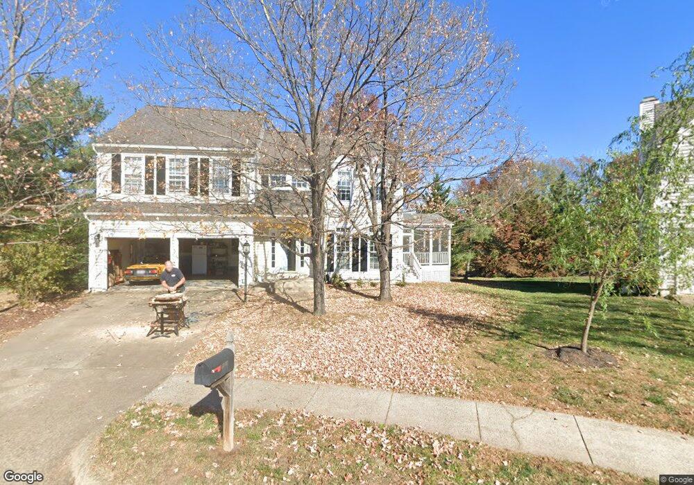
20206 Birdsnest Place Ashburn, VA 20147
Estimated Value: $914,742 - $935,000
4
Beds
4
Baths
2,422
Sq Ft
$382/Sq Ft
Est. Value
About This Home
This home is located at 20206 Birdsnest Place, Ashburn, VA 20147 and is currently estimated at $924,936, approximately $381 per square foot. 20206 Birdsnest Place is a home located in Loudoun County with nearby schools including Ashburn Elementary School, Farmwell Station Middle School, and Broad Run High School.
Ownership History
Date
Name
Owned For
Owner Type
Purchase Details
Closed on
Sep 23, 1996
Sold by
Powell David K
Bought by
Hellstrom Daniel M
Current Estimated Value
Home Financials for this Owner
Home Financials are based on the most recent Mortgage that was taken out on this home.
Original Mortgage
$174,400
Outstanding Balance
$14,566
Interest Rate
7.89%
Estimated Equity
$910,370
Create a Home Valuation Report for This Property
The Home Valuation Report is an in-depth analysis detailing your home's value as well as a comparison with similar homes in the area
Home Values in the Area
Average Home Value in this Area
Purchase History
| Date | Buyer | Sale Price | Title Company |
|---|---|---|---|
| Hellstrom Daniel M | $218,000 | -- |
Source: Public Records
Mortgage History
| Date | Status | Borrower | Loan Amount |
|---|---|---|---|
| Open | Hellstrom Daniel M | $174,400 |
Source: Public Records
Tax History Compared to Growth
Tax History
| Year | Tax Paid | Tax Assessment Tax Assessment Total Assessment is a certain percentage of the fair market value that is determined by local assessors to be the total taxable value of land and additions on the property. | Land | Improvement |
|---|---|---|---|---|
| 2025 | $6,771 | $841,110 | $299,000 | $542,110 |
| 2024 | $6,820 | $788,440 | $294,000 | $494,440 |
| 2023 | $6,800 | $777,170 | $294,000 | $483,170 |
| 2022 | $6,569 | $738,060 | $269,000 | $469,060 |
| 2021 | $6,315 | $644,400 | $219,000 | $425,400 |
| 2020 | $6,251 | $603,920 | $197,000 | $406,920 |
| 2019 | $6,195 | $592,790 | $197,000 | $395,790 |
| 2018 | $5,860 | $540,080 | $177,000 | $363,080 |
| 2017 | $5,933 | $527,410 | $177,000 | $350,410 |
| 2016 | $6,087 | $531,630 | $0 | $0 |
| 2015 | $5,714 | $326,450 | $0 | $326,450 |
| 2014 | $5,636 | $310,930 | $0 | $310,930 |
Source: Public Records
Map
Nearby Homes
- 43878 Camellia St
- 44049 Ferncliff Terrace
- 20044 Crew Square
- 44005 Gala Cir
- 44094 Gala Cir
- 20278 Glenrobin Terrace
- 20314 Snowpoint Place
- 20331 Susan Leslie Dr
- 20129 Valhalla Square
- 43820 Laurel Ridge Dr
- 44217 Navajo Dr
- 20153 Valhalla Square
- 20231 Hidden Creek Ct
- 19917 Interlachen Cir
- 44004 Florence Terrace
- 43582 Old Kinderhook Dr
- 44180 Shady Glen Terrace
- 20402 Cool Fern Square
- 20576 Ashburn Rd
- 44049 Florence Terrace
- 20210 Birdsnest Place
- 20214 Birdsnest Place
- 20203 Birdsnest Place
- 44076 Ferncliff Terrace
- 44074 Ferncliff Terrace
- 44072 Ferncliff Terrace
- 44070 Ferncliff Terrace
- 44068 Ferncliff Terrace
- 20207 Birdsnest Place
- 44078 Ferncliff Terrace
- 20218 Birdsnest Place
- 44064 Ferncliff Terrace
- 20211 Birdsnest Place
- 44080 Ferncliff Terrace
- 20215 Birdsnest Place
- 44062 Ferncliff Terrace
- 44082 Ferncliff Terrace
- 20175 Black Horse Square
- 44084 Ferncliff Terrace
- 20179 Black Horse Square