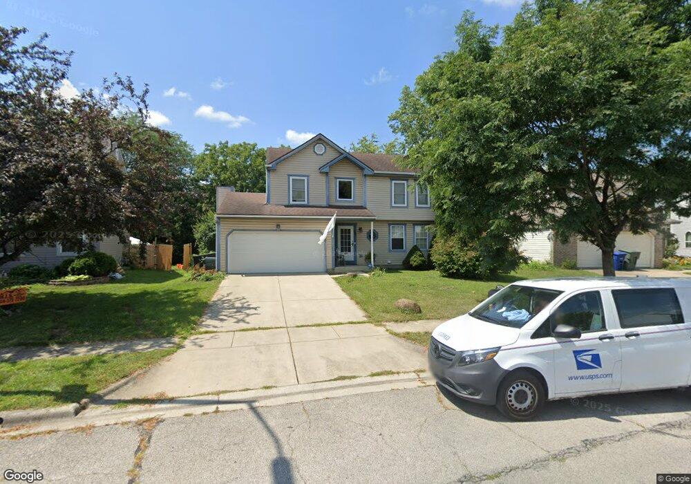
2021 Big Tree Dr Columbus, OH 43223
Estimated Value: $274,000 - $340,000
3
Beds
3
Baths
1,908
Sq Ft
$159/Sq Ft
Est. Value
About This Home
This home is located at 2021 Big Tree Dr, Columbus, OH 43223 and is currently estimated at $303,775, approximately $159 per square foot. 2021 Big Tree Dr is a home located in Franklin County with nearby schools including Finland Elementary School, Franklin Woods Intermediate School, and Finland Middle School.
Ownership History
Date
Name
Owned For
Owner Type
Purchase Details
Closed on
Feb 27, 2025
Sold by
Angels Venture Trust and Shelton David W
Bought by
Gilespie Martha Ann
Current Estimated Value
Purchase Details
Closed on
Aug 17, 2015
Sold by
Shelton David W and Shelton Angela
Bought by
Shelton David W and Shelton Angela
Purchase Details
Closed on
May 14, 1999
Sold by
Bridger Frederick O and Bridger Sharon L
Bought by
Shelton David W and Shelton Angela
Purchase Details
Closed on
Dec 8, 1994
Sold by
Maronda Homes Inc
Bought by
Bridger Frederick O and Bridger Sharon L
Home Financials for this Owner
Home Financials are based on the most recent Mortgage that was taken out on this home.
Original Mortgage
$102,600
Interest Rate
5.25%
Mortgage Type
New Conventional
Purchase Details
Closed on
Feb 11, 1994
Create a Home Valuation Report for This Property
The Home Valuation Report is an in-depth analysis detailing your home's value as well as a comparison with similar homes in the area
Home Values in the Area
Average Home Value in this Area
Purchase History
| Date | Buyer | Sale Price | Title Company |
|---|---|---|---|
| Gilespie Martha Ann | $256,300 | None Listed On Document | |
| Shelton David W | -- | Attorney | |
| Shelton David W | $115,000 | -- | |
| Bridger Frederick O | $108,050 | -- | |
| -- | $175,000 | -- |
Source: Public Records
Mortgage History
| Date | Status | Borrower | Loan Amount |
|---|---|---|---|
| Previous Owner | Bridger Frederick O | $102,600 |
Source: Public Records
Tax History Compared to Growth
Tax History
| Year | Tax Paid | Tax Assessment Tax Assessment Total Assessment is a certain percentage of the fair market value that is determined by local assessors to be the total taxable value of land and additions on the property. | Land | Improvement |
|---|---|---|---|---|
| 2024 | $3,355 | $89,710 | $21,390 | $68,320 |
| 2023 | $3,447 | $89,705 | $21,385 | $68,320 |
| 2022 | $3,223 | $64,370 | $18,830 | $45,540 |
| 2021 | $3,288 | $64,370 | $18,830 | $45,540 |
| 2020 | $3,271 | $64,370 | $18,830 | $45,540 |
| 2019 | $2,875 | $49,910 | $15,050 | $34,860 |
| 2018 | $2,674 | $49,910 | $15,050 | $34,860 |
| 2017 | $2,853 | $49,910 | $15,050 | $34,860 |
| 2016 | $2,486 | $39,940 | $5,880 | $34,060 |
| 2015 | $2,485 | $39,940 | $5,880 | $34,060 |
| 2014 | $2,419 | $39,940 | $5,880 | $34,060 |
| 2013 | $1,263 | $42,035 | $6,195 | $35,840 |
Source: Public Records
Map
Nearby Homes
- 1543 Red Leaf Ln
- 2210 October Ridge Dr
- 1607 Red Leaf Ln
- 1417 Fahy Dr
- 1390 Gray Meadow Dr
- 1723 Farberdale Dr
- 0 S Central Ave
- 1994 Little Ave
- 2180 Eakin Rd
- 2336 Woodbrook Cir N Unit 92 B
- 1122 Harrisburg Pike
- 2362 Woodbrook Cir N Unit 81
- 1532 Westmeadow Dr
- 1948 Big Run Bluffs Blvd
- 1949 Big Run Bluffs Blvd
- 1119 Hardesty Place E Unit 1
- 1085 Hardesty Place E Unit 4
- 1663 Hopkins Ave
- 2382 Hardesty Dr S Unit Q-5
- 1757 Linnet Ave
- 2015 Big Tree Dr
- 2027 Big Tree Dr
- 2033 Big Tree Dr
- 2009 Big Tree Dr
- 2016 Big Tree Dr
- 2039 Big Tree Dr
- 1999 Little Water Dr
- 2008 Big Tree Dr
- 2042 Big Tree Dr
- 2045 Big Tree Dr
- 1458 Ellicot Ct
- 2000 Big Tree Dr
- 1459 Ellicot Ct
- 1993 Little Water Dr
- 2051 Big Tree Dr
- 1998 Little Water Dr
- 2050 Big Tree Dr
- 1992 Big Tree Dr
- 1990 Little Water Dr
- 2130 Summer Breeze Dr