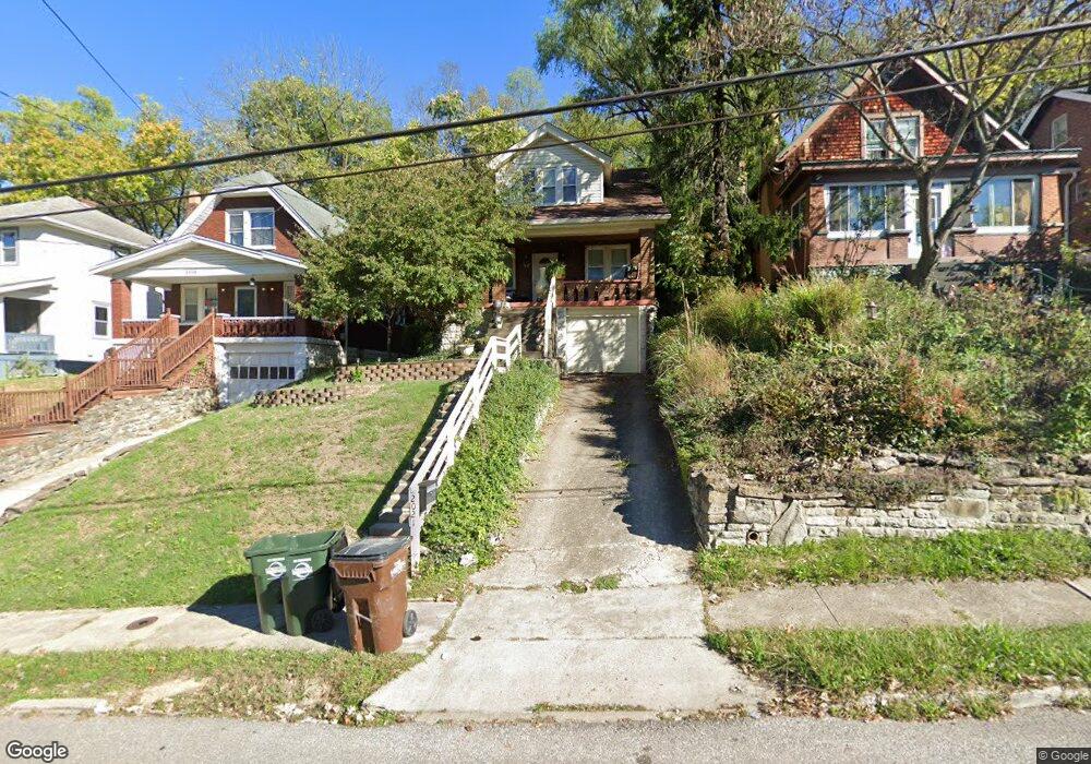
2021 New Linden Rd Newport, KY 41071
Estimated Value: $186,000 - $208,000
2
Beds
1
Bath
1,048
Sq Ft
$188/Sq Ft
Est. Value
About This Home
This home is located at 2021 New Linden Rd, Newport, KY 41071 and is currently estimated at $197,409, approximately $188 per square foot. 2021 New Linden Rd is a home located in Campbell County with nearby schools including Newport Primary School, Newport Intermediate School, and Newport High School.
Ownership History
Date
Name
Owned For
Owner Type
Purchase Details
Closed on
Nov 14, 2003
Sold by
Strange Jeffery W and Strange Margaret A
Bought by
Mathis Richard
Current Estimated Value
Home Financials for this Owner
Home Financials are based on the most recent Mortgage that was taken out on this home.
Original Mortgage
$72,000
Interest Rate
5.62%
Mortgage Type
Purchase Money Mortgage
Purchase Details
Closed on
Feb 4, 2002
Sold by
Burkart Joseph G
Bought by
Strange Jeffrey W and Strange Margaret A
Home Financials for this Owner
Home Financials are based on the most recent Mortgage that was taken out on this home.
Original Mortgage
$88,749
Interest Rate
7.14%
Mortgage Type
FHA
Create a Home Valuation Report for This Property
The Home Valuation Report is an in-depth analysis detailing your home's value as well as a comparison with similar homes in the area
Home Values in the Area
Average Home Value in this Area
Purchase History
| Date | Buyer | Sale Price | Title Company |
|---|---|---|---|
| Mathis Richard | $90,000 | First Title Agency Inc | |
| Strange Jeffrey W | $89,900 | -- |
Source: Public Records
Mortgage History
| Date | Status | Borrower | Loan Amount |
|---|---|---|---|
| Previous Owner | Mathis Richard | $72,000 | |
| Previous Owner | Strange Jeffrey W | $88,749 |
Source: Public Records
Tax History Compared to Growth
Tax History
| Year | Tax Paid | Tax Assessment Tax Assessment Total Assessment is a certain percentage of the fair market value that is determined by local assessors to be the total taxable value of land and additions on the property. | Land | Improvement |
|---|---|---|---|---|
| 2024 | $538 | $139,800 | $20,000 | $119,800 |
| 2023 | $369 | $93,300 | $9,800 | $83,500 |
| 2022 | $440 | $93,300 | $9,800 | $83,500 |
| 2021 | $451 | $93,300 | $9,800 | $83,500 |
| 2020 | $459 | $93,300 | $9,800 | $83,500 |
| 2019 | $449 | $90,000 | $9,800 | $80,200 |
| 2018 | $443 | $90,000 | $9,800 | $80,200 |
| 2017 | $445 | $90,000 | $9,800 | $80,200 |
| 2016 | $415 | $90,000 | $0 | $0 |
| 2015 | $422 | $90,000 | $0 | $0 |
| 2014 | $414 | $90,000 | $0 | $0 |
Source: Public Records
Map
Nearby Homes
- 2115 Monmouth St
- 2115 Joyce Ave
- 39 19th St
- 2220 New Linden Rd
- 100 Mayo Cir
- 8 Laycock Ln
- 43.5-45.5, Kentucky Dr
- 85 & 87 Kentucky Dr
- 94 Home St
- 12 Amelia St
- 58 16th St
- 260 Bluegrass Ave
- 252 Linden Ave
- 120 Main St Unit 205
- 120 Main St Unit 306
- 120 Main St Unit 313
- 120 Main St Unit 323
- 125 15th St
- 41 W 14th St
- 35 W 14th St Unit Lot 43
- 2023 New Linden Rd
- 2019 New Linden Rd
- 2025 New Linden Rd
- 2017 New Linden Rd
- 2027 New Linden Rd
- 2015 New Linden Rd
- 2029 New Linden Rd
- 2026 New Linden Rd
- 2031 New Linden Rd
- 2001 Monmouth St
- 20 W Ridge Place
- 2003 Monmouth St
- 21 W Ridge Place
- 2028 New Linden Rd
- 18 W Ridge Place
- 2033 New Linden Rd
- 2005 Monmouth St
- 2030 New Linden Rd
- 2007 Monmouth St
- 2035 New Linden Rd