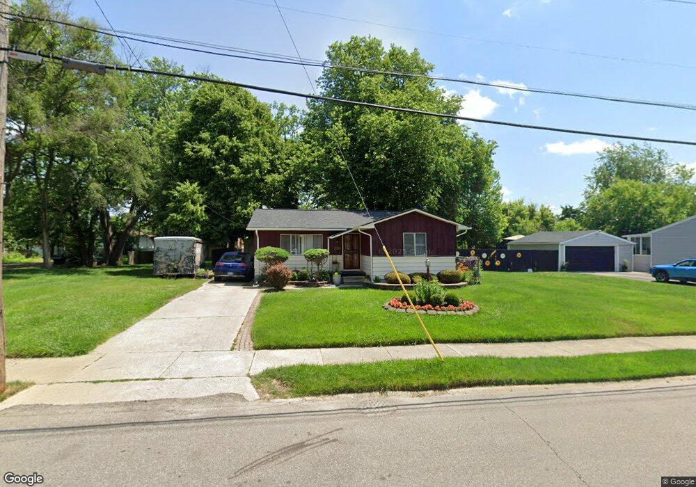
2021 Seymour Ave Flint, MI 48503
South Parks NeighborhoodEstimated Value: $74,160 - $103,000
3
Beds
1
Bath
979
Sq Ft
$96/Sq Ft
Est. Value
About This Home
This home is located at 2021 Seymour Ave, Flint, MI 48503 and is currently estimated at $94,040, approximately $96 per square foot. 2021 Seymour Ave is a home located in Genesee County with nearby schools including Freeman Elementary School, Flint Southwestern Classical Academy, and International Academy of Flint (K-12).
Ownership History
Date
Name
Owned For
Owner Type
Purchase Details
Closed on
Jul 25, 2014
Sold by
Reaves Kendall E
Bought by
Williams Williams Keith Keith and Williams Reaves Tekilla J
Current Estimated Value
Purchase Details
Closed on
Aug 9, 2002
Sold by
Mitchell Wilma J and Reaves Kendall E
Bought by
Williams Reaves Keith and Williams Reaves Tekilla J
Purchase Details
Closed on
Jun 20, 2002
Sold by
Williams Reaves Keith and Williams Reaves Tekilla J
Bought by
Mitchell Wilma J and Reaves Kendall E
Create a Home Valuation Report for This Property
The Home Valuation Report is an in-depth analysis detailing your home's value as well as a comparison with similar homes in the area
Home Values in the Area
Average Home Value in this Area
Purchase History
| Date | Buyer | Sale Price | Title Company |
|---|---|---|---|
| Williams Williams Keith Keith | -- | None Available | |
| Williams Reaves Keith | $26,521 | -- | |
| Mitchell Wilma J | -- | Titlequest Agency | |
| Mitchell Wilma J | -- | Titlequest Agency |
Source: Public Records
Mortgage History
| Date | Status | Borrower | Loan Amount |
|---|---|---|---|
| Closed | Williams Reaves Keith | $0 |
Source: Public Records
Tax History Compared to Growth
Tax History
| Year | Tax Paid | Tax Assessment Tax Assessment Total Assessment is a certain percentage of the fair market value that is determined by local assessors to be the total taxable value of land and additions on the property. | Land | Improvement |
|---|---|---|---|---|
| 2025 | $881 | $34,400 | $0 | $0 |
| 2024 | $802 | $30,200 | $0 | $0 |
| 2023 | $790 | $25,700 | $0 | $0 |
| 2022 | $0 | $23,100 | $0 | $0 |
| 2021 | $818 | $19,600 | $0 | $0 |
| 2020 | $742 | $15,600 | $0 | $0 |
| 2019 | $725 | $14,400 | $0 | $0 |
| 2018 | $717 | $13,100 | $0 | $0 |
| 2017 | $698 | $0 | $0 | $0 |
| 2016 | $694 | $0 | $0 | $0 |
| 2015 | -- | $0 | $0 | $0 |
| 2014 | -- | $0 | $0 | $0 |
| 2012 | -- | $12,300 | $0 | $0 |
Source: Public Records
Map
Nearby Homes
- 1917 Whittlesey St
- 1937 Chelan St
- 1601 Wayne St
- 9211 Owen St
- 1840 Mcphail St
- 2029 Aitken Ave
- 1110 Pingree Ave
- 2618 Pinetree Dr
- 2221 Howard Ave
- 2010 Crocker Ave
- 2224 Crocker Ave
- 2121 Dwight Ave
- 2050 Ferris Ave
- 1510 S Franklin Ave
- 2910 Shawnee Ave
- 1409 S Franklin Ave
- 420 Pingree Ave
- 1925 Gilmartin St
- 1940 Tebo St
- 3115 Circle Dr
- 2013 Seymour Ave
- 2029 Seymour Ave
- 2018 Barks St
- 2022 Barks St
- 2033 Seymour Ave
- 2009 Seymour Ave
- 2014 Barks St
- 2026 Barks St
- 2010 Barks St
- 2022 Seymour Ave
- 2026 Seymour Ave
- 2037 Seymour Ave
- 2018 Seymour Ave
- 2030 Barks St
- 2030 Seymour Ave
- 2014 Seymour Ave
- 2034 Seymour Ave
- 2010 Seymour Ave
- 2006 Barks St
- 2001 Seymour Ave