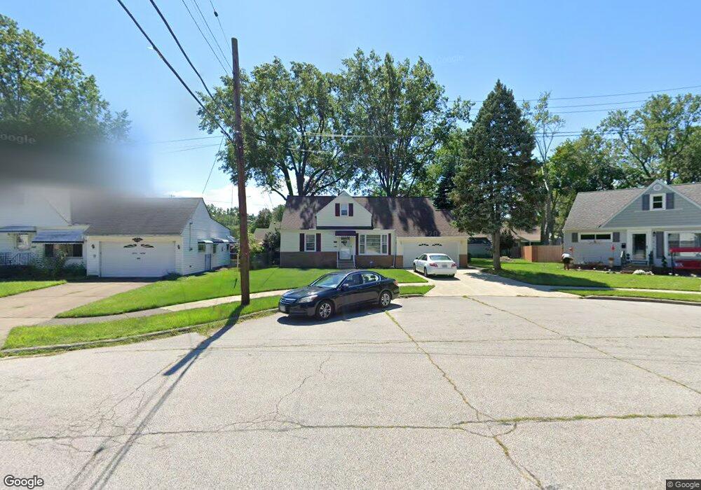
20210 Kathy Dr Euclid, OH 44117
Estimated Value: $164,000 - $228,000
4
Beds
2
Baths
2,032
Sq Ft
$99/Sq Ft
Est. Value
About This Home
This home is located at 20210 Kathy Dr, Euclid, OH 44117 and is currently estimated at $200,324, approximately $98 per square foot. 20210 Kathy Dr is a home located in Cuyahoga County with nearby schools including Bluestone Elementary School, Euclid Middle School, and Euclid High School.
Ownership History
Date
Name
Owned For
Owner Type
Purchase Details
Closed on
Jun 6, 2023
Sold by
Moore Kenneth E and Moore Regina C
Bought by
Robertson Tangela R
Current Estimated Value
Purchase Details
Closed on
Aug 30, 1996
Sold by
Green Anthony C
Bought by
Moore Kenneth E and Moore Regina C
Home Financials for this Owner
Home Financials are based on the most recent Mortgage that was taken out on this home.
Original Mortgage
$94,500
Interest Rate
8.3%
Mortgage Type
New Conventional
Purchase Details
Closed on
Oct 12, 1989
Bought by
Green Anthony Curtis Aka
Purchase Details
Closed on
May 23, 1989
Sold by
Strothers William
Bought by
The Sec. Of H.U.D.
Purchase Details
Closed on
Sep 9, 1987
Sold by
Yaggie Richard J and Yaggie Betty L
Bought by
Strothers William
Purchase Details
Closed on
Jan 1, 1975
Bought by
Yaggie Richard J and Yaggie Betty L
Create a Home Valuation Report for This Property
The Home Valuation Report is an in-depth analysis detailing your home's value as well as a comparison with similar homes in the area
Home Values in the Area
Average Home Value in this Area
Purchase History
| Date | Buyer | Sale Price | Title Company |
|---|---|---|---|
| Robertson Tangela R | -- | -- | |
| Moore Kenneth E | $99,500 | -- | |
| Green Anthony Curtis Aka | $69,600 | -- | |
| The Sec. Of H.U.D. | -- | -- | |
| Strothers William | $72,000 | -- | |
| Yaggie Richard J | -- | -- |
Source: Public Records
Mortgage History
| Date | Status | Borrower | Loan Amount |
|---|---|---|---|
| Previous Owner | Moore Kenneth E | $94,500 |
Source: Public Records
Tax History Compared to Growth
Tax History
| Year | Tax Paid | Tax Assessment Tax Assessment Total Assessment is a certain percentage of the fair market value that is determined by local assessors to be the total taxable value of land and additions on the property. | Land | Improvement |
|---|---|---|---|---|
| 2024 | $3,945 | $57,785 | $10,220 | $47,565 |
| 2023 | $3,443 | $40,110 | $9,030 | $31,080 |
| 2022 | $3,537 | $42,250 | $9,030 | $33,220 |
| 2021 | $3,943 | $42,250 | $9,030 | $33,220 |
| 2020 | $3,735 | $36,400 | $7,770 | $28,630 |
| 2019 | $3,362 | $104,000 | $22,200 | $81,800 |
| 2018 | $3,394 | $36,400 | $7,770 | $28,630 |
| 2017 | $3,543 | $31,720 | $5,640 | $26,080 |
| 2016 | $3,550 | $31,720 | $5,640 | $26,080 |
| 2015 | $4,865 | $31,720 | $5,640 | $26,080 |
| 2014 | $4,865 | $31,720 | $5,640 | $26,080 |
Source: Public Records
Map
Nearby Homes
- 19871 Upper Valley Dr
- 2150 Glenridge Rd
- 19201 Shawnee Rd
- 1721 Grand Blvd
- 19201 Genesee Rd
- 1860 Glenridge Rd
- 24 Washington Square
- 209 Greenbriar Ct
- 1777 Catalpa Rd
- 1477 E 195th St
- 237 Greenbriar Ct Unit F237
- 2441 Malden Rd
- 2337 Greenvale Rd
- 1524 E 204th St
- 1707 Catalpa Rd
- 1563 Clermont Rd
- 2536 Greenvale Rd
- 2010 E 221st St
- 18120 Olympia Rd
- 1769 Burgess Rd
- 20220 Kathy Dr
- 1810 Pinehurst Dr
- 20211 Delaware Dr
- 20221 Delaware Dr
- 20230 Kathy Dr
- 1808 Pinehurst Dr
- 20201 Delaware Dr
- 20231 Delaware Dr
- 1807 Pinehurst Dr
- 1891 Sagamore Dr
- 20240 Kathy Dr
- 1806 Pinehurst Dr
- 20241 Delaware Dr
- 1865 Sagamore Dr
- 1901 Sagamore Dr
- 1805 Pinehurst Dr
- 1806 Karen Dr
- 1804 Pinehurst Dr
- 20250 Kathy Dr
- 20251 Delaware Dr