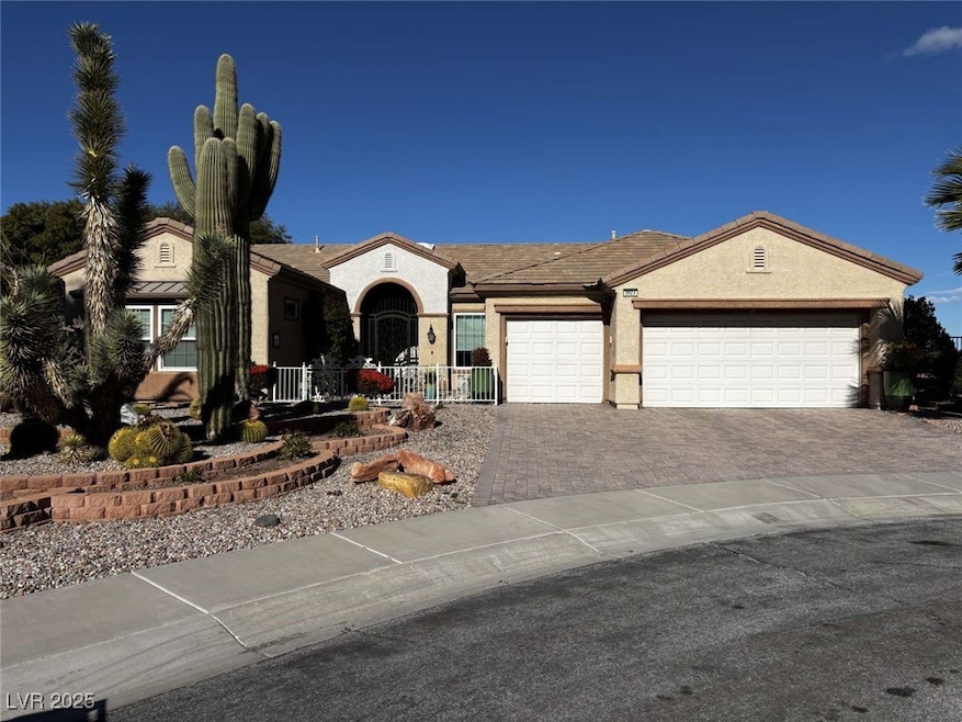


2023 May Valley Way Unit 15 Henderson, NV 89052
Sun City Anthem NeighborhoodEstimated payment $6,366/month
Highlights
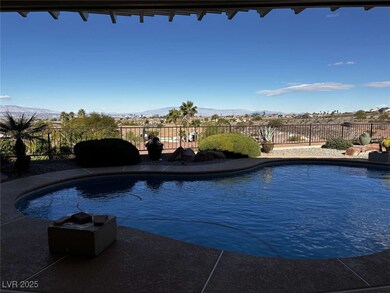
- In Ground Pool
- Deck
- Skylights
- Active Adult
- Covered Patio or Porch
- 3 Car Attached Garage
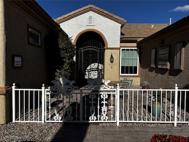
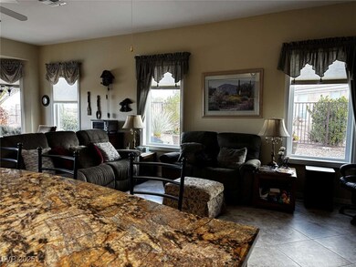
About This Home
Welcome to this charming single-story home, set on a spacious 0.28-acre lot within a highly desirable 55 + community. Enjoy energy-efficient living with a solar-powered pool water heater and an open, light-filled floor plan. The generously sized primary suite offers comfort and privacy, while the backyard oasis features desert landscaping and sweeping views of the Las Vegas skyline. Move-in ready and beautifully maintained, this home blends style and comfort with access to resort-style amenities perfect for an active lifestyle.
Listing Agent
Congress Realty Brokerage Phone: 888-881-4118 License #B.1001537 Listed on: 12/01/2025
Home Details
Home Type
- Single Family
Est. Annual Taxes
- $5,480
Year Built
- Built in 2002
Lot Details
- 0.28 Acre Lot
- East Facing Home
- Wrought Iron Fence
- Back Yard Fenced
- Desert Landscape
HOA Fees
- $145 Monthly HOA Fees
Parking
- 3 Car Attached Garage
Home Design
- Tile Roof
Interior Spaces
- 2,446 Sq Ft Home
- 1-Story Property
- Partially Furnished
- Ceiling Fan
- Skylights
- Double Pane Windows
- Awning
- Insulated Windows
- Blinds
- Drapes & Rods
Kitchen
- Convection Oven
- Microwave
- ENERGY STAR Qualified Appliances
- Disposal
Flooring
- Carpet
- Laminate
- Ceramic Tile
Bedrooms and Bathrooms
- 2 Bedrooms
Laundry
- Laundry Room
- Laundry on main level
- Dryer
- Washer
Eco-Friendly Details
- Energy-Efficient Windows
- Energy-Efficient Doors
Outdoor Features
- In Ground Pool
- Courtyard
- Deck
- Covered Patio or Porch
Schools
- Wolff Elementary School
- Webb Middle School
- Coronado High School
Utilities
- Central Heating and Cooling System
- Heating System Uses Gas
- Underground Utilities
- Water Purifier
- Cable TV Available
Community Details
- Active Adult
- Association fees include management
- Sun City Anthem Association, Phone Number (702) 614-5800
- Sun City Anthem Subdivision
Map
Home Values in the Area
Average Home Value in this Area
Tax History
| Year | Tax Paid | Tax Assessment Tax Assessment Total Assessment is a certain percentage of the fair market value that is determined by local assessors to be the total taxable value of land and additions on the property. | Land | Improvement |
|---|---|---|---|---|
| 2025 | $5,480 | $225,207 | $85,575 | $139,632 |
| 2024 | $5,321 | $225,207 | $85,575 | $139,632 |
| 2023 | $5,321 | $213,382 | $81,725 | $131,657 |
| 2022 | $5,166 | $193,208 | $72,870 | $120,338 |
| 2021 | $4,584 | $181,570 | $67,095 | $114,475 |
| 2020 | $4,445 | $179,895 | $66,710 | $113,185 |
| 2019 | $4,319 | $176,247 | $64,400 | $111,847 |
| 2018 | $4,196 | $170,349 | $62,475 | $107,874 |
| 2017 | $4,541 | $168,925 | $60,550 | $108,375 |
| 2016 | $3,966 | $160,174 | $51,275 | $108,899 |
| 2015 | $3,964 | $150,945 | $43,575 | $107,370 |
| 2014 | $3,846 | $143,076 | $39,725 | $103,351 |
Property History
| Date | Event | Price | List to Sale | Price per Sq Ft |
|---|---|---|---|---|
| 12/01/2025 12/01/25 | For Sale | $1,099,000 | -- | $449 / Sq Ft |
Purchase History
| Date | Type | Sale Price | Title Company |
|---|---|---|---|
| Bargain Sale Deed | $375,821 | Del Webb Title Company Nevad |
Mortgage History
| Date | Status | Loan Amount | Loan Type |
|---|---|---|---|
| Previous Owner | $125,000 | No Value Available |
Source: Las Vegas REALTORS®
MLS Number: 2738343
APN: 191-13-110-091
Disclaimer: Certain information contained herein is derived from information provided by parties other than Homes.com. All information provided is deemed reliable, but is not guaranteed to be accurate and should be independently verified.
![]() The data relating to real estate for sale on this web site comes in part from the INTERNET DATA EXCHANGE Program of the Greater Las Vegas Association of REALTORS® MLS. Real estate listings held by brokerage firms other than this site owner are marked with the IDX logo. Information is deemed reliable but not guaranteed. Copyright 2025 of the Greater Las Vegas Association of REALTORS® MLS. All rights reserved.
The data relating to real estate for sale on this web site comes in part from the INTERNET DATA EXCHANGE Program of the Greater Las Vegas Association of REALTORS® MLS. Real estate listings held by brokerage firms other than this site owner are marked with the IDX logo. Information is deemed reliable but not guaranteed. Copyright 2025 of the Greater Las Vegas Association of REALTORS® MLS. All rights reserved.
- 2874 Hartwick Pines Dr
- 2032 Wolverine Ct
- 2784 Cherrydale Falls Dr Unit 12
- 2069 Colvin Run Dr
- 2899 Brook Trout Ct
- 2095 Colvin Run Dr
- 2810 Meadow Park Ave Unit 15
- 2790 Meadow Park Ave
- 2741 Hartwick Pines Dr
- 2170 Peyten Park St
- 2026 Wildwood Lake St
- 2134 Colvin Run Dr
- 2077 Wildwood Lake St
- 1999 Oliver Springs St
- 1898 Wallingford St
- 2138 Grand Traverse St
- 3029 Brownbirds Nest Dr Unit 17
- 2106 Fort Sanders St
- 2731 Goldcreek St
- 3048 Brownbirds Nest Dr
- 2170 Peyten Park St
- 2026 Wildwood Lake St
- 1935 Valley Center Dr
- 2882 Olivia Heights Ave
- 2079 Cotton Valley St
- 1896 Hovenweep St
- 2076 Danzinger Place
- 3025 Seaford Peak Dr Unit 10
- 3141 Baranek Ave
- 2934 Maffie St
- 2626 Portsmouth Creek Ave
- 3165 Via Como
- 2585 Portsmouth Creek Ave
- 2487 Hardin Ridge Dr Unit 19A
- 2348 Fossil Canyon Dr
- 2555 Hampton Rd Unit 4202
- 2555 Hampton Rd Unit 6204
- 2555 Hampton Rd Unit 11201
- 2555 Hampton Rd Unit 4109
- 3182 Romanesque Art Ave
