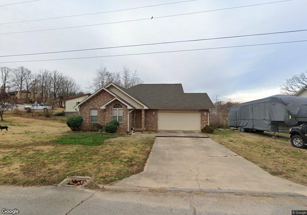
2023 Snider Rd Poplar Bluff, MO 63901
Estimated Value: $226,000 - $268,000
Studio
--
Bath
2,448
Sq Ft
$101/Sq Ft
Est. Value
About This Home
This home is located at 2023 Snider Rd, Poplar Bluff, MO 63901 and is currently estimated at $246,364, approximately $100 per square foot. 2023 Snider Rd is a home with nearby schools including O'Neal Elementary School, Poplar Bluff Fifth & Sixth Grade Center, and Poplar Bluff Junior High School.
Ownership History
Date
Name
Owned For
Owner Type
Purchase Details
Closed on
Feb 28, 2021
Sold by
Trammell John Paul and Trammell Kimberly
Bought by
Hampton Charles and Hampton Lynette
Current Estimated Value
Purchase Details
Closed on
Feb 6, 2021
Sold by
Paul Trammell and Paul Kimberly
Bought by
Hampton Charles and Hampton Lynette
Purchase Details
Closed on
Jun 23, 2006
Sold by
Pigg Rick G and Pigg Kathy S
Bought by
Trammell Jon Paul and Trammell Kimberly Mae
Home Financials for this Owner
Home Financials are based on the most recent Mortgage that was taken out on this home.
Original Mortgage
$124,000
Interest Rate
6.56%
Mortgage Type
New Conventional
Create a Home Valuation Report for This Property
The Home Valuation Report is an in-depth analysis detailing your home's value as well as a comparison with similar homes in the area
Home Values in the Area
Average Home Value in this Area
Purchase History
| Date | Buyer | Sale Price | Title Company |
|---|---|---|---|
| Hampton Charles | -- | None Available | |
| Hampton Charles | -- | None Listed On Document | |
| Hampton Charles | -- | None Listed On Document | |
| Trammell Jon Paul | -- | -- |
Source: Public Records
Mortgage History
| Date | Status | Borrower | Loan Amount |
|---|---|---|---|
| Previous Owner | Trammell Jon Paul | $124,000 |
Source: Public Records
Tax History
| Year | Tax Paid | Tax Assessment Tax Assessment Total Assessment is a certain percentage of the fair market value that is determined by local assessors to be the total taxable value of land and additions on the property. | Land | Improvement |
|---|---|---|---|---|
| 2025 | $1,741 | $36,910 | $0 | $0 |
| 2024 | $17 | $34,310 | $0 | $0 |
| 2023 | $1,657 | $34,310 | $0 | $0 |
| 2022 | $1,604 | $33,270 | $0 | $0 |
| 2021 | $1,605 | $33,270 | $0 | $0 |
| 2020 | $1,536 | $31,410 | $0 | $0 |
| 2019 | $1,535 | $31,410 | $0 | $0 |
| 2018 | $1,535 | $31,410 | $0 | $0 |
| 2017 | -- | $31,410 | $0 | $0 |
| 2016 | -- | $31,410 | $0 | $0 |
| 2015 | -- | $31,410 | $0 | $0 |
| 2014 | -- | $29,470 | $0 | $0 |
| 2012 | $1,249 | $29,330 | $0 | $0 |
Source: Public Records
Map
Nearby Homes
- 2001 Woodhaven Rd
- 1557 Haven Hills Rd
- 1301 Lurlyn Rd
- 2001 King Rd
- 2601 Forest View St
- 2105 Jackson Rd
- 1915 Old Orchard Rd
- 2305 Lee St
- 1715 Big Bend Rd
- 1723 Sunset Dr
- 2304 Lee St
- 1604 Big Bend Rd
- 2418 Channon Dr
- 1824 Seifert Dr
- 2420 Channon Dr
- 2710 Oakmoore Dr
- 1712 Seifert Dr
- 2709 Oakmoore Dr
- 2310 Earl St
- 2329 Perkins Dr
- 2129 Autumn Rd
- 2025 Snider Rd
- 2020 Snider Rd
- 2018 Snider Rd
- 2133 Autumn Rd
- 2019 Snider Rd
- 2024 Snider Rd
- 2132 Autumn Rd
- 2016 Snider Rd
- 2026 Snider Rd
- 2017 Snider Rd
- 2134 Autumn Rd
- 2015 Schweitzer Dr
- 2013 Schweitzer Dr
- 2028 Snider Rd
- 2027 Snider Rd
- 2014 Snider Rd
- 2017 Schweitzer Dr
- 2011 Schweitzer Dr
- 2015 Snider Rd
Your Personal Tour Guide
Ask me questions while you tour the home.