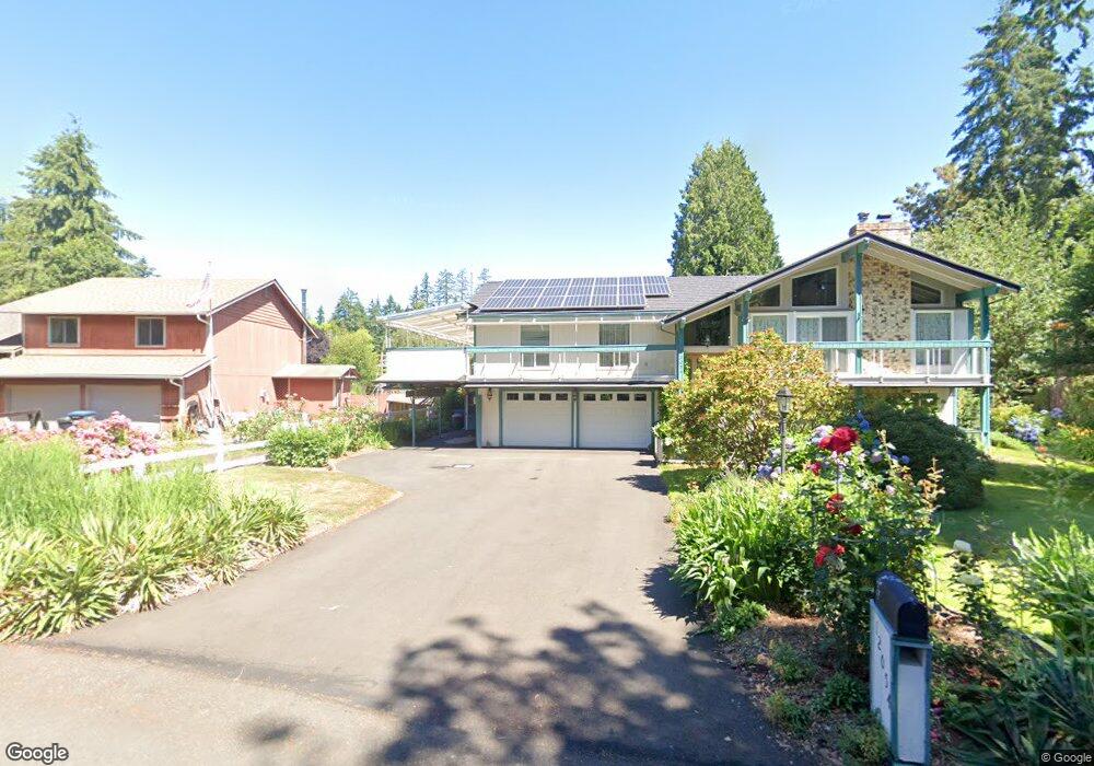
2024 NE Amhurst Ct Poulsbo, WA 98370
Estimated Value: $1,051,000 - $1,210,000
4
Beds
3
Baths
3,104
Sq Ft
$356/Sq Ft
Est. Value
About This Home
This home is located at 2024 NE Amhurst Ct, Poulsbo, WA 98370 and is currently estimated at $1,104,204, approximately $355 per square foot. 2024 NE Amhurst Ct is a home located in Kitsap County with nearby schools including Hilder Pearson Elementary School, Poulsbo Middle School, and North Kitsap High School.
Ownership History
Date
Name
Owned For
Owner Type
Purchase Details
Closed on
May 18, 1999
Sold by
Johnson Gerald E and Johnson Barbara M
Bought by
Bernstein Gordon A and Bernstein Chil S
Current Estimated Value
Home Financials for this Owner
Home Financials are based on the most recent Mortgage that was taken out on this home.
Original Mortgage
$240,000
Outstanding Balance
$61,396
Interest Rate
6.92%
Estimated Equity
$1,042,808
Create a Home Valuation Report for This Property
The Home Valuation Report is an in-depth analysis detailing your home's value as well as a comparison with similar homes in the area
Home Values in the Area
Average Home Value in this Area
Purchase History
| Date | Buyer | Sale Price | Title Company |
|---|---|---|---|
| Bernstein Gordon A | $305,000 | Transnation Title Insurance |
Source: Public Records
Mortgage History
| Date | Status | Borrower | Loan Amount |
|---|---|---|---|
| Open | Bernstein Gordon A | $240,000 |
Source: Public Records
Tax History Compared to Growth
Tax History
| Year | Tax Paid | Tax Assessment Tax Assessment Total Assessment is a certain percentage of the fair market value that is determined by local assessors to be the total taxable value of land and additions on the property. | Land | Improvement |
|---|---|---|---|---|
| 2026 | $9,835 | $1,078,340 | $213,550 | $864,790 |
| 2025 | $9,835 | $1,078,340 | $213,550 | $864,790 |
| 2024 | $9,379 | $1,067,170 | $206,930 | $860,240 |
| 2023 | $9,310 | $1,067,170 | $206,930 | $860,240 |
| 2022 | $8,313 | $855,170 | $172,440 | $682,730 |
| 2021 | $7,878 | $764,420 | $154,510 | $609,910 |
| 2020 | $7,422 | $730,210 | $147,610 | $582,600 |
| 2019 | $7,192 | $684,140 | $137,950 | $546,190 |
| 2018 | $6,713 | $536,150 | $108,560 | $427,590 |
| 2017 | $6,319 | $536,150 | $108,560 | $427,590 |
| 2016 | $6,336 | $492,380 | $108,560 | $383,820 |
| 2015 | $6,059 | $492,380 | $108,560 | $383,820 |
| 2014 | -- | $472,180 | $108,560 | $363,620 |
| 2013 | -- | $472,180 | $108,560 | $363,620 |
Source: Public Records
Map
Nearby Homes
- 2331 NE Toscana Way
- 2331 Lot C+D NE Toscana Way
- 0 S Keyport Rd NE
- 0 xxxx Brownsville Hwy NE
- 1810 NE Duck Pond Way
- 0 Brownsville Hwy NE Unit NWM2408193
- 0 NE Solar View Ct
- 13977 Blackberry Ln NE
- 2393 NE Trail Way
- 10825 Brownsville Hwy NE
- 1354 Hoffs Dr
- 1422 NW Swenson Ct
- 1533 NE Tagholm Rd
- 10211 Ogle Rd NE
- 135 Walker Rd NW
- 2051 NE Marina Vista Ct
- 1922 NE Fir St
- 9809 Shepler Rd NE
- 129 Xx Stiller Blvd NW
- 13600 Hillcrest St NW
- 2018 NE Amhurst Ct
- 2025 NE Amhurst Ct
- 0 Lot C NE Amhurst Ct
- 2012 NE Amhurst Ct
- 12060 NE Lone Tree Ct
- 12054 NE Lone Tree Ct
- 12066 NE Lone Tree Ct
- 12630 S Keyport Rd NE
- 12048 NE Lone Tree Ct
- 2007 NE Amhurst Ct
- 2006 NE Amhurst Ct
- 12072 NE Lone Tree Ct
- 0 X Lot C Ne Amhurst Ct
- 2155 NE Edwin Ct
- 12042 NE Lone Tree Ct
- 12500 S Keyport Rd NE
- 12012 NE Lone Tree Ct
- 2001 NE Amhurst Ct
- 12078 NE Lonetree Ct
- 12078 NE Lone Tree Ct