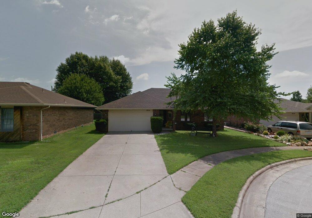
2024 S Missouri Ct Springfield, MO 65807
Mark Twain NeighborhoodEstimated Value: $233,493 - $256,000
3
Beds
2
Baths
1,500
Sq Ft
$161/Sq Ft
Est. Value
About This Home
New carpet and painting. Beautiful cut d sac. All brick home fenced yard 2024 S Missouri Ct close to bass Pro. Mercy. Shopping call Charlie to view. O/A
Ownership History
Date
Name
Owned For
Owner Type
Purchase Details
Closed on
Feb 16, 2007
Sold by
C B G Rentals Llc
Bought by
Green Charles C and Green Barbara J
Current Estimated Value
Purchase Details
Closed on
Sep 13, 2006
Sold by
Green Charles C and Green Barbara J
Bought by
C B G Rentals Llc
Purchase Details
Closed on
Aug 28, 2006
Sold by
Collector Of County Of Greene
Bought by
Green Charles C
Create a Home Valuation Report for This Property
The Home Valuation Report is an in-depth analysis detailing your home's value as well as a comparison with similar homes in the area
Home Values in the Area
Average Home Value in this Area
Purchase History
| Date | Buyer | Sale Price | Title Company |
|---|---|---|---|
| Green Charles C | -- | None Available | |
| C B G Rentals Llc | -- | None Available | |
| Green Charles C | $4,000 | None Available |
Source: Public Records
Property History
| Date | Event | Price | List to Sale | Price per Sq Ft |
|---|---|---|---|---|
| 12/13/2024 12/13/24 | Off Market | $1,495 | -- | -- |
| 11/10/2024 11/10/24 | For Rent | $1,495 | -- | -- |
Tax History Compared to Growth
Tax History
| Year | Tax Paid | Tax Assessment Tax Assessment Total Assessment is a certain percentage of the fair market value that is determined by local assessors to be the total taxable value of land and additions on the property. | Land | Improvement |
|---|---|---|---|---|
| 2025 | $1,559 | $31,290 | $5,700 | $25,590 |
| 2024 | $1,469 | $27,380 | $4,050 | $23,330 |
| 2023 | $1,461 | $27,380 | $4,050 | $23,330 |
| 2022 | $1,171 | $21,450 | $4,050 | $17,400 |
| 2021 | $1,171 | $21,450 | $4,050 | $17,400 |
| 2020 | $1,151 | $20,160 | $4,050 | $16,110 |
| 2019 | $1,119 | $20,160 | $4,050 | $16,110 |
| 2018 | $1,053 | $18,980 | $4,050 | $14,930 |
| 2017 | $1,042 | $17,880 | $4,050 | $13,830 |
| 2016 | $980 | $17,880 | $4,050 | $13,830 |
| 2015 | $971 | $17,880 | $4,050 | $13,830 |
| 2014 | $955 | $17,460 | $4,050 | $13,410 |
Source: Public Records
Map
Nearby Homes
- 853 W Whiteside St
- 1010 W Cherokee St
- 1824 S Thelma Ave
- 1858 S Franklin Ave
- 306 W McGee St
- 623 W Broadmoor St
- 1846 S Nettleton Ave
- 1909 S Nettleton Ave
- 1614 S Weaver Ave
- 2250 S Nettleton Ave
- 901 W Portland St
- 526 W Portland St
- 308 E Lindberg St
- 626 W Minota St
- 810 W Minota St
- 1135 W Portland St
- 2456 S Ferguson Ave
- 220 E Berkeley St
- 1503 W Broadmoor St
- 309 E Berkeley St
- 2018 S Missouri Ct
- 2030 S Missouri Ct
- 2012 S Missouri Ct
- 2025 S Lancaster Ave
- 2031 S Lancaster Ave
- 2034 S Missouri Ct
- 2019 S Lancaster Ave
- 2013 S Lancaster Ave
- 2006 S Missouri Ct
- 2025 S Missouri Ct
- 2019 S Missouri Ct
- 2035 S Missouri Ct
- 2035 S Lancaster Ave
- 2007 S Lancaster Ave
- 2031 S Missouri Ct
- 845 W Lois St
- 839 W Lois St
- 2011 S Missouri Ct
- 851 W Lois St
- 833 W Lois St