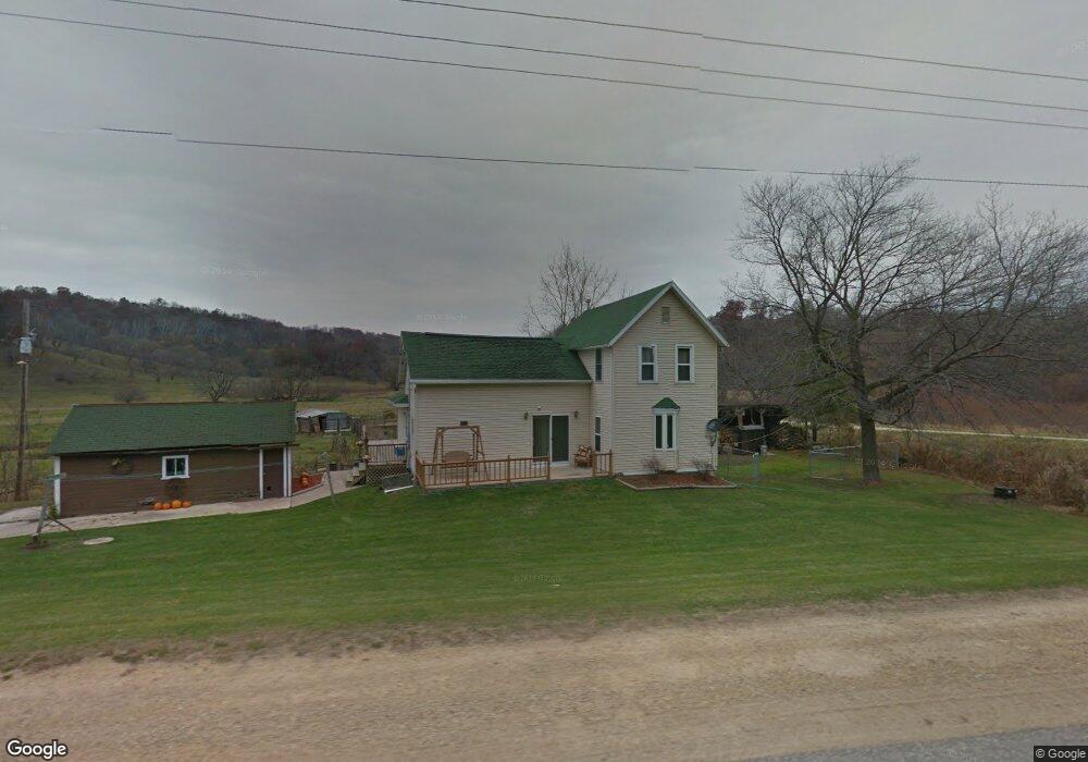
20240 State Highway 71 Norwalk, WI 54648
Estimated Value: $250,511 - $263,000
--
Bed
--
Bath
--
Sq Ft
7.15
Acres
About This Home
This home is located at 20240 State Highway 71, Norwalk, WI 54648 and is currently estimated at $255,837. 20240 State Highway 71 is a home located in Monroe County with nearby schools including Norwalk-Ontario-Wilton Elementary School and Brookwood High School.
Ownership History
Date
Name
Owned For
Owner Type
Purchase Details
Closed on
Sep 28, 2018
Sold by
Hyatt Katie L and Hyatt Ronald L
Bought by
Hanson Carrie L and Brilowski Clay C
Current Estimated Value
Home Financials for this Owner
Home Financials are based on the most recent Mortgage that was taken out on this home.
Original Mortgage
$170,900
Outstanding Balance
$149,035
Interest Rate
4.5%
Mortgage Type
New Conventional
Estimated Equity
$106,802
Create a Home Valuation Report for This Property
The Home Valuation Report is an in-depth analysis detailing your home's value as well as a comparison with similar homes in the area
Home Values in the Area
Average Home Value in this Area
Purchase History
| Date | Buyer | Sale Price | Title Company |
|---|---|---|---|
| Hanson Carrie L | -- | None Available |
Source: Public Records
Mortgage History
| Date | Status | Borrower | Loan Amount |
|---|---|---|---|
| Open | Hanson Carrie L | $170,900 |
Source: Public Records
Tax History Compared to Growth
Tax History
| Year | Tax Paid | Tax Assessment Tax Assessment Total Assessment is a certain percentage of the fair market value that is determined by local assessors to be the total taxable value of land and additions on the property. | Land | Improvement |
|---|---|---|---|---|
| 2024 | $2,422 | $125,500 | $12,400 | $113,100 |
| 2023 | $1,859 | $105,600 | $12,400 | $93,200 |
| 2022 | $1,662 | $105,600 | $12,400 | $93,200 |
| 2021 | $1,530 | $105,500 | $12,300 | $93,200 |
| 2020 | $1,394 | $77,000 | $7,800 | $69,200 |
| 2019 | $1,370 | $77,000 | $7,800 | $69,200 |
| 2018 | $1,485 | $77,000 | $7,800 | $69,200 |
| 2017 | $1,541 | $77,000 | $7,800 | $69,200 |
| 2016 | $1,457 | $77,000 | $7,800 | $69,200 |
| 2015 | $1,852 | $77,000 | $7,800 | $69,200 |
| 2014 | $1,476 | $77,000 | $7,800 | $69,200 |
| 2011 | $1,451 | $77,000 | $7,800 | $69,200 |
Source: Public Records
Map
Nearby Homes
- 205 S Water St
- 108 E South St
- 112 S Water St
- 106 N Church St
- 400 W Center St
- TBD Mead Ave
- 17326 Wisconsin 71
- 107 N West St
- 21422 Mead Ave
- 22855 Kettle Rd
- 17499 Kendall Ave
- 1101 Walker St
- 910 Water St
- 605 East St
- 21640 Nordale Ave
- TBD Kayak Rd
- 17595 Interior Rd
- 29589 Orchard Rd
- 19117 State Highway 131
- Lot 10 Hemmingford Ave