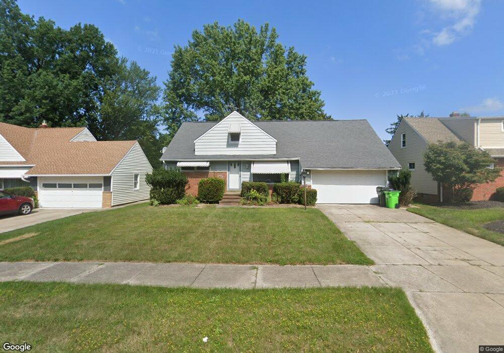
20241 Linda Dr Euclid, OH 44117
Estimated Value: $141,000 - $174,498
3
Beds
1
Bath
1,432
Sq Ft
$111/Sq Ft
Est. Value
About This Home
This home is located at 20241 Linda Dr, Euclid, OH 44117 and is currently estimated at $158,375, approximately $110 per square foot. 20241 Linda Dr is a home located in Cuyahoga County with nearby schools including Bluestone Elementary School, Euclid Middle School, and Euclid High School.
Ownership History
Date
Name
Owned For
Owner Type
Purchase Details
Closed on
Nov 30, 2007
Sold by
Cit Group/Consumer Finance Inc
Bought by
Mccraw Christopher E
Current Estimated Value
Home Financials for this Owner
Home Financials are based on the most recent Mortgage that was taken out on this home.
Original Mortgage
$99,800
Outstanding Balance
$68,841
Interest Rate
8.12%
Mortgage Type
Purchase Money Mortgage
Estimated Equity
$89,534
Purchase Details
Closed on
Dec 20, 2006
Sold by
Chatmon Ernest S and Chatmon Dolores
Bought by
The Cit Group/Consumer Finance Inc
Purchase Details
Closed on
Dec 23, 1988
Sold by
Harting Ralph J and Harting Rose A
Bought by
Chatmon Dolores
Purchase Details
Closed on
Nov 5, 1975
Sold by
Harting Ralph J and Harting Rose A
Bought by
Harting Ralph J and Harting Rose A
Purchase Details
Closed on
Jan 1, 1975
Bought by
Harting Ralph J and Harting Rose A
Create a Home Valuation Report for This Property
The Home Valuation Report is an in-depth analysis detailing your home's value as well as a comparison with similar homes in the area
Home Values in the Area
Average Home Value in this Area
Purchase History
| Date | Buyer | Sale Price | Title Company |
|---|---|---|---|
| Mccraw Christopher E | $73,000 | Revere Title | |
| The Cit Group/Consumer Finance Inc | $80,000 | Attorney | |
| Chatmon Dolores | $69,000 | -- | |
| Harting Ralph J | -- | -- | |
| Harting Ralph J | -- | -- |
Source: Public Records
Mortgage History
| Date | Status | Borrower | Loan Amount |
|---|---|---|---|
| Open | Mccraw Christopher E | $99,800 |
Source: Public Records
Tax History Compared to Growth
Tax History
| Year | Tax Paid | Tax Assessment Tax Assessment Total Assessment is a certain percentage of the fair market value that is determined by local assessors to be the total taxable value of land and additions on the property. | Land | Improvement |
|---|---|---|---|---|
| 2024 | $3,209 | $46,515 | $9,205 | $37,310 |
| 2023 | $3,224 | $37,460 | $8,090 | $29,370 |
| 2022 | $3,151 | $37,450 | $8,090 | $29,370 |
| 2021 | $3,512 | $37,450 | $8,090 | $29,370 |
| 2020 | $3,328 | $32,270 | $6,970 | $25,310 |
| 2019 | $2,993 | $92,200 | $19,900 | $72,300 |
| 2018 | $2,983 | $32,270 | $6,970 | $25,310 |
| 2017 | $3,193 | $28,490 | $5,040 | $23,450 |
| 2016 | $3,200 | $28,490 | $5,040 | $23,450 |
| 2015 | $2,911 | $28,490 | $5,040 | $23,450 |
| 2014 | $2,911 | $28,490 | $5,040 | $23,450 |
Source: Public Records
Map
Nearby Homes
- 2150 Glenridge Rd
- 19871 Upper Valley Dr
- 19201 Shawnee Rd
- 24 Washington Square
- 19201 Genesee Rd
- 2441 Malden Rd
- 209 Greenbriar Ct
- 237 Greenbriar Ct Unit F237
- 1721 Grand Blvd
- 2337 Greenvale Rd
- 1860 Glenridge Rd
- 2536 Greenvale Rd
- 1777 Catalpa Rd
- 2217 Belvoir Blvd
- 1477 E 195th St
- 4002 Lancaster Rd
- 3803 Bridgeview Dr
- 1707 Catalpa Rd
- 4031 Suffolk Rd
- 220 Greenvale Rd
- 20251 Linda Dr
- 20231 Linda Dr
- 20261 Linda Dr
- 20240 Major Dr
- 20221 Linda Dr
- 20250 Major Dr
- 20230 Major Dr
- 20260 Major Dr
- 20240 Linda Dr
- 20220 Major Dr
- 20271 Linda Dr
- 20230 Linda Dr
- 20250 Linda Dr
- 20220 Linda Dr
- 20260 Linda Dr
- 20270 Major Dr
- 2184 Crescent Dr
- 20281 Linda Dr
- 20270 Linda Dr
- 20210 Linda Dr