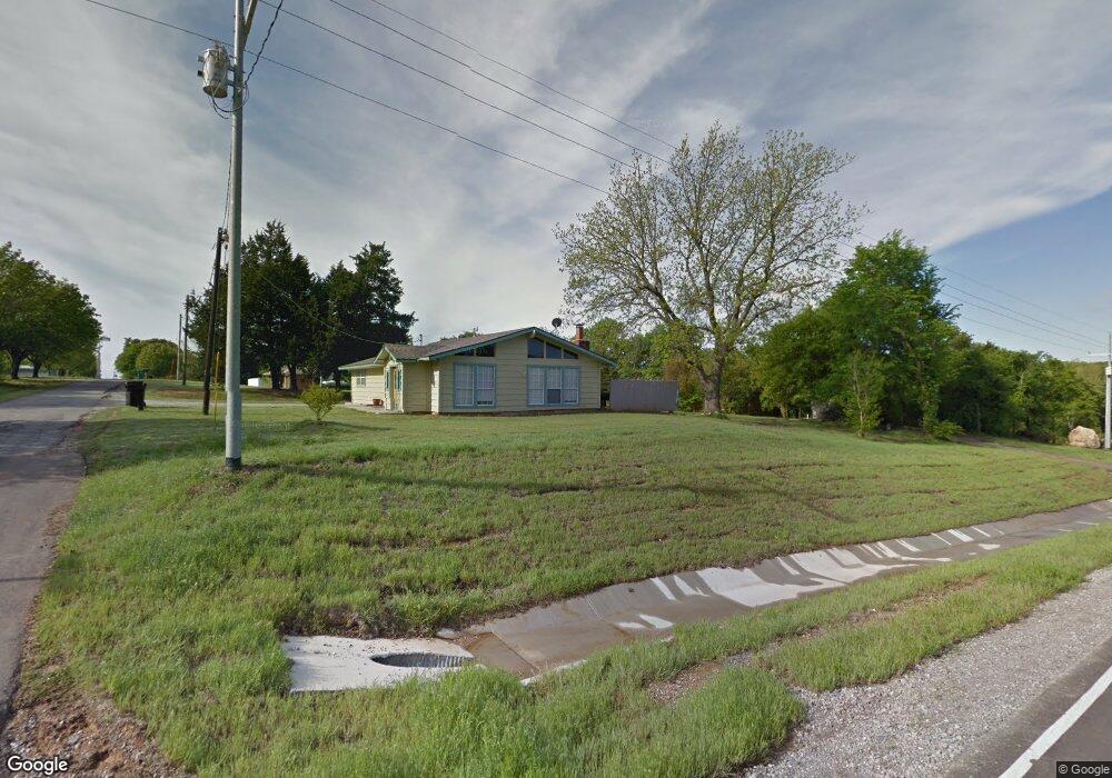
2025 Chilcoat Ln Sulphur, OK 73086
Estimated Value: $76,000 - $246,000
3
Beds
2
Baths
1,320
Sq Ft
$138/Sq Ft
Est. Value
About This Home
This home is located at 2025 Chilcoat Ln, Sulphur, OK 73086 and is currently estimated at $182,667, approximately $138 per square foot. 2025 Chilcoat Ln is a home located in Murray County with nearby schools including Sulphur Elementary School, Sulphur Intermediate School, and Sulphur Middle School.
Ownership History
Date
Name
Owned For
Owner Type
Purchase Details
Closed on
Aug 12, 2022
Sold by
Wayne Mansell
Bought by
Mansell Wayne and Mansell Manette
Current Estimated Value
Purchase Details
Closed on
May 11, 2021
Sold by
Haley Donald Dean and Haley Donald Dean
Bought by
Mansell Wayne and Mansell Manette
Home Financials for this Owner
Home Financials are based on the most recent Mortgage that was taken out on this home.
Original Mortgage
$63,000
Interest Rate
3.1%
Mortgage Type
Commercial
Purchase Details
Closed on
Sep 13, 2004
Sold by
Haley Don and Haley Carolyn
Bought by
Haley Laura
Create a Home Valuation Report for This Property
The Home Valuation Report is an in-depth analysis detailing your home's value as well as a comparison with similar homes in the area
Home Values in the Area
Average Home Value in this Area
Purchase History
| Date | Buyer | Sale Price | Title Company |
|---|---|---|---|
| Mansell Wayne | -- | None Listed On Document | |
| Mansell Wayne | $63,500 | None Available | |
| Haley Laura | $46,000 | -- |
Source: Public Records
Mortgage History
| Date | Status | Borrower | Loan Amount |
|---|---|---|---|
| Previous Owner | Mansell Wayne | $63,000 |
Source: Public Records
Tax History Compared to Growth
Tax History
| Year | Tax Paid | Tax Assessment Tax Assessment Total Assessment is a certain percentage of the fair market value that is determined by local assessors to be the total taxable value of land and additions on the property. | Land | Improvement |
|---|---|---|---|---|
| 2023 | $934 | $9,252 | $1,100 | $8,152 |
| 2022 | $794 | $8,811 | $1,100 | $7,711 |
| 2021 | $518 | $5,947 | $709 | $5,238 |
| 2020 | $493 | $5,663 | $670 | $4,993 |
| 2019 | $480 | $5,393 | $633 | $4,760 |
| 2018 | $463 | $5,137 | $550 | $4,587 |
| 2017 | $444 | $4,892 | $550 | $4,342 |
| 2016 | $457 | $4,905 | $255 | $4,650 |
| 2015 | $424 | $4,905 | $255 | $4,650 |
| 2014 | $433 | $4,905 | $255 | $4,650 |
Source: Public Records
Map
Nearby Homes
- 2093 Castle Rock Dr
- 1830 Patton Dr
- 2131 Sioux Dr
- 2369 Masters Rd
- 2371 Seminole Dr
- 0 0092-00-005-043-0-038-00 Unit 1187208
- 2534 Seminole Dr
- 2488 La Vista St
- 2676 Masters Rd
- 2688 Masters Rd
- 2540 Shalmar Rd
- 2664 Spence Rd
- 0 Arapaho Unit 2540961
- 0 Arapaho Unit 2540871
- 2044 Blackfoot Rd
- 5256 Primrose Ln
- 2817 Creek Rd
- 3012 Comanche Rd
- 0 Hilltop Dr N
- 3562 Mountain Park Dr
- 2041 Chilcoat Ln
- 4285 Primrose Ln
- 2052 Chilcoat Ln
- 1962 Patton Dr
- 2030 Castlerock Dr
- 1966 Webber Rd
- 1939 Patton Dr
- 4216 Twin Lake Rd
- 0 Castle Rock Rd
- 0 Castle Rock Place
- 4216 Twin Lake Rd
- 170 Scissortail Rd
- 144 Scissortail Rd
- 2011 Castlerock Dr
- 2126 Sunshine Dr
- 4264 Twin Lake Rd
- 2081 Castle Rock Dr
- 1892 Webber Rd
- 4191 Twin Lake Rd
- 4292 Twin Lake Rd