
Seller's Agent in 2017
Susie Hardin
Albany Realty Company
(229) 291-3977
15 Total Sales
Estimated Value: $78,000 - $117,000
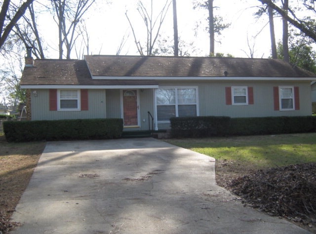
Updated 3 bedroom 1.5 bath home in NW Albany! Large den with pretty tiled floors, brick gas fireplace and built in entertainment center with bookshelves surrounding. Formal living and dining room, pretty kitchen, and spaciuos rooms. Gorgeous hardwood floors throughout most of the home. Outside you will find a screened in porch perfect for relaxing after a long day, covered patio, wired workshop, fenced backyard and 2 storage buildings! This home was update in 2004 with new wiring, HVAC, & roof! Call your Realtor today to see this home!
Last Agent to Sell the Property
Albany Realty Company Brokerage Phone: 2298836100 License #330612 Listed on: 05/01/2017
Last Buyer's Agent
Jewel Pettiford
Coldwell Banker Walden & Kirkland License #373195
| Date | Buyer | Sale Price | Title Company |
|---|---|---|---|
| Atkins Kendrick | $58,000 | -- | |
| Mckenzie Wanda C | -- | -- | |
| Mckenzie Wynton D | $38,700 | -- | |
| Security Bank & Trust Co Of Albany | $38,700 | -- | |
| Jr Bowles | -- | -- |
| Date | Status | Borrower | Loan Amount |
|---|---|---|---|
| Open | Atkins Kendrick | $56,949 |
| Date | Event | Price | List to Sale | Price per Sq Ft |
|---|---|---|---|---|
| 07/07/2017 07/07/17 | Sold | $58,000 | -- | $41 / Sq Ft |
| 05/01/2017 05/01/17 | Pending | -- | -- | -- |
| Year | Tax Paid | Tax Assessment Tax Assessment Total Assessment is a certain percentage of the fair market value that is determined by local assessors to be the total taxable value of land and additions on the property. | Land | Improvement |
|---|---|---|---|---|
| 2024 | $989 | $22,720 | $3,000 | $19,720 |
| 2023 | $127 | $22,720 | $3,000 | $19,720 |
| 2022 | $969 | $22,720 | $3,000 | $19,720 |
| 2021 | $898 | $22,720 | $3,000 | $19,720 |
| 2020 | $900 | $22,720 | $3,000 | $19,720 |
| 2019 | $904 | $22,720 | $3,000 | $19,720 |
| 2018 | $908 | $22,720 | $3,000 | $19,720 |
| 2017 | $653 | $22,720 | $3,000 | $19,720 |
| 2016 | $654 | $22,720 | $3,000 | $19,720 |
| 2015 | $655 | $22,720 | $3,000 | $19,720 |
| 2014 | $644 | $22,720 | $3,000 | $19,720 |
Seller's Agent in 2017
Susie Hardin
Albany Realty Company
(229) 291-3977
15 Total Sales
J
Buyer's Agent in 2017
Jewel Pettiford
Coldwell Banker Walden & Kirkland
Source: Albany Board of REALTORS®
MLS Number: 137589
APN: 0000Q-00012-002