Estimated Value: $382,000 - $471,544
3
Beds
3
Baths
3,550
Sq Ft
$120/Sq Ft
Est. Value
About This Home
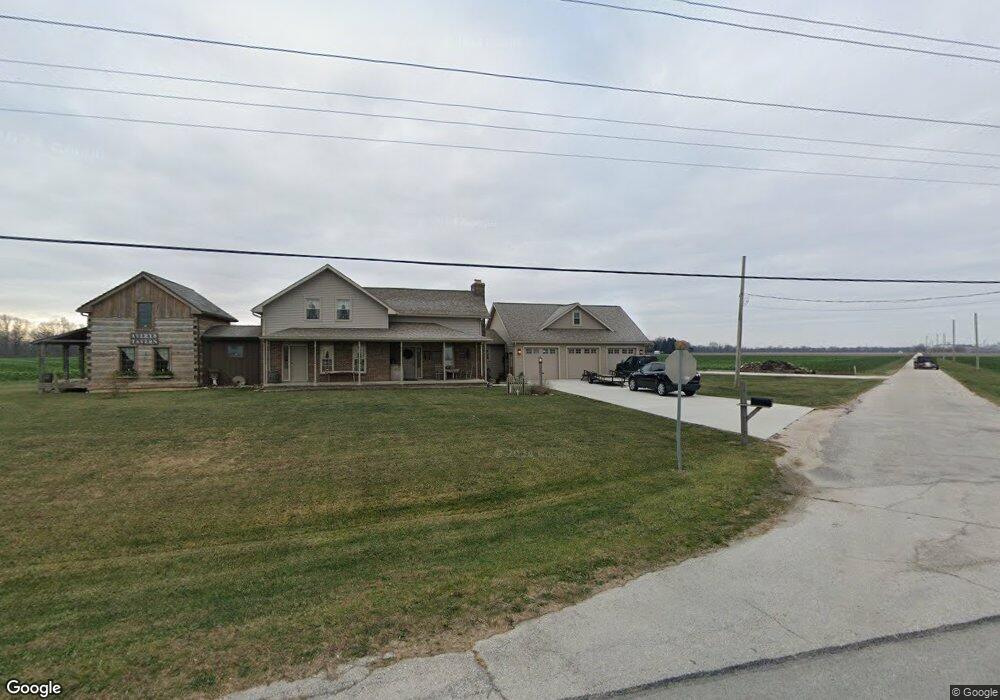
This home is located at 20250 State Route 51 W, Genoa, OH 43430 and is currently estimated at $427,136, approximately $120 per square foot. 20250 State Route 51 W is a home located in Ottawa County with nearby schools including Genoa Elementary School and Community Christian Academy.
Ownership History
Date
Name
Owned For
Owner Type
Purchase Details
Closed on
Aug 6, 2024
Sold by
Avery Douglas A and Avery Michele M
Bought by
Douglas And Michele Avery Joint Trust and Avery
Current Estimated Value
Purchase Details
Closed on
Feb 25, 2008
Sold by
Sievert Kenneth E and Sievert Patsy A
Bought by
Avery Douglas A and Avery Michele M
Purchase Details
Closed on
Sep 28, 2004
Sold by
Chasteen Oscar E and Chasteen Winnie M
Bought by
Sievert Kenneth E and Sievert Patsy A
Create a Home Valuation Report for This Property
The Home Valuation Report is an in-depth analysis detailing your home's value as well as a comparison with similar homes in the area
Home Values in the Area
Average Home Value in this Area
Purchase History
| Date | Buyer | Sale Price | Title Company |
|---|---|---|---|
| Douglas And Michele Avery Joint Trust | -- | None Listed On Document | |
| Avery Douglas A | -- | Attorney | |
| Sievert Kenneth E | $80,000 | Northwest Title Agency Of Oh |
Source: Public Records
Tax History Compared to Growth
Tax History
| Year | Tax Paid | Tax Assessment Tax Assessment Total Assessment is a certain percentage of the fair market value that is determined by local assessors to be the total taxable value of land and additions on the property. | Land | Improvement |
|---|---|---|---|---|
| 2024 | $6,441 | $136,515 | $17,007 | $119,508 |
| 2023 | $6,441 | $114,888 | $14,172 | $100,716 |
| 2022 | $5,921 | $109,810 | $14,172 | $95,638 |
| 2021 | $5,087 | $103,770 | $14,170 | $89,600 |
| 2020 | $3,588 | $68,710 | $10,120 | $58,590 |
| 2019 | $3,563 | $68,710 | $10,120 | $58,590 |
| 2018 | $2,331 | $45,300 | $10,120 | $35,180 |
| 2017 | $2,523 | $47,510 | $10,120 | $37,390 |
| 2016 | $2,532 | $47,510 | $10,120 | $37,390 |
| 2015 | $2,521 | $47,510 | $10,120 | $37,390 |
| 2014 | $1,111 | $44,110 | $10,120 | $33,990 |
| 2013 | $2,228 | $44,110 | $10,120 | $33,990 |
Source: Public Records
Map
Nearby Homes
- 19383 Courtland Ave
- 207 E 11th St
- 514 West St
- 904 Main St
- 1350 N Genoa Clay Center Rd
- 1301 West St
- 510 Wilson St
- 1861 N Opfer-Lentz Rd
- 416 Castle Cove
- 1615 N Thyre Dr
- 20240 W Portage River South Rd
- 0 W Portage River Rd S Unit 6130453
- 22771 W Holt Harrigan Rd
- 23225 Ohio 51
- 0 Recker Rd
- 23430 State Route 51 W
- 219 Lime St
- 212 S Perry St
- 110 E 1st St
- 612 W Main St
- 20250 Ohio 51
- 20250 W St Rt 51
- 20051 W Fulkert Rd
- 20021 W Fulkert Rd
- 20586 W Fulkert Rd
- 20111 W Hillside Dr
- 670 S Opfer Lentz Rd
- 20251 W Camper Rd
- 20020 W State Route 51
- 20357 W Camper Rd
- 20391 W Camper Rd
- 20423 W Camper Rd
- 20441 W Camper Rd
- 20483 W Camper Rd
- 20611 W Camper Rd
- 20440 W Camper Rd
- 20625 W Camper Rd
- 20480 W Camper Rd
- 20400 W Camper Rd
- 0 Camper (Lot A-4) Unit 4653700