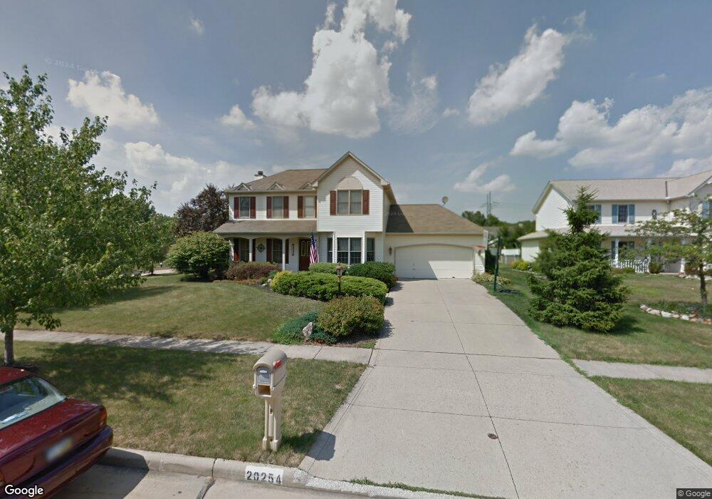
20254 Ashley Cir Strongsville, OH 44149
Estimated Value: $381,000 - $418,000
4
Beds
3
Baths
2,161
Sq Ft
$184/Sq Ft
Est. Value
About This Home
This home is located at 20254 Ashley Cir, Strongsville, OH 44149 and is currently estimated at $398,404, approximately $184 per square foot. 20254 Ashley Cir is a home located in Cuyahoga County with nearby schools including Strongsville High School, Sts Joseph & John Interparochial School, and St Mary School.
Ownership History
Date
Name
Owned For
Owner Type
Purchase Details
Closed on
Aug 10, 1994
Sold by
Golden Falcon Const Co
Bought by
Silva John R and Silva Angela R
Current Estimated Value
Home Financials for this Owner
Home Financials are based on the most recent Mortgage that was taken out on this home.
Original Mortgage
$143,000
Interest Rate
3.99%
Mortgage Type
New Conventional
Purchase Details
Closed on
May 19, 1994
Sold by
S N R
Bought by
Golden Falcon Const Co
Purchase Details
Closed on
Jan 1, 1993
Bought by
S N R
Create a Home Valuation Report for This Property
The Home Valuation Report is an in-depth analysis detailing your home's value as well as a comparison with similar homes in the area
Home Values in the Area
Average Home Value in this Area
Purchase History
| Date | Buyer | Sale Price | Title Company |
|---|---|---|---|
| Silva John R | $159,900 | -- | |
| Golden Falcon Const Co | $32,800 | -- | |
| S N R | -- | -- |
Source: Public Records
Mortgage History
| Date | Status | Borrower | Loan Amount |
|---|---|---|---|
| Closed | Silva John R | $143,000 |
Source: Public Records
Tax History Compared to Growth
Tax History
| Year | Tax Paid | Tax Assessment Tax Assessment Total Assessment is a certain percentage of the fair market value that is determined by local assessors to be the total taxable value of land and additions on the property. | Land | Improvement |
|---|---|---|---|---|
| 2024 | $5,885 | $125,335 | $21,700 | $103,635 |
| 2023 | $5,580 | $89,110 | $21,000 | $68,110 |
| 2022 | $5,539 | $89,110 | $21,000 | $68,110 |
| 2021 | $5,495 | $89,110 | $21,000 | $68,110 |
| 2020 | $5,647 | $80,990 | $19,080 | $61,920 |
| 2019 | $5,481 | $231,400 | $54,500 | $176,900 |
| 2018 | $4,974 | $80,990 | $19,080 | $61,920 |
| 2017 | $4,769 | $71,890 | $15,470 | $56,420 |
| 2016 | $4,730 | $71,890 | $15,470 | $56,420 |
| 2015 | $4,658 | $71,890 | $15,470 | $56,420 |
| 2014 | $4,658 | $69,800 | $15,020 | $54,780 |
Source: Public Records
Map
Nearby Homes
- 9401 Pheasant Run Place
- 20424 Scotch Pine Way
- 19890 Idlewood Trail
- 20050 Idlewood Trail
- 19997 Idlewood Trail
- 10986 Fawn Meadow Ln
- 21292 Creekside Dr
- 20684 Albion Rd
- 10839 Prospect Rd
- 8627 Courtland Dr
- 11179 Fawn Meadow Ln
- 19240 Briarwood Ln
- 10353 Oak Branch Trail
- 84 Sprague Rd
- 18737 Evergreen Dr
- 18433 Whitney Rd
- 11432 Pearl Rd
- 18203 Broxton Dr
- 104 Whitehall Dr
- 11499 Pearl Rd Unit A106
- 20242 Ashley Cir
- 20247 Homestead Park Dr
- 20230 Ashley Cir
- 20235 Homestead Park Dr
- 9420 Woodhurst Dr
- 9388 Woodhurst Dr
- 9452 Woodhurst Dr
- 9356 Woodhurst Dr
- 20223 Homestead Park Dr
- 20249 Ashley Cir
- 20237 Ashley Cir
- 9484 Woodhurst Dr
- 20218 Ashley Cir
- 9324 Woodhurst Dr
- 20211 Homestead Park Dr
- 20206 Ashley Cir
- 20225 Ashley Cir
- 9516 Woodhurst Dr
- 20213 Ashley Cir
- 20187 Homestead Park Dr