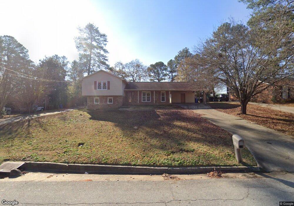
2026 Coventry Dr Columbus, GA 31904
North Columbus NeighborhoodEstimated Value: $235,088 - $261,000
4
Beds
3
Baths
2,214
Sq Ft
$113/Sq Ft
Est. Value
About This Home
This home is located at 2026 Coventry Dr, Columbus, GA 31904 and is currently estimated at $249,772, approximately $112 per square foot. 2026 Coventry Dr is a home located in Muscogee County with nearby schools including Allen Elementary School, Arnold Middle School, and Jordan Vocational High School.
Ownership History
Date
Name
Owned For
Owner Type
Purchase Details
Closed on
Sep 14, 2020
Sold by
Pridgen Helen W
Bought by
Willis Matthew and Jones Lay Dominique
Current Estimated Value
Home Financials for this Owner
Home Financials are based on the most recent Mortgage that was taken out on this home.
Original Mortgage
$132,554
Outstanding Balance
$117,633
Interest Rate
2.9%
Mortgage Type
FHA
Estimated Equity
$132,139
Create a Home Valuation Report for This Property
The Home Valuation Report is an in-depth analysis detailing your home's value as well as a comparison with similar homes in the area
Home Values in the Area
Average Home Value in this Area
Purchase History
We collect this data history from publicly available records. To have your information removed, we recommend requesting removal directly through your county’s website.
| Date | Buyer | Sale Price | Title Company |
|---|---|---|---|
| Willis Matthew | $67,500 | -- | |
| Willis Matthew | $67,000 | -- |
Source: Public Records
Mortgage History
We collect this data history from publicly available records. To have your information removed, we recommend requesting removal directly through your county’s website.
| Date | Status | Borrower | Loan Amount |
|---|---|---|---|
| Open | Willis Matthew | $132,554 | |
| Closed | Willis Matthew | $132,554 |
Source: Public Records
Tax History
| Year | Tax Paid | Tax Assessment Tax Assessment Total Assessment is a certain percentage of the fair market value that is determined by local assessors to be the total taxable value of land and additions on the property. | Land | Improvement |
|---|---|---|---|---|
| 2025 | $1,578 | $71,912 | $11,404 | $60,508 |
| 2024 | $158 | $71,912 | $11,404 | $60,508 |
| 2023 | $892 | $71,912 | $11,404 | $60,508 |
| 2022 | $1,644 | $57,336 | $11,404 | $45,932 |
| 2021 | $1,637 | $53,492 | $11,404 | $42,088 |
| 2020 | $446 | $53,492 | $11,404 | $42,088 |
| 2019 | $449 | $53,492 | $11,404 | $42,088 |
| 2018 | $449 | $53,492 | $11,404 | $42,088 |
| 2017 | $453 | $53,492 | $11,404 | $42,088 |
| 2016 | $456 | $54,498 | $8,601 | $45,897 |
| 2015 | $458 | $54,498 | $8,601 | $45,897 |
| 2014 | $461 | $54,498 | $8,601 | $45,897 |
| 2013 | -- | $54,498 | $8,601 | $45,897 |
Source: Public Records
Map
Nearby Homes
- 2119 Lancaster Dr
- 5239 23rd Ave
- 5224 23rd Ave
- 1906 Coventry Dr
- 2325 Coventry Dr
- 2201 Westminster Way
- 4814 20th Ave
- 4909 Saint Francis Ave
- 4830 17th Ave
- 4712 18th Ave
- 4521 19th Ave
- 1103 52nd St
- 5118 11th Ave
- 5106 11th Ave
- 5106 Kolb Ave
- 4344 Acacia Dr
- 2028 42nd St
- 1810 43rd St
- 1907 42nd St
- 2023 41st St
- 2116 Coventry Dr
- 2110 Coventry Dr
- 2102 Coventry Dr
- 2130 Coventry Dr
- 2117 Coventry Dr
- 2123 Coventry Dr
- 2111 Coventry Dr
- 2202 Coventry Dr
- 2131 Coventry Dr
- 2101 Coventry Dr
- 2201 Coventry Dr
- 2206 Coventry Dr
- 2118 Lancaster Dr
- 2124 Lancaster Dr
- 2112 Lancaster Dr
- 2130 Lancaster Dr
- 2207 Coventry Dr
- 2021 Coventry Dr
- 2102 Lancaster Dr
- 2214 Coventry Dr
Your Personal Tour Guide
Ask me questions while you tour the home.