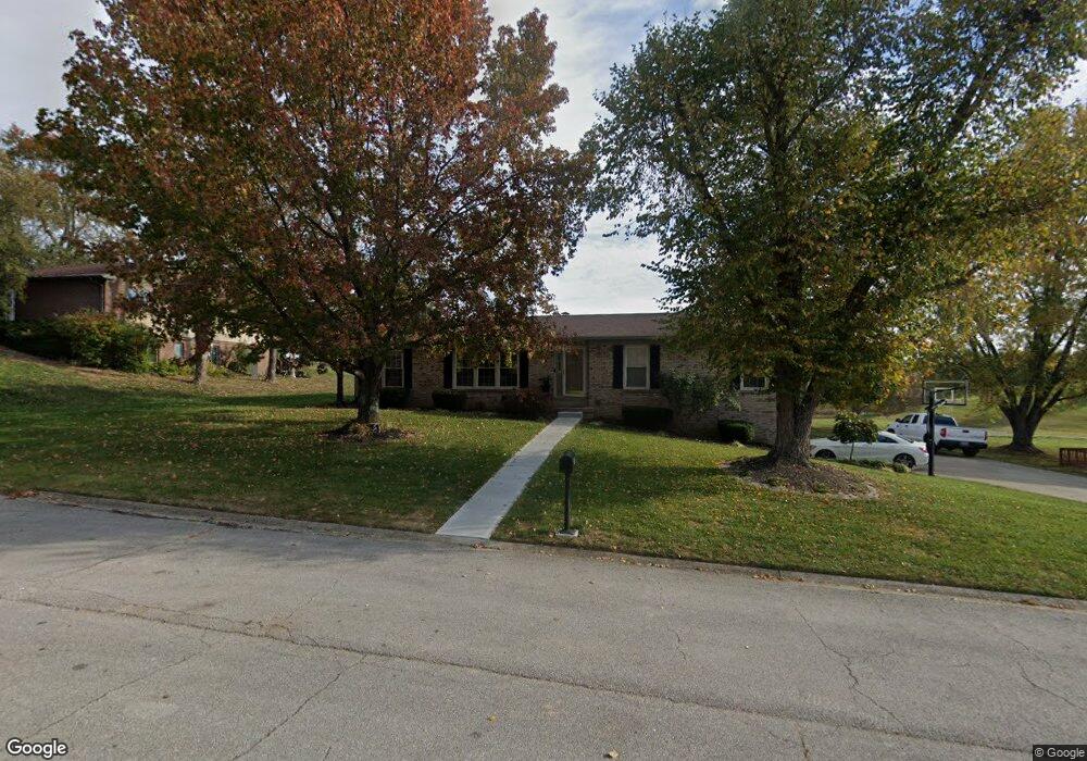
2026 Longview Dr Georgetown, KY 40324
Estimated Value: $338,000 - $393,000
4
Beds
3
Baths
2,909
Sq Ft
$125/Sq Ft
Est. Value
About This Home
This home is located at 2026 Longview Dr, Georgetown, KY 40324 and is currently estimated at $363,356, approximately $124 per square foot. 2026 Longview Dr is a home located in Scott County with nearby schools including Stamping Ground Elementary School, Royal Spring Middle School, and Scott County High School.
Ownership History
Date
Name
Owned For
Owner Type
Purchase Details
Closed on
Mar 9, 2022
Sold by
Weeks Michael O
Bought by
Weeks Michael O and Villalobos-Weeks Marisol
Current Estimated Value
Purchase Details
Closed on
Mar 22, 2013
Sold by
Weeks Lori A and Weeks Lori Ann
Bought by
Weeks Michael O and Weeks Michael O Neal
Home Financials for this Owner
Home Financials are based on the most recent Mortgage that was taken out on this home.
Original Mortgage
$157,000
Interest Rate
3.57%
Mortgage Type
New Conventional
Create a Home Valuation Report for This Property
The Home Valuation Report is an in-depth analysis detailing your home's value as well as a comparison with similar homes in the area
Purchase History
| Date | Buyer | Sale Price | Title Company |
|---|---|---|---|
| Weeks Michael O | -- | None Listed On Document | |
| Weeks Michael O | -- | None Available |
Source: Public Records
Mortgage History
| Date | Status | Borrower | Loan Amount |
|---|---|---|---|
| Previous Owner | Weeks Michael O | $157,000 |
Source: Public Records
Tax History
| Year | Tax Paid | Tax Assessment Tax Assessment Total Assessment is a certain percentage of the fair market value that is determined by local assessors to be the total taxable value of land and additions on the property. | Land | Improvement |
|---|---|---|---|---|
| 2025 | $2,665 | $299,200 | $0 | $0 |
| 2024 | $2,340 | $260,200 | $0 | $0 |
| 2023 | $2,242 | $247,300 | $30,000 | $217,300 |
| 2022 | $1,939 | $228,000 | $30,000 | $198,000 |
| 2021 | $1,872 | $213,400 | $30,000 | $183,400 |
| 2020 | $1,765 | $205,400 | $30,000 | $175,400 |
| 2019 | $1,731 | $198,300 | $0 | $0 |
| 2018 | $1,474 | $169,800 | $0 | $0 |
| 2017 | $1,403 | $160,884 | $0 | $0 |
| 2016 | $1,269 | $157,660 | $0 | $0 |
| 2015 | $1,235 | $154,400 | $0 | $0 |
| 2014 | $1,142 | $149,444 | $0 | $0 |
| 2011 | $1,086 | $149,444 | $0 | $0 |
Source: Public Records
Map
Nearby Homes
- 2020 Longview Dr
- 112 Lost Tree Dr
- 117 Windsong Way
- 3013 Fairway Ct
- 113 Shannon Ln
- 116 Shannon Ln
- 112 Fairfield Farm Rd
- 200 Victoria Way
- 115 Winding View Trail
- 169 Muir Ln
- 208 Craig Ln
- 364 Muir Ln
- 2553 Frankfort Pike
- 120 Creekside Dr
- 103 Locust Grove Dr
- 101 Sand Piper Ct
- 140 Seahawk Trail
- 106 Sand Piper Ct
- 3200 Fishers Mill Rd
- 133 Treetop Ct
- 2024 Longview Dr
- 2033 Longview Dr
- 2028 Longview Dr
- 2029 Longview Dr
- 2022 Longview Dr
- 2031 Longview Dr
- 2027 Longview Dr
- 2025 Longview Dr
- 120 Prater Dr
- 118 Prater Dr
- 132 Lost Tree Dr
- 122 Prater Dr
- 130 Lost Tree Dr
- 130 Lost Tree Dr Unit 198
- 116 Prater Dr
- 124 Prater Dr
- 112 Raccoon Run
- 114 Raccoon Run
- 131 Lost Tree Dr
- 2023 Longview Dr
Your Personal Tour Guide
Ask me questions while you tour the home.