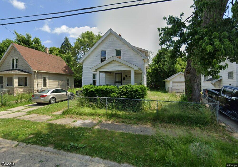
2027 Ferris Ave Flint, MI 48503
South Parks NeighborhoodEstimated Value: $47,000 - $57,000
3
Beds
1
Bath
1,108
Sq Ft
$46/Sq Ft
Est. Value
About This Home
This home is located at 2027 Ferris Ave, Flint, MI 48503 and is currently estimated at $50,667, approximately $45 per square foot. 2027 Ferris Ave is a home located in Genesee County with nearby schools including Freeman Elementary School, Flint Southwestern Classical Academy, and International Academy of Flint (K-12).
Ownership History
Date
Name
Owned For
Owner Type
Purchase Details
Closed on
Dec 22, 2023
Sold by
Puvvada Phani and Puvvada Sreedevi
Bought by
Sai Chakri Enterprises Llc
Current Estimated Value
Home Financials for this Owner
Home Financials are based on the most recent Mortgage that was taken out on this home.
Original Mortgage
$207,500
Outstanding Balance
$203,915
Interest Rate
7.29%
Mortgage Type
New Conventional
Estimated Equity
-$153,248
Purchase Details
Closed on
Sep 16, 2022
Sold by
Darrough Keith
Bought by
Puvvada Phani and Kavikondala Sreedevi
Create a Home Valuation Report for This Property
The Home Valuation Report is an in-depth analysis detailing your home's value as well as a comparison with similar homes in the area
Home Values in the Area
Average Home Value in this Area
Purchase History
We collect this data history from publicly available records. To have your information removed, we recommend requesting removal directly through your county’s website.
| Date | Buyer | Sale Price | Title Company |
|---|---|---|---|
| Sai Chakri Enterprises Llc | -- | Title Agency | |
| Puvvada Phani | $6,000 | -- |
Source: Public Records
Mortgage History
We collect this data history from publicly available records. To have your information removed, we recommend requesting removal directly through your county’s website.
| Date | Status | Borrower | Loan Amount |
|---|---|---|---|
| Open | Sai Chakri Enterprises Llc | $207,500 |
Source: Public Records
Tax History
| Year | Tax Paid | Tax Assessment Tax Assessment Total Assessment is a certain percentage of the fair market value that is determined by local assessors to be the total taxable value of land and additions on the property. | Land | Improvement |
|---|---|---|---|---|
| 2025 | $1,216 | $15,700 | $0 | $0 |
| 2024 | $1,124 | $13,300 | $0 | $0 |
| 2023 | $1,009 | $11,300 | $0 | $0 |
| 2022 | $0 | $9,900 | $0 | $0 |
| 2021 | $891 | $8,600 | $0 | $0 |
| 2020 | $655 | $8,400 | $0 | $0 |
| 2019 | $647 | $7,300 | $0 | $0 |
| 2018 | $617 | $6,800 | $0 | $0 |
| 2017 | $604 | $0 | $0 | $0 |
| 2016 | $600 | $0 | $0 | $0 |
| 2015 | -- | $0 | $0 | $0 |
| 2014 | -- | $0 | $0 | $0 |
| 2012 | -- | $7,400 | $0 | $0 |
Source: Public Records
Map
Nearby Homes
- 2041 Warner Ave
- 2050 Ferris Ave
- 2010 Crocker Ave
- 133 Orville St
- 533 E 12th St Unit 535
- 407 E 12th St
- 2117 S Saginaw St
- 2029 Winans Ave
- 2221 Howard Ave
- 1701 Park St
- 149 E Linsey Blvd
- 2109 Church St
- 133 E Oakley St
- 1610 Kent St
- 1771 Brookside Dr
- 2610 Pewanaga Place
- 810 E 8th St
- 2110 S Grand Traverse St
- 1847 Barks St
- 841 E 8th St
- 2023 Ferris Ave
- 2031 Ferris Ave
- 2017 Ferris Ave
- 2033 Ferris Ave
- 2026 Dwight Ave
- 2022 Dwight Ave
- 2030 Dwight Ave
- 2034 Dwight Ave
- 2026 Ferris Ave
- 2030 Ferris Ave
- 2038 Dwight Ave
- 2034 Ferris Ave
- 2018 Ferris Ave
- 2041 Ferris Ave
- 2009 Ferris Ave
- 2038 Ferris Ave
- 2042 Dwight Ave
- 2042 Ferris Ave
- 2010 Ferris Ave
- 2008 Dwight Ave
Your Personal Tour Guide
Ask me questions while you tour the home.