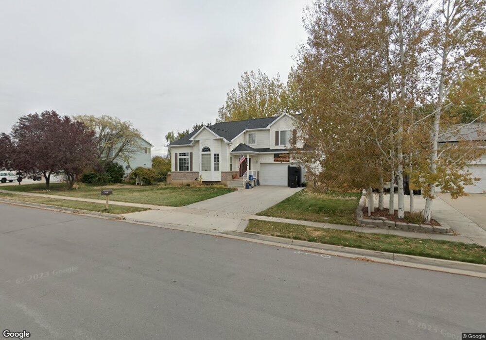
2029 Dahl Ln Syracuse, UT 84075
Estimated Value: $517,000 - $564,000
5
Beds
4
Baths
2,940
Sq Ft
$187/Sq Ft
Est. Value
About This Home
This home is located at 2029 Dahl Ln, Syracuse, UT 84075 and is currently estimated at $549,332, approximately $186 per square foot. 2029 Dahl Ln is a home located in Davis County with nearby schools including Cook School, Syracuse Junior High School, and Syracuse High School.
Ownership History
Date
Name
Owned For
Owner Type
Purchase Details
Closed on
Oct 14, 2016
Sold by
Mcgrody Shawn P and Mcgrody Pamela S
Bought by
Cottrell Colt L
Current Estimated Value
Purchase Details
Closed on
Oct 23, 2003
Sold by
Mcgrody Shawn P and Mcgrody Pamela A
Bought by
Mcgrody Shawn P and Mcgrody Pamela S
Home Financials for this Owner
Home Financials are based on the most recent Mortgage that was taken out on this home.
Original Mortgage
$144,450
Interest Rate
5.98%
Mortgage Type
Purchase Money Mortgage
Purchase Details
Closed on
Aug 30, 1996
Sold by
Watt Residential Partners
Bought by
Mcgrody Shawn P and Mcgrody Pamela A
Home Financials for this Owner
Home Financials are based on the most recent Mortgage that was taken out on this home.
Original Mortgage
$138,000
Interest Rate
8.23%
Create a Home Valuation Report for This Property
The Home Valuation Report is an in-depth analysis detailing your home's value as well as a comparison with similar homes in the area
Home Values in the Area
Average Home Value in this Area
Purchase History
| Date | Buyer | Sale Price | Title Company |
|---|---|---|---|
| Cottrell Colt L | -- | Backman Title | |
| Mcgrody Shawn P | -- | Inwest Title Services Inc | |
| Mcgrody Shawn P | -- | First American Title Co |
Source: Public Records
Mortgage History
| Date | Status | Borrower | Loan Amount |
|---|---|---|---|
| Previous Owner | Mcgrody Shawn P | $144,450 | |
| Previous Owner | Mcgrody Shawn P | $138,000 |
Source: Public Records
Tax History
| Year | Tax Paid | Tax Assessment Tax Assessment Total Assessment is a certain percentage of the fair market value that is determined by local assessors to be the total taxable value of land and additions on the property. | Land | Improvement |
|---|---|---|---|---|
| 2025 | $2,919 | $281,600 | $127,953 | $153,647 |
| 2024 | $2,803 | $272,250 | $108,737 | $163,513 |
| 2023 | $2,610 | $462,000 | $151,343 | $310,657 |
| 2022 | $2,817 | $273,350 | $86,715 | $186,635 |
| 2021 | $2,517 | $378,000 | $128,479 | $249,521 |
| 2020 | $2,249 | $327,000 | $110,452 | $216,548 |
| 2019 | $2,166 | $311,000 | $109,759 | $201,241 |
| 2018 | $1,986 | $283,000 | $105,034 | $177,966 |
| 2016 | $1,796 | $134,200 | $40,248 | $93,952 |
| 2015 | $1,722 | $122,540 | $40,248 | $82,292 |
| 2014 | $1,565 | $113,508 | $40,248 | $73,260 |
| 2013 | -- | $106,256 | $33,416 | $72,840 |
Source: Public Records
Map
Nearby Homes
Your Personal Tour Guide
Ask me questions while you tour the home.