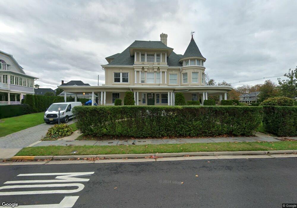
203 Allen Ave Allenhurst, NJ 07711
Estimated Value: $5,692,000 - $6,945,000
8
Beds
5
Baths
5,642
Sq Ft
$1,155/Sq Ft
Est. Value
About This Home
This home is located at 203 Allen Ave, Allenhurst, NJ 07711 and is currently estimated at $6,516,617, approximately $1,155 per square foot. 203 Allen Ave is a home located in Monmouth County with nearby schools including Hope Academy Charter School, St. Mary of the Assumption School, and Bnot Shirah of Deal.
Ownership History
Date
Name
Owned For
Owner Type
Purchase Details
Closed on
Apr 19, 2021
Sold by
Houllou Albert and Houllou Claudette Danielle
Bought by
Albert Houllou 2017 Life Insurance Trust and Houllou
Current Estimated Value
Purchase Details
Closed on
Oct 23, 2019
Sold by
Chera Isaac and Chera Carol
Bought by
Houllou Albert and Houllou Claudette Danielle
Home Financials for this Owner
Home Financials are based on the most recent Mortgage that was taken out on this home.
Original Mortgage
$3,500,000
Interest Rate
3.6%
Mortgage Type
New Conventional
Purchase Details
Closed on
Sep 17, 1997
Sold by
Vogel Christine
Bought by
Albert John
Home Financials for this Owner
Home Financials are based on the most recent Mortgage that was taken out on this home.
Original Mortgage
$270,000
Interest Rate
7.52%
Create a Home Valuation Report for This Property
The Home Valuation Report is an in-depth analysis detailing your home's value as well as a comparison with similar homes in the area
Home Values in the Area
Average Home Value in this Area
Purchase History
| Date | Buyer | Sale Price | Title Company |
|---|---|---|---|
| Albert Houllou 2017 Life Insurance Trust | -- | None Listed On Document | |
| Houllou Albert | $5,200,000 | Two Rivers Title Company Llc | |
| Albert John | $360,000 | -- |
Source: Public Records
Mortgage History
| Date | Status | Borrower | Loan Amount |
|---|---|---|---|
| Previous Owner | Houllou Albert | $3,500,000 | |
| Previous Owner | Albert John | $270,000 |
Source: Public Records
Tax History
| Year | Tax Paid | Tax Assessment Tax Assessment Total Assessment is a certain percentage of the fair market value that is determined by local assessors to be the total taxable value of land and additions on the property. | Land | Improvement |
|---|---|---|---|---|
| 2025 | $35,422 | $6,258,200 | $3,539,600 | $2,718,600 |
| 2024 | $32,084 | $6,014,000 | $3,303,200 | $2,710,800 |
| 2023 | $32,084 | $5,141,700 | $2,540,400 | $2,601,300 |
| 2022 | $31,232 | $4,582,600 | $2,209,700 | $2,372,900 |
| 2021 | $22,851 | $4,125,800 | $1,915,700 | $2,210,100 |
| 2020 | $24,315 | $3,073,900 | $1,793,400 | $1,280,500 |
| 2019 | $22,851 | $2,874,400 | $1,601,300 | $1,273,100 |
| 2018 | $22,409 | $2,815,200 | $1,601,300 | $1,213,900 |
| 2017 | $20,780 | $2,670,900 | $1,523,600 | $1,147,300 |
| 2016 | $19,693 | $2,366,900 | $1,398,700 | $968,200 |
| 2015 | $19,243 | $2,087,100 | $1,248,800 | $838,300 |
| 2014 | $21,661 | $2,548,400 | $1,560,600 | $987,800 |
Source: Public Records
Map
Nearby Homes
- 110 Corlies Ave Unit A
- 127 Cedar Ave
- 48 Neptune Ave
- 315 Allen Ave
- 25 Cedar Ave
- 205 Edgemont Dr Unit 1
- 205 Edgemont Dr Unit 2
- 205 Edgemont Dr Unit 3
- 205 Edgemont Dr Unit BUILDING
- 112 Euclid Ave
- 309 Hume St
- 400 Deal Lake Dr Unit 3J
- 400 Deal Lake Dr Unit 6G
- 400 Deal Lake Dr Unit 2L
- 400 Deal Lake Dr Unit 8F
- 400 Deal Lake Dr Unit 7H & 7G
- 400 Deal Lake Dr Unit 6E
- 400 Deal Lake Dr Unit 3K
- 57 Hathaway Ave
- 304 Deal Lake Dr Unit 35
- 207 Allen Ave
- 204 Corlies Ave
- 208 Corlies Ave
- 309 Norwood Ave S
- 204 Allen Ave
- 55 Norwood Ave S
- 303 Norwood Ave S
- 212 Corlies Ave
- 211 Allen Ave
- 118 Allen Ave
- 210 Allen Ave
- 120 Corlies Ave
- 214 Allen Ave
- 216 Corlies Ave
- 117 Allen Ave
- 203 Corlies Ave
- 42 Norwood Ave S
- 216 Allen Ave
- 118 Corlies Ave
- 45 Norwood Ave S
Your Personal Tour Guide
Ask me questions while you tour the home.