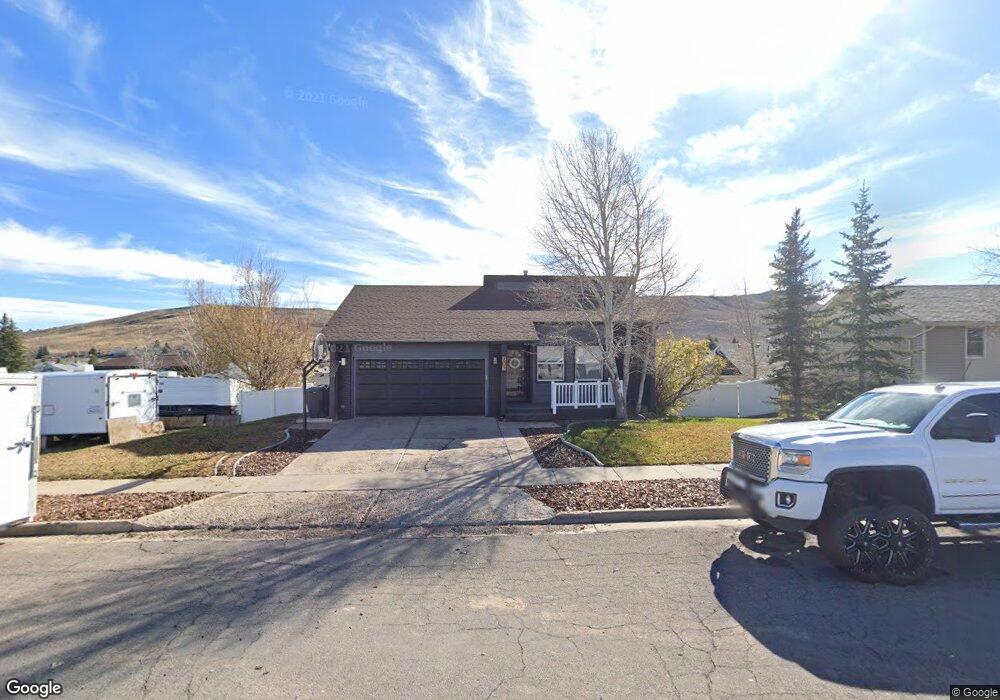
203 Bodine Ave Evanston, WY 82930
Estimated Value: $405,000 - $490,000
5
Beds
3
Baths
1,319
Sq Ft
$326/Sq Ft
Est. Value
About This Home
This home is located at 203 Bodine Ave, Evanston, WY 82930 and is currently estimated at $429,986, approximately $325 per square foot. 203 Bodine Ave is a home located in Uinta County with nearby schools including Evanston High School and Evanston Child Development Center.
Ownership History
Date
Name
Owned For
Owner Type
Purchase Details
Closed on
Jan 7, 2020
Sold by
Lym Dustin
Bought by
Lym Dustin and Lym Antoreln
Current Estimated Value
Purchase Details
Closed on
Jun 20, 2014
Sold by
Lym Dustin L and Lym Brook R
Bought by
Lym Dustin L
Home Financials for this Owner
Home Financials are based on the most recent Mortgage that was taken out on this home.
Original Mortgage
$170,000
Interest Rate
4.23%
Mortgage Type
New Conventional
Create a Home Valuation Report for This Property
The Home Valuation Report is an in-depth analysis detailing your home's value as well as a comparison with similar homes in the area
Home Values in the Area
Average Home Value in this Area
Purchase History
| Date | Buyer | Sale Price | Title Company |
|---|---|---|---|
| Lym Dustin | -- | None Available | |
| Lym Antonela | -- | None Listed On Document | |
| Lym Dustin L | -- | First American Title Ins Co |
Source: Public Records
Mortgage History
| Date | Status | Borrower | Loan Amount |
|---|---|---|---|
| Previous Owner | Lym Dustin L | $170,000 |
Source: Public Records
Tax History Compared to Growth
Tax History
| Year | Tax Paid | Tax Assessment Tax Assessment Total Assessment is a certain percentage of the fair market value that is determined by local assessors to be the total taxable value of land and additions on the property. | Land | Improvement |
|---|---|---|---|---|
| 2025 | $2,273 | $25,869 | $5,639 | $20,230 |
| 2024 | $2,273 | $33,443 | $7,519 | $25,924 |
| 2023 | $2,195 | $32,449 | $7,519 | $24,930 |
| 2022 | $2,095 | $30,775 | $6,300 | $24,475 |
| 2021 | $1,688 | $24,763 | $6,178 | $18,585 |
| 2020 | $1,666 | $24,457 | $6,178 | $18,279 |
| 2019 | $1,592 | $23,406 | $6,178 | $17,228 |
| 2018 | $1,043 | $21,155 | $4,731 | $16,424 |
| 2017 | $1,383 | $20,362 | $4,306 | $16,056 |
| 2016 | $1,339 | $19,689 | $4,306 | $15,383 |
| 2015 | -- | $18,972 | $4,306 | $14,666 |
| 2014 | -- | $19,520 | $0 | $0 |
Source: Public Records
Map
Nearby Homes
- 479 Twin Ridge Ave
- 405, 411, & 419 Burns Ave
- 427 Thayer Cir
- 223 Barber Ave
- 221 Barber Ave
- 405 Burns Ave Unit 3,4,5
- 413 Crane Ave
- 113 Tower Rd
- 115 Peak Rd
- 116 Peak Rd
- 3925 Yellow Creek Rd
- 3893 Yellow Creek Rd
- 3861 Yellow Creek Rd
- 3827 Yellow Creek Rd
- 824 9th St
- 633 9th St
- 819 Walton Ave
- 525 8th St
- 310 Ottley Dr
- 325 Davis Dr
- 207 Bodine Ave
- 204 Champs Ave
- 204 Champs Ave Unit Twin Ridge
- 208 Champs Ave
- 200 Champs Ave
- 211 Bodine Ave
- 212 Champs Ave
- 201 Champs Ave
- 217 Bodine Ave
- 205 Champs Ave
- 218 Champs Ave
- 209 Champs Ave
- 213 Champs Ave
- 645 Twin Ridge Ave
- 204 Florence Ave
- 208 Florence Ave
- 217 Champs Ave
- 223 Bodine Ave
- 212 Florence Ave
- 200 Florence Ave