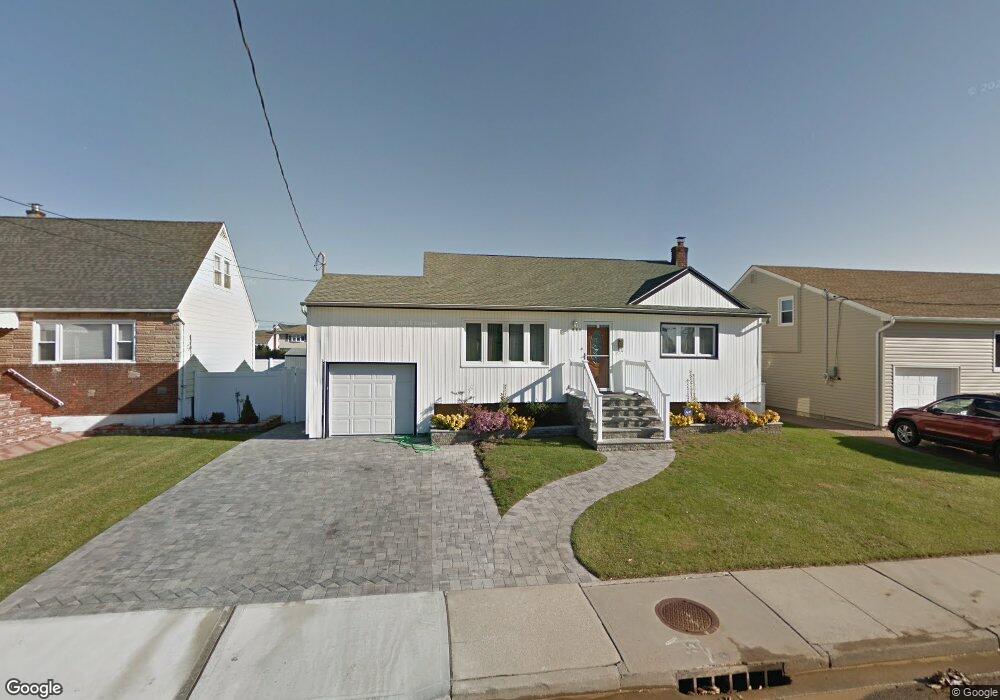
203 Branch Ave Freeport, NY 11520
Estimated Value: $507,000 - $641,328
--
Bed
2
Baths
952
Sq Ft
$603/Sq Ft
Est. Value
About This Home
This home is located at 203 Branch Ave, Freeport, NY 11520 and is currently estimated at $574,164, approximately $603 per square foot. 203 Branch Ave is a home located in Nassau County with nearby schools including Columbus Avenue School, Caroline G. Atkinson Intermediate School, and John W Dodd Middle School.
Ownership History
Date
Name
Owned For
Owner Type
Purchase Details
Closed on
Feb 3, 2014
Sold by
Doshi Daivesh B
Bought by
Deamorim Gilsomar and Deamorim Pamela
Current Estimated Value
Home Financials for this Owner
Home Financials are based on the most recent Mortgage that was taken out on this home.
Original Mortgage
$209,706
Outstanding Balance
$157,934
Interest Rate
4.25%
Mortgage Type
FHA
Estimated Equity
$416,230
Purchase Details
Closed on
Mar 14, 1997
Sold by
Citibank Na
Bought by
Doshi Daivesh B
Purchase Details
Closed on
Mar 5, 1996
Create a Home Valuation Report for This Property
The Home Valuation Report is an in-depth analysis detailing your home's value as well as a comparison with similar homes in the area
Home Values in the Area
Average Home Value in this Area
Purchase History
| Date | Buyer | Sale Price | Title Company |
|---|---|---|---|
| Deamorim Gilsomar | $229,000 | Stewart Title Insurance | |
| Doshi Daivesh B | $114,400 | -- | |
| -- | $151,882 | -- |
Source: Public Records
Mortgage History
| Date | Status | Borrower | Loan Amount |
|---|---|---|---|
| Open | Deamorim Gilsomar | $209,706 |
Source: Public Records
Tax History Compared to Growth
Tax History
| Year | Tax Paid | Tax Assessment Tax Assessment Total Assessment is a certain percentage of the fair market value that is determined by local assessors to be the total taxable value of land and additions on the property. | Land | Improvement |
|---|---|---|---|---|
| 2025 | $7,038 | $368 | $152 | $216 |
| 2024 | $781 | $365 | $151 | $214 |
| 2023 | $6,420 | $384 | $159 | $225 |
| 2022 | $6,420 | $371 | $153 | $218 |
| 2021 | $8,412 | $369 | $153 | $216 |
| 2020 | $5,761 | $448 | $426 | $22 |
| 2019 | $5,254 | $480 | $352 | $128 |
| 2018 | $5,514 | $622 | $0 | $0 |
| 2017 | $6,086 | $622 | $456 | $166 |
| 2016 | $7,019 | $622 | $456 | $166 |
| 2015 | $899 | $622 | $456 | $166 |
| 2014 | $899 | $622 | $456 | $166 |
| 2013 | $807 | $591 | $433 | $158 |
Source: Public Records
Map
Nearby Homes
- 587 S Bayview Ave
- 226 Westside Ave Unit B
- 159 Branch Ave
- 292 Westside Ave
- 171 Westside Ave
- 300 Branch Ave
- 28 Florence Ave
- 214 Westend Ave Unit 6c
- 210 Westend Ave Unit 8B
- 8 Florence Ave Unit 16C
- 106 Irving Ave
- 479 Roosevelt Ave
- 31 Casino St Unit PH
- 59 Hampton Place Unit 20D
- 77 Hampton Place
- 153 Westend Ave
- 232 Nassau Ave
- 16 Johnson Place
- 173 Cedar St
- 1116 Washington Place
- 193 Branch Ave
- 207 Branch Ave
- 232 Saint Marks Ave
- 240 Saint Marks Ave
- 213 Branch Ave
- 1 Branch Ave
- 244 Saint Marks Ave
- 200 Branch Ave
- 222 Saint Marks Ave
- 194 Branch Ave
- 189 Branch Ave
- 188 Branch Ave
- 250 Saint Marks Ave
- 183 Branch Ave
- 221 Branch Ave
- 218 Saint Marks Ave
- 617 S Bayview Ave
- 621 S Bayview Ave
- 184 Branch Ave
- 256 Saint Marks Ave