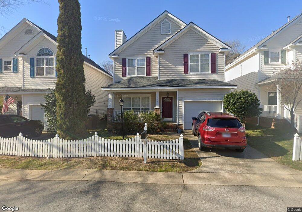
203 Bridgepath Dr Cary, NC 27513
North Cary NeighborhoodEstimated Value: $387,000 - $458,000
3
Beds
3
Baths
1,641
Sq Ft
$264/Sq Ft
Est. Value
About This Home
This home is located at 203 Bridgepath Dr, Cary, NC 27513 and is currently estimated at $433,990, approximately $264 per square foot. 203 Bridgepath Dr is a home located in Wake County with nearby schools including Northwoods Elementary School, West Cary Middle School, and Cary High School.
Ownership History
Date
Name
Owned For
Owner Type
Purchase Details
Closed on
Feb 16, 2026
Sold by
Hawley Caitlin Ann and Liotta Jay Robert
Bought by
Hawley Liotta Living Trust and Hawley
Current Estimated Value
Purchase Details
Closed on
Mar 15, 2005
Sold by
Ly Cuong Thanh and Tran Thu Nguyget
Bought by
Byrd Gregory S and Byrd Laura S
Home Financials for this Owner
Home Financials are based on the most recent Mortgage that was taken out on this home.
Original Mortgage
$156,700
Interest Rate
5.6%
Mortgage Type
Fannie Mae Freddie Mac
Create a Home Valuation Report for This Property
The Home Valuation Report is an in-depth analysis detailing your home's value as well as a comparison with similar homes in the area
Home Values in the Area
Average Home Value in this Area
Purchase History
| Date | Buyer | Sale Price | Title Company |
|---|---|---|---|
| Hawley Liotta Living Trust | -- | None Listed On Document | |
| Byrd Gregory S | $162,000 | -- |
Source: Public Records
Mortgage History
| Date | Status | Borrower | Loan Amount |
|---|---|---|---|
| Previous Owner | Byrd Gregory S | $156,700 |
Source: Public Records
Tax History
| Year | Tax Paid | Tax Assessment Tax Assessment Total Assessment is a certain percentage of the fair market value that is determined by local assessors to be the total taxable value of land and additions on the property. | Land | Improvement |
|---|---|---|---|---|
| 2025 | $3,949 | $458,392 | $150,000 | $308,392 |
| 2024 | $3,864 | $458,392 | $150,000 | $308,392 |
| 2023 | $2,812 | $278,670 | $76,000 | $202,670 |
| 2022 | $2,708 | $278,670 | $76,000 | $202,670 |
| 2021 | $2,653 | $278,670 | $76,000 | $202,670 |
| 2020 | $2,667 | $278,670 | $76,000 | $202,670 |
| 2019 | $2,378 | $220,273 | $62,000 | $158,273 |
| 2018 | $2,232 | $220,273 | $62,000 | $158,273 |
| 2017 | $2,146 | $220,273 | $62,000 | $158,273 |
| 2016 | $2,114 | $220,273 | $62,000 | $158,273 |
| 2015 | -- | $175,676 | $46,000 | $129,676 |
| 2014 | $1,650 | $175,676 | $46,000 | $129,676 |
Source: Public Records
Map
Nearby Homes
- 1109 Laurel Twist Rd
- 845 Rymark Ct
- 902 Green Ash Ln
- 1103 Laurel Twist Rd
- 1005 Rexburg Dr
- 107 Carnie Ct
- 102 Anna Lake Ln
- 1624 Wilson Rd
- 1025 Evans Rd
- 788 Ballyneal Aly
- 784 Ballyneal Aly
- 203 Rose Valley Woods Dr
- 768 Ballyneal Aly
- 766 Ballyneal Aly
- 770 Ballyneal Aly
- 786 Ballyneal Aly
- 772 Ballyneal Aly
- 780 Ballyneal Aly
- 778 Ballyneal Aly
- 774 Ballyneal Aly
- 201 Bridgepath Dr
- 205 Bridgepath Dr
- 201 Reedhaven Dr
- 209 Bridgepath Dr
- 107 Bridgepath Dr
- 203 Reedhaven Dr
- 211 Bridgepath Dr
- 210 Bridgepath Dr
- 105 Bridgepath Dr
- 200 Reedhaven Dr
- 213 Bridgepath Dr
- 212 Bridgepath Dr
- 204 Reedhaven Dr
- 103 Bridgepath Dr
- 215 Bridgepath Dr
- 214 Bridgepath Dr
- 100 Bridgepath Dr
- 200 Pinner Weald Way Unit 102
- 101 Bridgepath Dr
- 1505 Fairbanks Rd
Your Personal Tour Guide
Ask me questions while you tour the home.