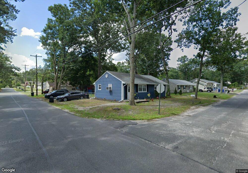
203 Daniels Ave Browns Mills, NJ 08015
Estimated Value: $287,027 - $325,000
--
Bed
--
Bath
1,040
Sq Ft
$288/Sq Ft
Est. Value
About This Home
This home is located at 203 Daniels Ave, Browns Mills, NJ 08015 and is currently estimated at $300,007, approximately $288 per square foot. 203 Daniels Ave is a home located in Burlington County.
Ownership History
Date
Name
Owned For
Owner Type
Purchase Details
Closed on
Jul 22, 2002
Sold by
Ratti John and Otten Angella
Bought by
Dunston Norma J
Current Estimated Value
Home Financials for this Owner
Home Financials are based on the most recent Mortgage that was taken out on this home.
Original Mortgage
$89,195
Outstanding Balance
$37,180
Interest Rate
6.61%
Mortgage Type
Purchase Money Mortgage
Estimated Equity
$262,827
Purchase Details
Closed on
Apr 3, 2001
Sold by
Dagostino Thomas
Bought by
Ratti John W and Otten Angela S
Home Financials for this Owner
Home Financials are based on the most recent Mortgage that was taken out on this home.
Original Mortgage
$81,250
Interest Rate
7.05%
Mortgage Type
FHA
Purchase Details
Closed on
Oct 31, 2000
Sold by
Wells Fargo Bank Minnesota Na
Bought by
Dagostino Thomas
Purchase Details
Closed on
Oct 13, 2000
Sold by
Bankers Trust Company Of California Na
Bought by
Norwest Bank Minnesota Na
Purchase Details
Closed on
Dec 13, 1999
Sold by
Ponton Joyce D and Dishert Raymond
Bought by
Bankers Trust Company Of California Na
Create a Home Valuation Report for This Property
The Home Valuation Report is an in-depth analysis detailing your home's value as well as a comparison with similar homes in the area
Home Values in the Area
Average Home Value in this Area
Purchase History
| Date | Buyer | Sale Price | Title Company |
|---|---|---|---|
| Dunston Norma J | $89,900 | Congress Title Corp | |
| Ratti John W | $81,900 | Surety Title Corporation | |
| Dagostino Thomas | $40,000 | Surety Title Corporation | |
| Norwest Bank Minnesota Na | -- | Surety Title Corporation | |
| Bankers Trust Company Of California Na | -- | -- |
Source: Public Records
Mortgage History
| Date | Status | Borrower | Loan Amount |
|---|---|---|---|
| Open | Dunston Norma J | $89,195 | |
| Previous Owner | Ratti John W | $81,250 |
Source: Public Records
Tax History Compared to Growth
Tax History
| Year | Tax Paid | Tax Assessment Tax Assessment Total Assessment is a certain percentage of the fair market value that is determined by local assessors to be the total taxable value of land and additions on the property. | Land | Improvement |
|---|---|---|---|---|
| 2025 | $3,948 | $128,800 | $38,000 | $90,800 |
| 2024 | $3,704 | $128,800 | $38,000 | $90,800 |
| 2023 | $3,704 | $128,800 | $38,000 | $90,800 |
| 2022 | $3,429 | $128,800 | $38,000 | $90,800 |
| 2021 | $3,038 | $128,800 | $38,000 | $90,800 |
| 2020 | $3,165 | $128,800 | $38,000 | $90,800 |
| 2019 | $3,031 | $128,800 | $38,000 | $90,800 |
| 2018 | $2,928 | $128,800 | $38,000 | $90,800 |
| 2017 | $2,867 | $128,800 | $38,000 | $90,800 |
| 2016 | $2,815 | $75,300 | $19,600 | $55,700 |
| 2015 | $2,792 | $75,300 | $19,600 | $55,700 |
| 2014 | $2,669 | $75,300 | $19,600 | $55,700 |
Source: Public Records
Map
Nearby Homes
- 213 Daniels Ave
- 191 Daniels Ave
- 202 Pardee Blvd
- 212 Daniels Ave
- 218 Pardee Blvd
- 1101 Hunter Blvd
- 219 Daniels Ave
- 218 Daniels Ave
- 186 Daniels Ave
- 177 Daniels Ave
- 190 Pardee Blvd
- 226 Pardee Blvd
- 226 Daniels Ave
- 1103 Hunter Blvd
- 903 Hunter Blvd
- 227 Daniels Ave
- 213 Curtin Ave
- 189 Pardee Blvd
- 182 Pardee Blvd
- 234 Pardee Blvd