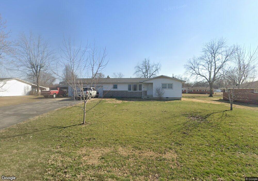
203 Depot Rd Bloomfield, MO 63825
Estimated Value: $162,672 - $191,000
3
Beds
2
Baths
1,440
Sq Ft
$123/Sq Ft
Est. Value
About This Home
This home is located at 203 Depot Rd, Bloomfield, MO 63825 and is currently estimated at $176,418, approximately $122 per square foot. 203 Depot Rd is a home with nearby schools including Bloomfield Elementary School, Bloomfield Middle School, and Bloomfield High School.
Ownership History
Date
Name
Owned For
Owner Type
Purchase Details
Closed on
Jun 25, 2018
Sold by
Bryce Hill and Bryce Cara
Bought by
Bryeans Ethan T
Current Estimated Value
Home Financials for this Owner
Home Financials are based on the most recent Mortgage that was taken out on this home.
Original Mortgage
$84,242
Outstanding Balance
$72,855
Interest Rate
4.5%
Mortgage Type
New Conventional
Estimated Equity
$103,563
Create a Home Valuation Report for This Property
The Home Valuation Report is an in-depth analysis detailing your home's value as well as a comparison with similar homes in the area
Purchase History
| Date | Buyer | Sale Price | Title Company |
|---|---|---|---|
| Bryeans Ethan T | $105,302 | Countywide Abs & Title Inc |
Source: Public Records
Mortgage History
| Date | Status | Borrower | Loan Amount |
|---|---|---|---|
| Open | Bryeans Ethan T | $84,242 |
Source: Public Records
Tax History
| Year | Tax Paid | Tax Assessment Tax Assessment Total Assessment is a certain percentage of the fair market value that is determined by local assessors to be the total taxable value of land and additions on the property. | Land | Improvement |
|---|---|---|---|---|
| 2025 | $726 | $14,611 | $0 | $0 |
| 2024 | $7 | $13,490 | $0 | $0 |
| 2023 | $726 | $13,490 | $0 | $0 |
| 2022 | $682 | $12,673 | $0 | $0 |
| 2021 | $682 | $12,673 | $0 | $0 |
| 2020 | $580 | $11,419 | $0 | $0 |
| 2019 | $580 | $12,312 | $0 | $0 |
| 2018 | $537 | $11,419 | $0 | $0 |
| 2016 | $523 | $11,115 | $0 | $0 |
| 2015 | -- | $11,115 | $0 | $0 |
| 2014 | -- | $11,020 | $0 | $0 |
| 2013 | -- | $0 | $0 | $0 |
Source: Public Records
Map
Nearby Homes
- 301 Cape Rd
- 404 Locust St
- 306R Miller St
- 301 W Shawnee St
- E Highway
- 707 S Prairie St
- 16501 County Road 420
- 0 E Hwy Unit MIS26003606
- 22348 County Road 503
- 21895 County Road 550
- 0 County Road 237
- 14671 Frontage Rd
- 15676 State Highway Ad
- 14089 County Road 405
- 14038 County Road 405
- 14033 County Road 405
- 13920 County Road 403
- 25097 State Highway 25
- 17173 E Cedar Hills Dr
- 0 E Kenton Rd Unit MAR25009938
- 201 Depot Rd
- 301 Depot Rd
- 206 Christian Dr
- 204 Christian Dr
- 300 Christian Dr
- 202 Christian Dr
- 905 N Prairie St
- 303 Depot Rd
- 301 Christian Dr
- 301 Christian Dr
- 901 N Prairie St
- 801 N Prairie St
- 401 Depot Rd
- 708 N Spring St
- 715 Allie St
- 904 N Prairie St
- 403 Depot Rd
- 713 N Prairie St
- 707 N Spring St
- 707 N Spring St
Your Personal Tour Guide
Ask me questions while you tour the home.