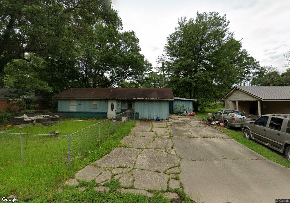
203 Gibson Cir Dermott, AR 71638
Estimated Value: $55,000 - $102,000
--
Bed
1
Bath
1,896
Sq Ft
$41/Sq Ft
Est. Value
About This Home
This home is located at 203 Gibson Cir, Dermott, AR 71638 and is currently estimated at $77,013, approximately $40 per square foot. 203 Gibson Cir is a home located in Chicot County with nearby schools including Dermott Elementary School and Dermott High School.
Ownership History
Date
Name
Owned For
Owner Type
Purchase Details
Closed on
Aug 1, 2016
Sold by
Paris Karen L
Bought by
Esters Marvin
Current Estimated Value
Home Financials for this Owner
Home Financials are based on the most recent Mortgage that was taken out on this home.
Original Mortgage
$14,543
Outstanding Balance
$11,617
Interest Rate
3.6%
Mortgage Type
New Conventional
Estimated Equity
$65,396
Purchase Details
Closed on
Apr 8, 2008
Bought by
Esters Marvin
Purchase Details
Closed on
Aug 20, 2003
Bought by
Marvin and Pamela Esters
Purchase Details
Closed on
Oct 18, 2000
Bought by
United Companies Lending Corp
Purchase Details
Closed on
Jun 1, 1975
Bought by
Arnn James Lee
Purchase Details
Closed on
Sep 12, 1902
Bought by
Clarissa Phillips Etvir
Create a Home Valuation Report for This Property
The Home Valuation Report is an in-depth analysis detailing your home's value as well as a comparison with similar homes in the area
Home Values in the Area
Average Home Value in this Area
Purchase History
| Date | Buyer | Sale Price | Title Company |
|---|---|---|---|
| Esters Marvin | -- | -- | |
| Esters Marvin | $25,000 | -- | |
| Marvin | -- | -- | |
| United Companies Lending Corp | $22,800 | -- | |
| Arnn James Lee | -- | -- | |
| Clarissa Phillips Etvir | $39,000 | -- |
Source: Public Records
Mortgage History
| Date | Status | Borrower | Loan Amount |
|---|---|---|---|
| Open | Esters Marvin | $14,543 | |
| Previous Owner | Clarissa Phillips Etvir | $0 | |
| Previous Owner | Clarissa Phillips Etvir | $0 |
Source: Public Records
Tax History Compared to Growth
Tax History
| Year | Tax Paid | Tax Assessment Tax Assessment Total Assessment is a certain percentage of the fair market value that is determined by local assessors to be the total taxable value of land and additions on the property. | Land | Improvement |
|---|---|---|---|---|
| 2025 | $499 | $10,200 | $380 | $9,820 |
| 2024 | $499 | $10,200 | $380 | $9,820 |
| 2023 | $435 | $11,160 | $380 | $10,780 |
| 2022 | $163 | $11,160 | $380 | $10,780 |
| 2021 | $145 | $11,160 | $380 | $10,780 |
| 2020 | $399 | $11,160 | $380 | $10,780 |
| 2019 | $106 | $11,160 | $380 | $10,780 |
| 2018 | $69 | $6,440 | $600 | $5,840 |
| 2017 | $363 | $6,440 | $600 | $5,840 |
| 2016 | $63 | $6,440 | $600 | $5,840 |
| 2015 | -- | $6,440 | $600 | $5,840 |
| 2014 | -- | $6,440 | $600 | $5,840 |
| 2013 | -- | $6,440 | $600 | $5,840 |
Source: Public Records
Map
Nearby Homes
- 15 Maulding Dr
- 0 0 Unit N Norwood St
- 0 N Trotter St
- 0 Wolfe St
- Lot 6 N Alma St
- Lot 5 Deer St
- Lot 12 W Mulberry St
- 0 W Mulberry St
- 0 N Hardy St
- Lot 7 W Matthews St
- Lots 8-9 S Gerald Davis Ln
- 608 Highway 35 S
- Vacant land Cater Ln
- 1104 U S 65
- 604 Highway 65 S
- 22 Orlando Dr
- 6 Paul St
- 109 Ashcraft St
- Lots 6-7 Bush St
- Lot 2 Cypress Gardens