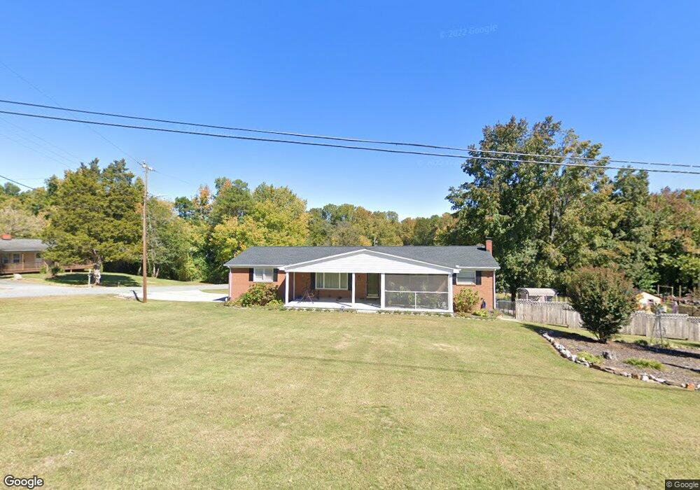
203 Lakeview Ave High Point, NC 27263
Greater High Point NeighborhoodEstimated Value: $232,000 - $258,000
3
Beds
2
Baths
1,288
Sq Ft
$188/Sq Ft
Est. Value
About This Home
This home is located at 203 Lakeview Ave, High Point, NC 27263 and is currently estimated at $241,638, approximately $187 per square foot. 203 Lakeview Ave is a home located in Guilford County with nearby schools including Allen Jay Elementary School, Southern Guilford Middle, and Southern Guilford High School.
Ownership History
Date
Name
Owned For
Owner Type
Purchase Details
Closed on
Nov 1, 2023
Sold by
Wrenn Cynthia Smith
Bought by
Sheffield Dalan Michael and Sheffield Timothy Neil
Current Estimated Value
Purchase Details
Closed on
Dec 18, 2019
Sold by
Wrenn Eli Franklin and Wrenn Cynthia Smith
Bought by
Wrenn Eli Franklin and Wrenn Cynthia Smith
Purchase Details
Closed on
Apr 20, 1989
Bought by
Wrenn Eli Franklin
Create a Home Valuation Report for This Property
The Home Valuation Report is an in-depth analysis detailing your home's value as well as a comparison with similar homes in the area
Home Values in the Area
Average Home Value in this Area
Purchase History
| Date | Buyer | Sale Price | Title Company |
|---|---|---|---|
| Sheffield Dalan Michael | -- | None Listed On Document | |
| Wrenn Eli Franklin | -- | None Available | |
| Wrenn Eli Franklin | $65,600 | -- |
Source: Public Records
Tax History Compared to Growth
Tax History
| Year | Tax Paid | Tax Assessment Tax Assessment Total Assessment is a certain percentage of the fair market value that is determined by local assessors to be the total taxable value of land and additions on the property. | Land | Improvement |
|---|---|---|---|---|
| 2025 | $1,173 | $133,700 | $16,000 | $117,700 |
| 2024 | $1,173 | $133,700 | $16,000 | $117,700 |
| 2023 | $1,173 | $133,700 | $16,000 | $117,700 |
| 2022 | $1,173 | $133,700 | $16,000 | $117,700 |
| 2021 | $1,094 | $124,700 | $16,000 | $108,700 |
| 2020 | $1,094 | $124,700 | $16,000 | $108,700 |
| 2019 | $1,094 | $124,700 | $0 | $0 |
| 2018 | $1,088 | $124,700 | $0 | $0 |
| 2017 | $960 | $124,700 | $0 | $0 |
| 2016 | $951 | $108,400 | $0 | $0 |
| 2015 | $957 | $108,400 | $0 | $0 |
| 2014 | $968 | $108,400 | $0 | $0 |
Source: Public Records
Map
Nearby Homes
- 1846 Sechrest Cir
- 630 Liberty Rd
- 3617 Southpark Dr
- 1815 Sechrest Cir
- 526 Liberty Rd
- 603 Chesapeake Ln
- 103 Oakmont Cir
- 510 Aldridge Rd
- 424 Aldridge Rd
- 2616 Ingram Rd
- 1120 E Springfield Rd
- 2712 Janice Dr
- 204 Aldridge Ln
- 706 E Fairfield Rd
- 1640 Kersey Valley Rd
- 914 Nance Ave
- 10844 N Main St
- 600 E Fairfield Rd
- 811 Nance Ave
- 104 Autumn Hill Ct
- 310 Brookdale Dr
- 303 Brookdale Dr
- 301 Brookdale Dr
- 213 Lakeview Ave
- 208 Brookdale Dr
- 209 Brookdale Dr
- 301 Lakeview Ave
- 406 Lakeview Ave
- 204 Brookdale Dr
- 205 Brookdale Dr
- 410 Lakeview Ave
- 720 Liberty Rd
- 303 Lakeview Ave
- 202 Brookdale Dr
- 306 Lakeview Ave
- 0 Private Dr Unit 801642
- 716 Liberty Rd
- 405 Coe Ave
- 407 Coe Ave
- 203 Brookdale Dr