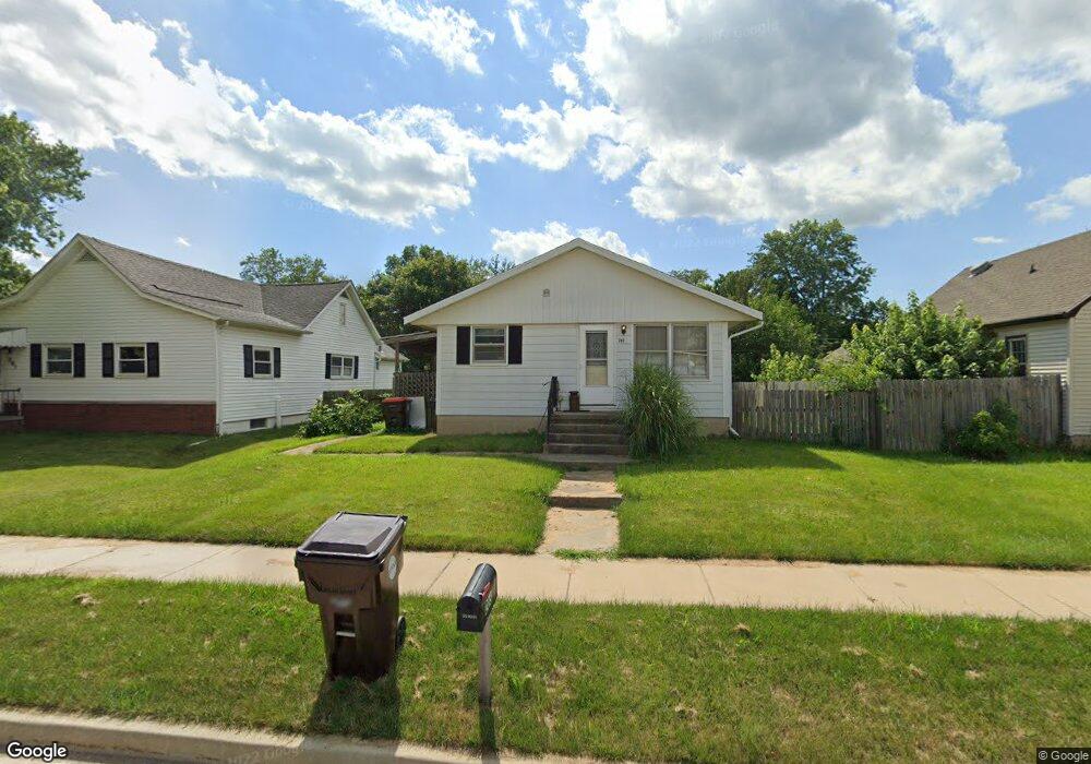
203 N 4th St Dunlap, IL 61525
Estimated Value: $89,000 - $159,000
2
Beds
1
Bath
912
Sq Ft
$129/Sq Ft
Est. Value
About This Home
This home is located at 203 N 4th St, Dunlap, IL 61525 and is currently estimated at $117,630, approximately $128 per square foot. 203 N 4th St is a home located in Peoria County with nearby schools including Dunlap Grade School, Dunlap Valley Middle School, and Dunlap High School.
Ownership History
Date
Name
Owned For
Owner Type
Purchase Details
Closed on
Feb 27, 2025
Sold by
Smkp Properties Llc-Series North
Bought by
Smkp Llc-Series North
Current Estimated Value
Home Financials for this Owner
Home Financials are based on the most recent Mortgage that was taken out on this home.
Original Mortgage
$97,000
Outstanding Balance
$96,670
Interest Rate
6.85%
Mortgage Type
Credit Line Revolving
Estimated Equity
$20,960
Purchase Details
Closed on
Nov 1, 2023
Sold by
Smkp Properties Llc
Bought by
Smkp Properties Llc-Series North
Purchase Details
Closed on
Nov 22, 2022
Sold by
Decker Robert L
Bought by
Smkp Properties Llc
Create a Home Valuation Report for This Property
The Home Valuation Report is an in-depth analysis detailing your home's value as well as a comparison with similar homes in the area
Home Values in the Area
Average Home Value in this Area
Purchase History
| Date | Buyer | Sale Price | Title Company |
|---|---|---|---|
| Smkp Llc-Series North | -- | None Listed On Document | |
| Smkp Properties Llc-Series North | -- | None Listed On Document | |
| Smkp Properties Llc | $81,000 | -- |
Source: Public Records
Mortgage History
| Date | Status | Borrower | Loan Amount |
|---|---|---|---|
| Open | North Smkp Llc-Series | $97,000 |
Source: Public Records
Tax History Compared to Growth
Tax History
| Year | Tax Paid | Tax Assessment Tax Assessment Total Assessment is a certain percentage of the fair market value that is determined by local assessors to be the total taxable value of land and additions on the property. | Land | Improvement |
|---|---|---|---|---|
| 2024 | $2,026 | $28,210 | $5,520 | $22,690 |
| 2023 | $1,921 | $26,620 | $5,210 | $21,410 |
| 2022 | $1,359 | $24,670 | $4,800 | $19,870 |
| 2021 | $1,288 | $23,490 | $4,570 | $18,920 |
| 2020 | $1,250 | $22,810 | $4,440 | $18,370 |
| 2019 | $1,259 | $23,270 | $4,530 | $18,740 |
| 2018 | $1,273 | $23,690 | $4,610 | $19,080 |
| 2017 | $1,357 | $24,680 | $4,800 | $19,880 |
| 2016 | $1,297 | $24,680 | $4,800 | $19,880 |
| 2015 | $1,298 | $23,740 | $4,620 | $19,120 |
| 2014 | $1,263 | $24,090 | $4,680 | $19,410 |
| 2013 | -- | $23,620 | $4,600 | $19,020 |
Source: Public Records
Map
Nearby Homes
- 311 N 2nd St
- 408 N 3rd St
- 504 N 4th St
- 312 S 4th St
- Lot 136 French Dr
- 427 W Westfield Ct
- LOT 209 Copperpoint Dr
- LOT 208 Copperpoint Dr
- LOT 212 Copperpoint Dr
- LOT 204 W Salem School Ct
- 5821 W Dickison Cemetery Rd
- 11801 N Deerfield Dr
- 11518 N Nettle Creek Dr
- 11417 N Route 91 Rd
- 11428 N Boulder Creek Ct
- 7320 W Akron Rd
- 11227 N Stone Creek Dr
- 2203 W Augusta Dr
- 2218 W Augusta Dr
- 2247 W Augusta Dr
- 201 N 4th St
- 205 N 4th St
- 209 N 4th St
- LOT132 Highcrest Ln
- Lot 2 Cedar Hills Rd
- 111 W Birch St
- 113 N 4th St
- 11905 Illinois 91
- 11901 Illinois 91
- 0 N Route 91 Unit 1120113
- 0 N Route 91 Unit RMAPA1058498
- 206 N 5th St
- 213 N 4th St
- 106 W Pine St
- 109 N 4th St
- 110 W Birch St
- 112 N 4th St
- 212 N 5th St
- 107 N 4th St
- 201 W Birch St