Estimated Value: $135,000 - $160,000
3
Beds
1
Bath
1,344
Sq Ft
$109/Sq Ft
Est. Value
About This Home
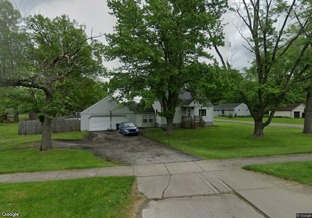
This home is located at 203 North Rd, Niles, OH 44446 and is currently estimated at $146,535, approximately $109 per square foot. 203 North Rd is a home located in Trumbull County with nearby schools including Niles Primary School, Niles Intermediate School, and Niles Middle School.
Ownership History
Date
Name
Owned For
Owner Type
Purchase Details
Closed on
Sep 18, 2002
Sold by
Rindfuss Patricia and Morgan William J
Bought by
Crockett Thomas E
Current Estimated Value
Purchase Details
Closed on
May 10, 2002
Sold by
Morgan William C
Bought by
Rindfuss Patricia and Morgan William J
Purchase Details
Closed on
Apr 1, 2002
Sold by
Morgan William C
Bought by
Morgan William C and Rindfuss Patricia
Purchase Details
Closed on
Jan 1, 1990
Bought by
William C Morgan
Create a Home Valuation Report for This Property
The Home Valuation Report is an in-depth analysis detailing your home's value as well as a comparison with similar homes in the area
Home Values in the Area
Average Home Value in this Area
Purchase History
| Date | Buyer | Sale Price | Title Company |
|---|---|---|---|
| Crockett Thomas E | $71,050 | -- | |
| Rindfuss Patricia | -- | -- | |
| Morgan William C | -- | -- | |
| William C Morgan | -- | -- |
Source: Public Records
Tax History
| Year | Tax Paid | Tax Assessment Tax Assessment Total Assessment is a certain percentage of the fair market value that is determined by local assessors to be the total taxable value of land and additions on the property. | Land | Improvement |
|---|---|---|---|---|
| 2024 | $1,377 | $32,700 | $6,480 | $26,220 |
| 2023 | $1,364 | $32,700 | $6,480 | $26,220 |
| 2022 | $1,313 | $26,890 | $6,480 | $20,410 |
| 2021 | $1,379 | $26,890 | $6,480 | $20,410 |
| 2020 | $1,392 | $26,890 | $6,480 | $20,410 |
| 2019 | $1,462 | $26,890 | $6,480 | $20,410 |
| 2018 | $1,458 | $26,890 | $6,480 | $20,410 |
| 2017 | $1,450 | $26,890 | $6,480 | $20,410 |
| 2016 | $1,420 | $26,080 | $6,480 | $19,600 |
| 2015 | $1,404 | $26,080 | $6,480 | $19,600 |
| 2014 | $1,408 | $26,080 | $6,480 | $19,600 |
| 2013 | $1,399 | $27,340 | $6,480 | $20,860 |
Source: Public Records
Map
Nearby Homes
- 145 North Rd
- 245 North Rd
- 270 North Rd
- 27 Wilson Ave
- 0 Harrison St
- 1309 Ashland Ave
- 1225 Beech St
- 512 John St
- 0 Federal
- 1187 Deforest Rd SE
- 401 Sheridan Ave
- 14 Evans St
- 63 Linden Ave
- 1503 Gypsy Ln
- 46 & 48 Hyde Ave
- 3109 Woodbine Ave SE
- 22 N Arlington Ave
- 124 N Cedar Ave
- 4 N Butler Ave
- 520 Washington Ave
- 21 Saint John Ave
- 221 North Rd
- 175 North Rd
- 153 North Rd
- 23 Saint John Ave
- 306 North Rd
- 16 Saint John Ave
- 231 North Rd
- 22 Saint John Ave
- 158 North Rd
- 237 North Rd
- 230 North Rd
- 35 Saint John Ave
- 30 Saint John Ave
- 34 Saint John Ave
- 39 Saint John Ave
- 38 Saint John Ave
- 251 North Rd
- 108 Blossom Ln
- 104 Blossom Ln
Your Personal Tour Guide
Ask me questions while you tour the home.