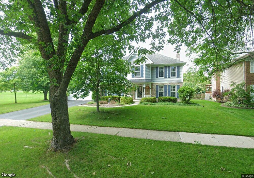
203 Redstart Rd Naperville, IL 60565
Maple Brook NeighborhoodEstimated Value: $697,921 - $949,000
Studio
1
Bath
3,161
Sq Ft
$260/Sq Ft
Est. Value
About This Home
This home is located at 203 Redstart Rd, Naperville, IL 60565 and is currently estimated at $821,730, approximately $259 per square foot. 203 Redstart Rd is a home located in DuPage County with nearby schools including Maplebrook Elementary School, Lincoln Jr. High School, and Naperville Central High School.
Ownership History
Date
Name
Owned For
Owner Type
Purchase Details
Closed on
May 16, 1997
Sold by
Blair Blake L and Blair Emily G
Bought by
Bayert Michael W and Bayert Nicole S
Current Estimated Value
Home Financials for this Owner
Home Financials are based on the most recent Mortgage that was taken out on this home.
Original Mortgage
$206,250
Interest Rate
7.71%
Create a Home Valuation Report for This Property
The Home Valuation Report is an in-depth analysis detailing your home's value as well as a comparison with similar homes in the area
Home Values in the Area
Average Home Value in this Area
Purchase History
| Date | Buyer | Sale Price | Title Company |
|---|---|---|---|
| Bayert Michael W | $286,500 | First American Title |
Source: Public Records
Mortgage History
| Date | Status | Borrower | Loan Amount |
|---|---|---|---|
| Previous Owner | Bayert Michael W | $206,250 |
Source: Public Records
Tax History
| Year | Tax Paid | Tax Assessment Tax Assessment Total Assessment is a certain percentage of the fair market value that is determined by local assessors to be the total taxable value of land and additions on the property. | Land | Improvement |
|---|---|---|---|---|
| 2024 | $12,618 | $213,969 | $82,386 | $131,583 |
| 2023 | $12,169 | $195,280 | $75,190 | $120,090 |
| 2022 | $11,435 | $182,680 | $68,700 | $113,980 |
| 2021 | $11,020 | $175,770 | $66,100 | $109,670 |
| 2020 | $10,786 | $172,610 | $64,910 | $107,700 |
| 2019 | $10,475 | $165,140 | $62,100 | $103,040 |
| 2018 | $10,478 | $165,140 | $62,100 | $103,040 |
| 2017 | $10,270 | $159,570 | $60,010 | $99,560 |
| 2016 | $10,067 | $153,800 | $57,840 | $95,960 |
| 2015 | $10,008 | $144,840 | $54,470 | $90,370 |
| 2014 | $10,123 | $142,000 | $53,400 | $88,600 |
| 2013 | $9,970 | $142,340 | $53,530 | $88,810 |
Source: Public Records
Map
Nearby Homes
- 381 Prairie Knoll Dr
- 48 Starling Ln
- 77 Bluebird Ln
- 44 Swift Ln
- 289 Winding Creek Dr
- 1751 S Washington St Unit 1
- 1678 Cove Ct Unit 5
- 1918 Templar Dr
- 1532 Swallow St
- 2023 Springside Dr
- 2057 Lancaster Cir Unit 102D
- 144 E Bailey Rd Unit G
- 54 Plymouth Ct Unit 102D
- 50 Plymouth Ct Unit 202B
- 2153 Lancaster Cir Unit 102B
- 1317 Carol Ln
- 2132 Berkley Ct Unit 202B
- 1583 Orchard Cir
- 1919 Coach Dr
- 2245 Petworth Ct Unit 202C
- 201 Redstart Rd
- 1649 Verdin Ln
- 300 Prairie Knoll Dr
- 1657 Clyde Dr
- 103 Redstart Rd
- 1645 Verdin Ln
- 300 Redstart Rd
- 1653 Clyde Dr
- 104 Redstart Rd
- 304 Prairie Knoll Dr
- 1641 Verdin Ln
- 305 Prairie Knoll Dr
- 1709 Clyde Dr
- 308 Prairie Knoll Dr
- 304 Redstart Rd
- 1713 Clyde Dr
- 1644 Verdin Ln
- 309 Prairie Knoll Dr
- 1637 Verdin Ln
- 308 Redstart Rd
Your Personal Tour Guide
Ask me questions while you tour the home.